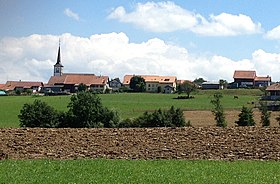
La Folliaz
| La Folliaz | ||
|---|---|---|
| State : |
|
|
| Canton : |
|
|
| District : | Glane | |
| Municipality : | Villaz | |
| Postal code : | 1690 Lussy 1691 Villarimboud |
|
| former BFS no. : | 2116 | |
| Coordinates : | 563653 / 176 583 | |
| Height : | 756 m above sea level M. | |
| Area : | 9.91 km² | |
| Population density : | 99 inhabitants per km² | |
| Website: | www.lafolliaz.ch | |
|
Villarimboud |
||
| map | ||
|
|
||
Until December 31, 2019, La Folliaz was a municipality in the Glane district of the canton of Friborg in Switzerland . On January 1, 2020, it merged with Villaz-Saint-Pierre to form the new municipality of Villaz .
The former municipality was created on January 1st, 2005 through the merger of the previously independent municipalities of Villarimboud and Lussy (FR) . Because the municipality of Villaz-Saint-Pierre, which lies between the two villages, did not participate in the merger, the rare constellation arose that La Folliaz consists of two unconnected parts of the municipality.
geography
La Folliaz is located around 5 km northeast of the district capital Romont (as the crow flies). The municipality extends on the Molasse plateau of the Freiburg Central Plateau , west of the Glâne valley .
The area of the 9.9 km² former municipal area comprises a section of the Molasse Heights of the Freiburg Central Plateau. The municipality part of Villarimboud extends from the Glâne to the northwest over the heights of Villarimboud and Le Châtelet to the catchment area of the Arbogne . The municipality of Lussy extends from the wide valley of the Glâne northeast of Romont over the slope adjacent to the north into the extensive Au Bois forests in the headwaters of the Arbogne. At the height of the forest Sur la Montagne is 812 m above sea level. M. reached the highest point of La Folliaz. In 1997, 6% of the municipal area was in settlements, 19% in forests and woodlands, 74% in agriculture and a little less than 1% was unproductive land.
La Folliaz consists of the villages Villarimboud ( 756 m above sea level ) and Lussy ( 723 m above sea level ), the hamlet of Macconnens ( 710 m above sea level ) and some farm settlements and individual farms. Neighboring municipalities of La Folliaz were Châtonnaye , Torny , La Brillaz , Chénens , Villorsonnens , Villaz-Saint-Pierre and Romont in the canton of Friborg and Villarzel in the canton of Vaud .
population
With 982 inhabitants (as of December 31, 2018), La Folliaz is one of the smaller communities in the canton of Friborg. 96.6% of the residents are French-speaking, 2.2% German-speaking and 0.5% speak English (as of 2000). La Folliaz had a population of 771 in 1900. At the beginning of the 20th century the population increased slowly until 1930 (817 inhabitants), before there was a decrease of almost 30% to 584 people by 1970 due to strong emigration. Since then, the population has grown again significantly.
economy
Until the second half of the 20th century, La Folliaz was a predominantly agricultural village. Today who have dairy industry , the livestock and agriculture an important role in the employment structure of the population. Further jobs are available in local small businesses and in the service sector. In the last few decades the village has also developed into a residential community. Many workers are therefore commuters who work mainly in the Romont and Freiburg regions.
traffic
La Folliaz is off the main thoroughfares, but can be easily reached from the main road from Freiburg to Romont . The railway line from Lausanne via Romont to Freiburg crosses the municipality of La Folliaz, but has no stop on it. The station is in Villaz-Saint-Pierre , around 1.5 km from the center of Lussy, which itself has no connection to the public transport network. From Villaz-Saint-Pierre there is a postbus course to Villarimboud .
history
Since the Middle Ages , the areas of La Folliaz have been under the suzerainty of the House of Savoy . When the Bernese conquered Vaud in 1536, the villages came under the rule of Friborg and were assigned to the Bailiwick of Romont. After the collapse of the Ancien Régime (1798), Lussy and Villarimboud belonged to the Romont district during the Helvetic and the following period and were incorporated into the Glâne district in 1848.
As part of the municipal mergers of the canton of Friborg, a merger of the three villages Lussy, Villarimboud and Villaz-Saint-Pierre was originally planned. However, since the residents of Villaz-Saint-Pierre resisted a merger, on January 1, 2005 only the previously independent municipalities of Lussy (FR) and Villarimboud were merged to form the new municipality of La Folliaz. These localities did not have a common border before, which is why La Folliaz today consists of two parts of the municipality.
Web links
- Official website of the municipality of La Folliaz
- Marianne Rolle: Macconnens. In: Historical Lexicon of Switzerland .
- Evelyne Maradan: Lussy (FR). In: Historical Lexicon of Switzerland .


