
Ecublens FR
| FR is the abbreviation for the canton of Friborg in Switzerland and is used to avoid confusion with other entries of the name Ecublens . |
| Ecublens | |
|---|---|
-coat_of_arms.svg) |
|
| State : |
|
| Canton : |
|
| District : | Glane |
| BFS no. : | 2072 |
| Postal code : | 1673 |
| UN / LOCODE : | CH ELS |
| Coordinates : | 551 754 / 162061 |
| Height : | 594 m above sea level M. |
| Height range : | 531–759 m above sea level M. |
| Area : | 4.88 km² |
| Residents: | 339 (December 31, 2018) |
| Population density : | 69 inhabitants per km² |
| Website: | www.ecublens-fr.ch |
| Location of the municipality | |
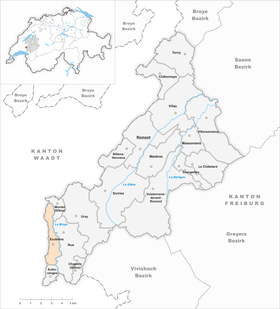  |
|
Ecublens ( Freiburger Patois ) is a municipality in the Glane district in the canton of Friborg in Switzerland . The former German name Scubilingen is no longer used today.
geography
Ecublens lies at 594 m above sea level. M. , 13 km southwest of the district capital Romont and 7 km south of Moudon (air line). The farming village extends on the western slope of the Broye valley , at the foot of the Le Signal forest , in the southwest of the Freiburg Central Plateau .
The area of the 4.9 km² municipal area includes a section on the upper reaches of the Broye. The long area in north-south direction is bounded in the east by the Broye. In the southern part this forms a wide valley low with meadows, while in the northern part it is deepened like a gorge into the molasse layers of the Central Plateau and is partly accompanied by sandstone rocks . To the west, the municipality extends to the slope of the adjacent height and reaches there with 750 m above sea level. M. the highest point of Ecublens. To the north, the area extends over the plateau of Villangeaux to the Bois de Sépey forest ; in the south, the lower part of the Parimbot valley also belongs to Ecublens. In 1997, 7% of the municipal area was in settlements, 24% in forests and woodlands, 67% in agriculture and a little more than 2% was unproductive land.
The villages of Eschiens ( 603 m above sea level ) south of the Parimbot and Villangeaux ( 673 m above sea level ) on a plateau above the Broyetal as well as some farm settlements and individual farms belong to Ecublens . Neighboring municipalities of Ecublens are Montet (Glâne) , Rue and Auboranges in the canton of Friborg and Jorat-Mézières and Vulliens in the canton of Vaud .
population
With 339 inhabitants (as of December 31, 2018), Ecublens is one of the small communities in the canton of Friborg. 91.4% of the residents speak French, 3.4% speak English and 2.6% speak German (as of 2000). The population of Ecublens was 277 in 1900. In the course of the 20th century, the population increased slowly until 1940 (325 inhabitants), before there was a decline of almost 38% to 203 people by 1980 due to strong emigration. Since then a slight population growth has been recorded again.
economy
Until the second half of the 20th century, Ecublens was predominantly an agricultural village. Today who have dairy industry , the livestock and agriculture an important role in the employment structure of the population. Further jobs are available in local small businesses and in the service sector. In the last few decades the village has also developed into a residential community. Many workers are therefore commuters who work mainly in the Moudon and Oron-la-Ville regions.
traffic
The community is located off the main thoroughfares on a connecting road from Rue to Mézières . On August 25, 1876, the railway line from Moudon to Palézieux-Gare with a station in Ecublens was put into operation. The nearest bus stop (Rue, L'Abergement) is just 1 km from the center of the city, on the route of the Freiburg public transport company , which runs from Romont via Ursy and Oron-la-Ville to Palézieux-Gare.
history
The municipality of Ecublens was settled very early, which is attested by the finds of a grave from the La Tène period and the wall foundations of a Roman building near Villangeaux. The first written mention of the place took place in 1180 under the name Escublens . The spellings Escublans (1220) and Escubleins (1226) also appeared later . The place name goes back to the Burgundian personal name Scubila and means with the suffix -ens as much as the people of the Scubila .
Since the Middle Ages, Ecublens has belonged to the Rue lordship, which was under the sovereignty of the House of Savoy . When the Bernese conquered Vaud in 1536, the village came under the rule of Friborg and was assigned to the Bailiwick of Rue. After the collapse of the Ancien Régime (1798), Ecublens belonged to the Rue district during the Helvetic and the following period, and was incorporated into the Glâne district in 1848.
The three villages of Ecublens, Eschiens and Villangeaux had been administered jointly since 1883, but remained politically independent municipalities. On March 1, 1969, Villangeaux and Eschiens were incorporated into Ecublens. As part of the municipal mergers promoted by the canton of Friborg since 2000, Ecublens was to merge with Promasens and Gillarens with Rue . However, due to insufficient support from the village population, the idea is not being pursued any further at the moment.
Attractions
The Chapel of the Exaltation of the Cross, built in 1939, is in Ecublens. The village belongs to the parish of Promasens .
Web links
- Jean-Pierre Dewarrat: Ecublens (FR). In: Historical Lexicon of Switzerland .
- Jean-Pierre Dewarrat: Eschiens. In: Historical Lexicon of Switzerland .
- Aerial photos of Ecublens
Individual evidence
- ↑ Permanent and non-permanent resident population by year, canton, district, municipality, population type and gender (permanent resident population). In: bfs. admin.ch . Federal Statistical Office (FSO), August 31, 2019, accessed on December 22, 2019 .
Auboranges | Billens-Hennens | Chapelle (Glâne) | Châtonnaye | Ecublens | Grangettes | Le Châtelard | Massonnens | Mezieres | Montet (Glâne) | Romont | Rue | Siviriez | Torny | Ursy | Villaz | Villorsonnens | Vuisternens-devant-Romont
Former parishes: Arrufens | Berlens | Bionnens | Billens | Blessens | Chavannes-les-Forts | Chavannes-sous-Orsonnens | Eschiens | Esmonts | Estévenens | Fuyens | Gillarens | Grange-la-Battiaz | Hennens | La Folliaz | La Joux | La Magne | La Neirigue | Le Saulgy | Les Ecasseys | Les Glânes | Lussy | Lieffrens | Macconnens | Middes | Morlens | Mossel | Orsonnens | Prez-vers-Siviriez | Promasens | Sommentier | Torny-le-Grand | Vauderens | Villangeaux | Villaraboud | Villaranon | Villargiroud | Villariaz | Villarimboud | Villarsiviriaux | Villaz-Saint-Pierre | Vuarmarens
Canton of Friborg | Districts of the canton of Friborg | Municipalities of the canton of Friborg