
Parimbot
|
Parimbot Parimboz, Parimboux, Parimbois |
||
|
|
||
| Data | ||
| Water code | CH : 249 | |
| location | Switzerland | |
| River system | Rhine | |
| Drain over | Broye → Zihl Canal → Aare → Rhine → North Sea | |
| source | at Essertes 46 ° 33 ′ 39 ″ N , 6 ° 47 ′ 3 ″ E |
|
| Source height | approx. 740 m above sea level M. | |
| muzzle | near Ecublens in the Broye coordinates: 46 ° 36 '32 " N , 6 ° 48' 59" E ; CH1903: 552 326 / 162.14 thousand 46 ° 36 '32 " N , 6 ° 48' 59" O |
|
| Mouth height | 570 m above sea level M. | |
| Height difference | approx. 170 m | |
| Bottom slope | approx. 25 ‰ | |
| length | 6.7 km | |
| Catchment area | 7.79 km² | |
| Discharge at the Ecublens A Eo gauge : 6.75 km² |
NNQ (1989) MNQ 1979–2012 MQ 1979–2012 Mq 1979–2012 MHQ 1979–2012 HHQ (1995) |
0 l / s 76 l / s 163 l / s 24.1 l / (s km²) 251 l / s 13.4 m³ / s |
The Parimbot , also known as Parimboz , Parimboux and Parimbois , is a seven-kilometer-long left tributary of the Broye in the Swiss cantons of Vaud and Friborg . It drains a section of the Jorat and belongs to the catchment area of the Rhine . The stream was mentioned as Peremboc as early as the 12th century .
geography
course
The headwaters of the Parimbot are located at about 740 m above sea level. M. in the municipality of Essertes in the canton of Vaud. The Parimbot flows north and after about 1 km of brook it forms the border with the municipality of Servion in the Essertes area alone . After another kilometer, the Parimbot forms the border between the cantons of Vaud and Friborg, and between the municipalities of Servion and Auboranges . The brook flows further north, crosses the east side of the Bois de Ban and crosses over to Freiburg territory at the municipal boundary of Auboranges and Ferlens . Here it flows through the municipality of Ecublens and leaves the Bois de Ban again above this town . It touches the hamlet of Eschiens before it reaches 570 m above sea level after seven kilometers of creek . M. joins the Broye from the left. On the course of its stream it is mostly accompanied by a narrow forest border.
Catchment area
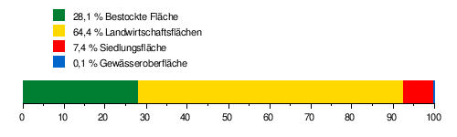
The catchment area of the Parimbot is 7.79 km² and consists of 28.1% forest land , 64.4% agricultural area , 7.4% settlement area and 0.1% water area.
The mean height of the catchment area is 707 m above sea level. M. , the minimum height is 570 m above sea level. M. and the maximum height at 821 m above sea level. M.
Tributaries
- Le Ruisseau de Cottens ( left )
Individual evidence
- ↑ a b c d Geoserver of the Swiss Federal Administration ( information )
- ↑ Discharge at the Ecublens gauge (1979 to 2012) (PDF) Federal Office for the Environment
- ↑ Topographical catchment areas of Swiss waters: Parimbot