
Orsonnens
| Orsonnens | ||
|---|---|---|
 |
||
| State : |
|
|
| Canton : |
|
|
| District : | Glane | |
| Municipality : | Villorsonnens | |
| Postal code : | 1694 | |
| former BFS no. : | XXXX | |
| Coordinates : | 566463 / 174 034 | |
| Height : | 699 m above sea level M. | |
| Residents: | 307 (2002) | |
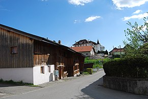
_194.JPG) Orsonnens village center |
||
| map | ||
|
||


Orsonnens ( Freiburger Patois ) is a town and formerly an independent political municipality in the Glane district of the canton of Friborg in Switzerland . The former German names Orsonning and Orsonningen are no longer used today. On January 1, 2001, Orsonnens merged with the previously independent municipalities of Chavannes-sous-Orsonnens , Villargiroud and Villarsiviriaux to form the new municipality of Villorsonnens .
geography
Orsonnens is 699 m above sea level. M. , six kilometers east-northeast of the district capital Romont (linear distance ). The village extends on a ledge on the southern edge of the Neirigue valley , shortly before its confluence with the Glâne , in the Molasse hills of the Freiburg Central Plateau northwest of the Gibloux . The former municipality area was around 4.0 km². The area was bounded in the north by the Neirigue, extended to the east over the height of Fin d'Avau ( 706 m above sea level ) into the forest Bois de Vernex ( 725 m above sea level ). To the south, the area extended over the slope of Orsonnens to the northern slope of the Bois de Saugy forest .
population
With 309 inhabitants (1997), Orsonnens was one of the small communities in the canton of Friborg before the merger. Orsonnens includes the hamlet of Le Moulin ( 660 m above sea level ) on the Neirigue as well as several farm settlements and individual farms.
economy
Orsonnens was a predominantly agricultural village until the second half of the 20th century . Mills used to be operated at Neirigue. Today who have dairy industry , the livestock and agriculture an important role in the employment structure of the population. Further jobs are available in local small businesses and in the service sector. There is a gravel pit northeast of the village. In the last few decades the village has also developed into a residential community. Many workers are therefore commuters who work mainly in the Romont and Freiburg regions.
traffic
The village is located off the main thoroughfares on a connecting road from Villaz-Saint-Pierre to Vuisternens-en-Ogoz . Orsonnens is connected to the public transport network by the Transports publics Fribourgeois bus service , which runs from Romont to Farvagny .
history
The first written mention of the place took place in 1143 under the name Orsenens . The spellings Orsenein (1180), Orsonneyns (1326), Orsonens (1577) and Orsonnens (1693) appeared later . The place name is derived from the Germanized personal name Ursin and means with the suffix -ens as much as for the people of Ursin.
Since the Middle Ages , Orsonnens formed its own small rule, which was subordinate to the barons of Pont-en-Ogoz . During the war of the Freiburgers against the Savoyers in 1448, the village was badly affected. From the end of the 15th century Orsonnens came under the rule of Freiburg. The new masters assigned the village to the Bailiwick of Pont-Farvagny. After the collapse of the Ancien Régime (1798), Orsonnens belonged to the Romont district until 1803, then to the Farvagny district and was incorporated into the Glâne district with the new cantonal constitution in 1848.
As part of the municipal mergers promoted by the canton of Friborg since 2000, the villages of Orsonnens, Chavannes-sous-Orsonnens , Villargiroud and Villarsiviriaux were merged with effect from January 1, 2001. The newly created political municipality was given the name Villorsonnens.
Attractions
Orsonnens already owned a parish church in the 12th century. Because the old church (with a Gothic nave) was too small, it had to give way in 1936 to a modern new building designed by the architect Fernand Dumas . The Upper Castle (Château d'En Haut) dates from 1629, while the Lower Castle (Château du Bas; also known as the country house Elie Page) dates back to the 16th century. Some characteristic farmhouses from the 17th to 19th centuries have been preserved in the town center.
The Cistercian monastery in the Upper Castle
The Upper Castle housed an Ursuline home economics school from 1891 to 1977 . Since 1979, under the monastery name Notre-Dame de Fatima, it has been a priory of the Vietnamese Cistercians who came to study theology at Hauterive Monastery since 1953 and sought refuge in Switzerland , especially since the fall of Saigon in 1975. The currently around 20 monks make their living with a printing shop (plus bookbinding) and the production of tofu . The prior is Joannes Baptista Trần Văn Chuyên.
Lower castle, Orsonnens

Hotel Cheval Blanc
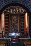
Interior of the Saint Peter church

Stained glass in the Saint Peter church

Upper Castle, Orsonnens
_229.JPG)
_230.JPG)


_188.JPG)
Literature (about the monastery)
- Patrick Gilliéron Lopreno: Monastères. Hauterive, Montorge, Notre-Dame de Fatima, Saint-Maurice . Labor et Fides, Geneva 2014.
- Bernard Peugniez : Guide-Routier de l'Europe cistercienne. Strasbourg 2012, p. 625.
Web links
- Aerial views of the village
- Marianne Rolle: Orsonnens. In: Historical Lexicon of Switzerland .
- "Orsonnens" page in the Cistopedia
- "Orsonnens" entry on the Certosa di Firenze website, with localization
- Blog from 2012 about tofu production in the monastery
- Monastery market side, French, with picture
- Map of western Switzerland with Cistercian monasteries
- Photo of the monastery building (castle)
Auboranges | Billens-Hennens | Chapelle (Glâne) | Châtonnaye | Ecublens | Grangettes | Le Châtelard | Massonnens | Mezieres | Montet (Glâne) | Romont | Rue | Siviriez | Torny | Ursy | Villaz | Villorsonnens | Vuisternens-devant-Romont
Former parishes: Arrufens | Berlens | Bionnens | Billens | Blessens | Chavannes-les-Forts | Chavannes-sous-Orsonnens | Eschiens | Esmonts | Estévenens | Fuyens | Gillarens | Grange-la-Battiaz | Hennens | La Folliaz | La Joux | La Magne | La Neirigue | Le Saulgy | Les Ecasseys | Les Glânes | Lussy | Lieffrens | Macconnens | Middes | Morlens | Mossel | Orsonnens | Prez-vers-Siviriez | Promasens | Sommentier | Torny-le-Grand | Vauderens | Villangeaux | Villaraboud | Villaranon | Villargiroud | Villariaz | Villarimboud | Villarsiviriaux | Villaz-Saint-Pierre | Vuarmarens
Canton of Friborg | Districts of the canton of Friborg | Municipalities of the canton of Friborg