
Farvagny
| Farvagny | ||
|---|---|---|
 |
||
| State : |
|
|
| Canton : |
|
|
| District : | Saane | |
| Municipality : | Gibloux | |
| Postal code : | 1726 | |
| former BFS no. : | 2192 | |
| Coordinates : | 571 392 / 174 441 | |
| Height : | 700 m above sea level M. | |
| Area : | 10.03 km² | |
| Residents: | 2215 (December 31, 2014) | |
| Population density : | 221 inhabitants per km² | |
| Website: | commune-gibloux.ch | |
_089.JPG) Farvagny |
||
| map | ||
|
||


Farvagny was a municipality in the District de la Sarine (German: Saanebezirk) in the canton of Friborg in Switzerland until December 31, 2015 . The former German place name Favernach is no longer used today. The municipality was formed on January 1, 1996 from the merger of the former municipalities Farvagny-le-Grand ( Freiburger Patois ), Farvagny-le-Petit (Freiburger Patois ), Grenilles and Posat formed. On January 1, 2016, Farvagny merged with the municipalities of Corpataux-Magnedens , Le Glèbe , Rossens and Vuisternens-en-Ogoz to form the new municipality of Gibloux .
geography
Farvagny is 700 m above sea level. M. , 12 km southwest of the canton capital Friborg (linear distance). The village extends in the valley basin of the Longivue at the northern foot of Mont Gibloux , west of the Saanegraben , in the Molasse hills of the Freiburg Central Plateau , in the Ogoz region.
The area of the 10.0 km² former municipal area comprises a section of the gently undulating Molasse plateau between the valleys of Glâne in the west and Saane in the east. The central part of the municipality is occupied by the 500 to 700 m wide flat valley basin of the Longivue , which flows from west to east, gradually sinks into the molasse layers below Grenilles and finally flows into the Glâne. South of the Longivue, the communal soil extends over the slope of Farvagny-le-Grand to the foot of the Gibloux hill range and reaches Montban in the forest at 800 m above sea level. M. the highest point of Farvagny. The Gros Dévin forest in the headwaters of the Longivue is also part of Farvagny.
North of the Longivue valley basin, the municipal spell extends over the wide ridge of Le Saugy ( 741 m above sea level ) and the valley of Posat into the extensive Bois Cornard forest . The north-western border runs in the densely forested valley of the Glâne, which is cut deep into the Molasse plateau. In 1997, 11% of the municipal area was in settlements, 21% in forests and woodlands, 67% in agriculture and a little less than 1% was unproductive land.
Farvagny consists of the districts:
- Farvagny-le-Grand (formerly German: Grossfavernach), 700 m above sea level. M. , on the southern edge of the Longivue Mulde and at the foot of the Gibloux, 1136 inhabitants (1995), former municipal area of around 3.6 km².
- Farvagny-le-Petit (formerly German: Kleinfavernach), 700 m above sea level. M. , on the northern edge of the Longivue basin and at the foot of the height of Le Saugy, 264 inhabitants (1995), former municipal area of around 2.7 km².
- Grenilles , 682 m above sea level M. , on the slope north of the Longivue, 92 inhabitants (1995), former municipal area of around 1.9 km².
- Posat , 664 m above sea level M. , on the plateau east of the Glânetal, 70 inhabitants (1995), former municipal area of around 2.0 km².
Various individual farms also belong to the former community. Neighboring municipalities to Farvagny were Hauterive , Corpataux-Magnedens , Rossens , Pont-en-Ogoz , Vuisternens-en-Ogoz , Le Glèbe , Autigny and Cottens .
population
With 2215 inhabitants (as of December 31, 2014) Farvagny was one of the medium-sized municipalities in the canton of Friborg. 92.1% of the residents are French-speaking, 4.7% German-speaking and 1.0% speak Portuguese (as of 2000). Farvagny had a population of 841 in 1900. In the course of the 20th century, the population decreased by around 13% to 727 people by 1960. Since then there has been a significant increase in population combined with a doubling of the number of inhabitants within 40 years. The population increase in recent years is concentrated in the districts of Farvagny-le-Grand and Farvagny-le-Petit, which have now almost grown together.
economy
Farvagny was a predominantly agricultural village until the second half of the 20th century . Up until the 19th century, straw weaving was also of great importance. During the Second World War , peat was cut in the valley of the Longivue. Even today, the have farming , the fruit production , the dairy industry and animal husbandry an important role in the employment structure of the population.
Numerous other jobs are available in local small businesses and in the service sector. Since the 1970s, Farvagny has developed into a regional center thanks to its good transport links. Various small and medium-sized companies have since settled in the village. Today the branches of construction and transport, telecommunications, precision engineering workshops, the manufacture of pumps and wood processing are represented. Farvagny-le-Grand has been the location of a shopping center and a retirement and nursing home since 1991. Several gravel pits are being exploited in the Farvagny area.
In the last few decades the village has also developed into a residential community. Many workers are therefore commuters who mainly work in the Freiburg region.
traffic
The former community is well developed in terms of traffic. It is only a little west of the main road from Freiburg to Bulle . The next connection to the A12 motorway (Bern-Vevey), which was opened in 1979 and crosses the municipality in the east, is around 2 km from the town center.
Farvagny-le-Grand and Farvagny-le-Petit are connected to the public transport network by the Transports publics fribourgeois bus route from Freiburg to Bulle . Farvagny-le-Grand is also served by the bus routes that go from Freiburg to Rueyres-Saint-Laurent and from Cottens to Farvagny. From 1916 to 1932, the Gleislose Bahn Freiburg – Farvagny (an early trolleybus company ) served both districts with one station each.
history

The place was first mentioned in a document in 1082 under the name Faverneis . Later the names Fauarniaco , Fauarniei , Fauernie appeared in the 12th century, Fauerni (1177), Favernie (1228), Favarnye (1285), Fauarnier (1342), Fauarnye (1445) and Faruagnie (1668). Fauernachen (1555) and Fauernach (1578) have been handed down as German versions . The place name goes back to the Gallo-Roman personal name Fabrinius .

Since the Middle Ages , Farvagny has belonged to the Pont dominion, which in 1250 came under the influence of the Counts of Savoy. Farvagny was a parish even before it was first mentioned. The Canons of the Great Saint Bernhard founded a priory in the village in 1228.

By purchase, Farvagny came under the rule of Freiburg in 1483, together with the lordship of Pont. This converted the rule into the bailiwick of Pont-Farvagny. When the Pont Castle fell into disrepair at the beginning of the 17th century, Farvagny became the new capital of the Bailiwick in 1617. From now on, the bailiffs resided in the former courthouse of Farvagny-le-Grand, which was converted into a castle. In the 17th century the citizens of Farvagny were granted certain freedoms by the city of Freiburg.
After the French troops marched in in 1798, which heralded the end of the Ancien Régime , the Vogt and the villagers remained loyal to the city of Freiburg until the surrender. During the Helvetic Republic , Farvagny was part of the Romont district. In 1803 it was raised to the capital of the Farvagny district before it was incorporated into the Saane district in 1848 with the new cantonal constitution.
In 1995 the inhabitants of Farvagny-le-Grand, Farvagny-le-Petit, Grenilles and Posat decided to merge their parishes. This resulted in the first large municipal merger in the canton of Friborg, which became legally binding on January 1, 1996; the new parish was named Farvagny. At the same time, a new coat of arms was introduced for the entire community.
Attractions
The parish church of Saint-Vincent was built from 1888 to 1892 on the site of a previous building from the High Middle Ages. It shows neo-Gothic styles, a high bell tower and rich interior fittings from the time it was built. Near the church is the castle, a former courthouse, which was expanded by Freiburg to the residence of the bailiffs in 1617-25. It has a round stair tower and a portal with a coat of arms from 1617. The Saint-Claude chapel in Farvagny-le-Petit was given its current appearance when it was rebuilt in 1709. In the various districts of Farvagny, there are some characteristic farmhouses from the 17th to 19th centuries. Century preserved.
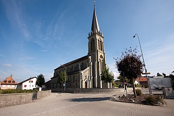
Parish Church of Saint Vincent

Parish church from the front

Interior of the church
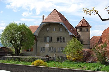
Farvagny Castle

_101.JPG)
_105.JPG)
_115.JPG)
Web links
- Official website of the Municipality of Farvagny (French)
- Marianne Rolle: Farvagny. In: Historical Lexicon of Switzerland .
- Hubert Guisolan: Farvagny-le-Grand. In: Historical Lexicon of Switzerland .
- Marianne Rolle: Farvagny-le-Petit. In: Historical Lexicon of Switzerland .
- Marianne Rolle: Grenilles. In: Historical Lexicon of Switzerland .
Arconciel | Autigny | Avry | Belfaux | Chénens | Corminboeuf | Cottens | Ependes | Ferpicloz | Freiburg | Gibloux | Givisiez | Granges-Paccot | Grolley | Hauterive | La Brillaz | La Sonnaz | Le Mouret | Marly | Matran | Neyruz | Pierrafortscha | Ponthaux | Prez | Senèdes | Treyvaux | Villarsel-sur-Marly | Villars-sur-Glâne
Former parishes: Autafond | Avry-sur-Matran | Bonnefontaine | Chésalles | Chésopelloz | Cormagens | Corpataux | Corpataux-Magnedens | Corsalettes | Corserey | Corjolens | Cutterwil | Ecuvillens | Essert | Estavayer-le-Gibloux | Farvagny | Farvagny-le-Grand | Farvagny-le-Petit | Formangueires | Grenilles | Illens | La Corbaz | Le Glèbe | Lentigny | Lossy | Lossy Formangueires | Lovens | Magnedens | Marly-le-Grand | Marly-le-Petit | Montécu | Montévraz | Nierlet-les-Bois | Noréaz | Oberried | Onnens | Posat | Posieux | Prelude | Prez-vers-Noréaz | Rossens | Rueyres-Saint-Laurent | Sales | Villarlod | Villarsel-le-Gibloux | Vuisternens-en-Ogoz | Zénauva
Canton of Friborg | Districts of the canton of Friborg | Municipalities of the canton of Friborg