Belfaux
| Belfaux | |
|---|---|
| State : |
|
| Canton : |
|
| District : | Saane |
| BFS no. : | 2175 |
| Postal code : | 1782 |
| UN / LOCODE : | CH BFX |
| Coordinates : | 574.71 thousand / 185 636 |
| Height : | 584 m above sea level M. |
| Height range : | 559–736 m above sea level M. |
| Area : | 8.88 km² |
| Residents: | 3283 (December 31, 2018) |
| Population density : | 370 inhabitants per km² |
| Website: | www.belfaux.ch |
|
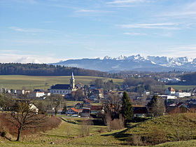
Belfaux with a view of the mountains of the Gantrisch area |
|
| Location of the municipality | |
Belfaux ( Freiburger Patois ) is a municipality in the District de la Sarine (German: Saanebezirk) in the canton of Friborg in Switzerland . The former German name Gumschen is hardly used today.
geography
Belfaux is 584 m above sea level. M. , 4.5 km west-northwest of the canton capital Friborg (linear distance). The village extends on a terrace on the southern slope of the Sonnaz , in the Molasse hills of the Freiburg Central Plateau . It belongs to the Freiburg agglomeration .
The area of the 6.4 km² municipal area comprises a section of the Molasse Heights west of Freiburg. The southern part of the municipality is crossed from southwest to northeast by the wide basin of the Sonnaz. To the south of the Sonnaz, the area extends over the gently rising slope of Belfaux to the adjacent heights of Corminboeuf and Bois de la Faye (up to 640 m above sea level ). In between is the valley of the Ruisseau du Tiguelet . To the northwest, the municipality extends to the forest heights Bois des Dévins ( 672 m above sea level. M. ) and over the extensive Forêt Cantonale , in which 700 m above sea level. M. the highest point of Belfaux is reached, except for the slightly undulating high plateau at the village of Misery to the north. In 1997, 15% of the municipal area was in settlements, 31% in forests and woodlands, 53% in agriculture and a little less than 1% was unproductive land. Belfaux includes extensive housing estates, the village of Cutterwil ( 633 m above sea level ), which used to be an independent municipality, and several individual farms. Belfaux's neighboring municipalities are La Sonnaz , Givisiez , Corminboeuf , Ponthaux , Grolley and Misery-Courtion .
population
With 3283 inhabitants (as of December 31, 2018) Belfaux is one of the medium-sized municipalities in the canton of Friborg. Of the residents, 85.4% are French-speaking, 7.5% German-speaking and 1.5% speak Macedonian (as of 2000). The population of Belfaux was 474 in 1850 and 615 in 1900. In the course of the 20th century, the population continued to grow. Since 1970 (1156 inhabitants) there has been rapid population growth combined with a doubling of the population within 30 years. The settlement area of Belfaux has now almost merged with that of Corminboeuf.
economy
Until the middle of the 20th century, Belfaux was a predominantly agricultural village. Even today, agriculture , dairy farming and cattle breeding have a certain role in the income structure of the population. Numerous other jobs are available in local small businesses and in the service sector. In 1964 an aluminum foundry was founded in Belfaux. Since the 1970s, other small and medium-sized companies have been added, which are active in the advertising industry, the pharmaceutical industry, information technology, fish farming, horticulture and the manufacture of stone slabs. In the last few decades the village has also developed into a residential community. New residential quarters were built above Belfaux and on the northern slopes of the Sonnaz valley. Numerous workers are therefore commuters who mainly work in the Freiburg region.
traffic
The community is very well developed in terms of transport. It is located on the main road from Freiburg via Grolley to Payerne . The closest connection to the A12 motorway (Bern-Vevey) is around 3 km from the town center. On August 25, 1876, the railway line from Freiburg to Payerne with a station in Belfaux was put into operation. The station on the Freiburg - Murten line, which opened on August 23, 1898, came closer to the village center . Two bus routes operated by Transports publics Fribourgeois from Freiburg to Domdidier and Cournillens provide for the fine distribution of public transport .
history
The municipality of Belfaux was settled very early. The earliest traces that indicate the presence of humans go back to the Mesolithic . A well was found near Pré-Saint-Maurice, which was used during the Hallstatt period. Traces of settlement and graves have also been discovered from the La Tène , Roman and Burgundian times.
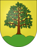
The first written mention of the place took place in the 12th century under the names Bel Fo and Bellofago . Later, the names Belfo (1228), Bellfozen (1229) and Belfol (1416) appeared. The place name is derived from the Latin words bellus fagus (beautiful beech). The German versions Gumeschon and Gumschenn are handed down in 1283 and 1555 respectively.
Belfaux belonged to the lordship of Montagny in the Middle Ages and came under the suzerainty of the House of Habsburg in 1283. The village came under the rule of Freiburg through purchase in 1442 and was assigned to the old landscape (Spitalpanner). The parish church of Saint-Etienne was destroyed by fire in 1470, whereby a large wooden crucifix from the 13th century was miraculously spared. As a result, the rebuilt church became an important pilgrimage destination, especially because all believers who visited the house of God on a Friday or donated alms could count on 40 days of indulgence, according to the Bishop of Saint-Etienne. The streams of pilgrims reached their peak especially during the 17th and 18th centuries.
After the collapse of the Ancien Régime (1798), Belfaux belonged to the Friborg district during the Helvetic and the following period, before it was incorporated into the Saane district in 1848 with the new cantonal constitution. General Dufour had his quarters in Belfaux during the Sonderbund War . Here the Freiburg government signed the document of surrender on November 14, 1847. With effect from January 1, 1977, the previously independent Cutterwil was incorporated into Belfaux.
Attractions
The parish church of Saint-Etienne was first mentioned in 1138 and rebuilt from 1841 to 1852 in the neoclassical style. It is a monumental three-aisled building with a semicircular apse . In the choir there is a wooden crucifix from the 13th century. Just like the parish church, the Lanthen-Heid manor house has been entered in the register as a cultural asset of national importance .
The Auberge du Mouton from 1759 stands next to the church. In the town center there are some characteristic farmhouses and patrician houses from the 17th to 19th centuries. On the left of the road to Misery there is a house with cross-frame windows and a portal, dated 1630.
The Château du Bois was built at the beginning of the 18th century and now houses a private school.
Personalities
- Leonhard Maria Weber (1912–1969), Catholic theologian
- Alain Berset (* 1972), Council of States and Federal Councilor
- Lauriane Sallin (* 1993), Miss Switzerland 2015
Web links
- Official website of the municipality of Belfaux (French)
- Simone Vörös: Belfaux. In: Historical Lexicon of Switzerland .
- Aerial views of the village
Individual evidence
- ↑ Permanent and non-permanent resident population by year, canton, district, municipality, population type and gender (permanent resident population). In: bfs. admin.ch . Federal Statistical Office (FSO), August 31, 2019, accessed on December 22, 2019 .
- ↑ parliament.ch biography


