
Ponthaux
| Ponthaux | |
|---|---|
 |
|
| State : |
|
| Canton : |
|
| District : | Saane |
| BFS no. : | 2217 |
| Postal code : | 1772 |
| Coordinates : | 569 598 / 185011 |
| Height : | 650 m above sea level M. |
| Height range : | 580–739 m above sea level M. |
| Area : | 5.91 km² |
| Residents: | 745 (December 31, 2018) |
| Population density : | 126 inhabitants per km² |
| Website: | www.ponthaux.ch |
_126.JPG) Village center of Ponthaux with church |
|
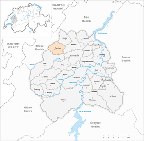
| Location of the municipality | |
  |
|
Ponthaux ( Freiburger Patois ) is a municipality in the District de la Sarine (German: Saanebezirk) in the canton of Friborg in Switzerland .
geography
Ponthaux lies at 650 m above sea level. M. , 9 km west of the canton capital Friborg (beeline). The farming village extends on a high plateau and in the slight hollow of the Ruisseau des Chaudeires brook in the Molasse hill country of the Freiburg Central Plateau .
The area of the 6.0 km² municipality covers a section of the Molasse Heights between the Broye plain in the northwest and the Glânetal in the southeast. Most of the community area is taken up by the gently undulating high plateau of Ponthaux, which is drained on the one hand by the Ruisseau des Chaudeires to the west to the Arbogne , on the other hand by the village stream from Grolley to the north to the Chandon . In the west, the parish soil extends to the edge of the La Bandeire forest ( 660 m above sea level ) in the headwaters of the Chandon. To the east, the area extends over the height of Le Boulex ( 708 m above sea level ) to the Forêt de l'Etat , in which at 738 m above sea level. M. the highest point of Ponthaux is reached. A small portion of the community ban in the southeast is in the catchment area of the Sonnaz . In 1997, 6% of the municipal area was accounted for by settlements, 23% for forests and woodlands and 71% for agriculture.
The village of Nierlet-les-Bois ( 674 m above sea level ) at the western foot of the forest hill of the Forêt de l'Etat as well as various individual farms belong to Ponthaux . Ponthaux's neighboring municipalities are Grolley , Belfaux , Corminboeuf , Prez , Montagny and Belmont-Broye .
population
With 745 inhabitants (as of December 31, 2018), Ponthaux is one of the smaller communities in the canton of Friborg. 89.1% of the residents are French-speaking, 8.8% German-speaking and 0.8% speak Portuguese (as of 2000). The population of Ponthaux was 350 in 1900. In the course of the 20th century the population fluctuated between 320 and 380 inhabitants. Since 1970 (336 inhabitants) there has been a significant increase in population.
economy
Until the second half of the 20th century, Ponthaux was a predominantly agricultural village. Even today, the have farming , the fruit production , the dairy industry and animal husbandry an important role in the employment structure of the population. Further jobs are available in local small businesses and in the service sector, including in a mechanical workshop. In the last few decades the village has also developed into a residential community. Many workers are therefore commuters who mainly work in the Freiburg region.
traffic
The community is located off the main thoroughfares on a connecting road from Prez-vers-Noréaz to Grolley . Ponthaux is connected to the public transport network by a bus line operated by Transports publics Fribourgeois , which runs from Freiburg to Nierlets-les-Bois.
history
The place was first mentioned in 1142 under the name Pontet . The names Pontouz (1170) and Pontouzen (1294) appeared later . The place name is derived from the Latin word pons (bridge). Ponthaux has been part of the Montagny domain since the Middle Ages . In 1447 the village was cremated by the former in the war between the Freiburgers and the Savoy.
Through purchase, Ponthaux came under the rule of Freiburg in 1478 and was assigned to the Bailiwick of Montagny. After the collapse of the Ancien Régime (1798), the village belonged to the Payerne district during the Helvetic period , to the Montagny district from 1803 and to the Friborg district from 1815, before it was incorporated into the Saane district in 1848 with the new cantonal constitution. On January 1, 1981, the previously independent municipality of Nierlet-les-Bois was incorporated into Ponthaux.
Attractions
The parish church of Saint-Maurice was built in 1882. There is a chapel in Nierlet-les-Bois.

Saint-Maurice Church

Interior of the church
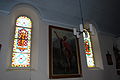
Church windows and paintings inside the church

school
_127.JPG)
_133.JPG)
_136.JPG)
_118.JPG)
Web links
- Official website of the municipality of Ponthaux (French)
- Aerial views of the village
- Marianne Rolle / GL: Ponthaux. In: Historical Lexicon of Switzerland .
Individual evidence
- ↑ Permanent and non-permanent resident population by year, canton, district, municipality, population type and gender (permanent resident population). In: bfs. admin.ch . Federal Statistical Office (FSO), August 31, 2019, accessed on December 22, 2019 .
Arconciel | Autigny | Avry | Belfaux | Chénens | Corminboeuf | Cottens | Ependes | Ferpicloz | Freiburg | Gibloux | Givisiez | Granges-Paccot | Grolley | Hauterive | La Brillaz | La Sonnaz | Le Mouret | Marly | Matran | Neyruz | Pierrafortscha | Ponthaux | Prez | Senèdes | Treyvaux | Villarsel-sur-Marly | Villars-sur-Glâne
Former parishes: Autafond | Avry-sur-Matran | Bonnefontaine | Chésalles | Chésopelloz | Cormagens | Corpataux | Corpataux-Magnedens | Corsalettes | Corserey | Corjolens | Cutterwil | Ecuvillens | Essert | Estavayer-le-Gibloux | Farvagny | Farvagny-le-Grand | Farvagny-le-Petit | Formangueires | Grenilles | Illens | La Corbaz | Le Glèbe | Lentigny | Lossy | Lossy Formangueires | Lovens | Magnedens | Marly-le-Grand | Marly-le-Petit | Montécu | Montévraz | Nierlet-les-Bois | Noréaz | Oberried | Onnens | Posat | Posieux | Prelude | Prez-vers-Noréaz | Rossens | Rueyres-Saint-Laurent | Sales | Villarlod | Villarsel-le-Gibloux | Vuisternens-en-Ogoz | Zénauva
Canton of Friborg | Districts of the canton of Friborg | Municipalities of the canton of Friborg