Noréaz FR
| FR is the abbreviation for the canton of Friborg in Switzerland and is used to avoid confusion with other entries of the name Noréaz . |
| Noréaz | ||
|---|---|---|
| State : |
|
|
| Canton : |
|
|
| District : | Saane | |
| Municipality : | Prez | |
| Postal code : | 1757 | |
| former BFS no. : | 2213 | |
| Coordinates : | 568615 / 183 441 | |
| Height : | 638 m above sea level M. | |
| Area : | 6.87 km² | |
| Population density : | 104 inhabitants per km² | |
| Website: | www.noreaz.ch | |
|
Noréaz FR |
||
| map | ||
|
|
||
Until December 31, 2019, Noréaz ( Friborg Patois ) was a municipality in the District de la Sarine (German: Saanebezirk) in the canton of Friborg in Switzerland . On January 1, 2020, it merged with Corserey and Prez-vers-Noréaz to form the new municipality of Prez .
geography
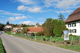
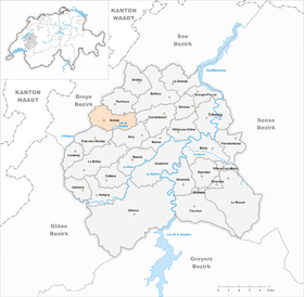
Noréaz lies at 638 m above sea level. M. , 10 km west of the canton capital Friborg (beeline). The farming village extends on a south-sloping slope on the northern edge of the Lac de Seedorf plain , in the Molasse hill country of the Freiburg Central Plateau .
The area of the 6.9 km² former municipal area comprises a section of the Molasse Heights between the Broye plain in the north-west and the Glânetal in the south-east. The community area in the south is part of the up to 1.5 km wide plain of Lac de Seedorf. The Seedorfsee is also completely within the municipality, while only the northern part of the La Goillette pond belongs to Noréaz. To the east, this plain is drained from the Sonnaz to the Saane. Towards the west it drops with a steep slope into the erosion valley of the Arbogne , which forms the western boundary of the municipality.
The high plateau of Noréaz (around 660 m above sea level ), which is bordered by the Forêt de Berley forest and the valley of the Ruisseau des Chaudeires , joins the plain of the Seedorfsee in the north . In the northeast, the municipality also includes the forest heights of Rueyres ( 718 m above sea level ) and Piamont , on the 729 m above sea level. M. the highest point of Noréaz is reached. In 1997, 5% of the municipal area was in settlements, 28% in forests and woodlands, 65% in agriculture and a little less than 2% was unproductive land.
Noréaz includes the hamlets of Seedorf FR ( 622 m above sea level ) on the northern edge of the Seedorf level and at the foot of the Piamont and Echeseby ( 632 m above sea level ) on the Noréaz plateau as well as a few individual farms. Neighboring communities to Noréaz were Ponthaux , Corminboeuf , Avry , Prez-vers-Noréaz and Montagny .
population
Noréaz was one of the small communities in the canton of Friborg. 91.1% of the residents are French-speaking, 6.1% German-speaking and 1.5% speak Portuguese (as of 2000). The population of Noréaz was 455 in 1900. After a peak in 1920 with 641 inhabitants, a decrease of over 35% to 407 people was registered by 1980 due to strong emigration. Since then a slight population growth has been recorded again.
economy
Up until the second half of the 20th century, Noréaz was a predominantly agricultural village. Even today, the have farming , the fruit production , the dairy industry and animal husbandry an important role in the employment structure of the population. Further jobs are available in local small businesses and in the service sector. In the last few decades the village has also developed into a residential community thanks to its attractive location. Many workers are therefore commuters who mainly work in the Freiburg region.
traffic
The community is located off the main thoroughfares on a connecting road from Prez-vers-Noréaz to Grolley . Noréaz is connected to the public transport network by a bus from the Transports publics Fribourgeois , which runs from Freiburg to Nierlet-les-Bois .
history
The first written mention of the place took place in 1134 under the name Noarea . The place name goes back to the Latin word nucariolum (walnut grove ). Since the Middle Ages , Noréaz has belonged to the Montagny domain. The lords of Montagny maintained a castle here. In 1447 the village was cremated by the former in the war between the Freiburgers and the Savoy.
By purchase, Noréaz came under the rule of Freiburg in 1478 and was assigned to the Bailiwick of Montagny. After the collapse of the Ancien Régime (1798), the village belonged to the Payerne district during the Helvetic period , to the Montagny district from 1803 and to the Friborg district from 1815, before it was incorporated into the Saane district in 1848 with the new cantonal constitution.
Attractions
The church of Noréaz was built during the 20th century. Seedorf Castle, a stately mansion on the northern edge of the Seedorf Plain, was built in 1769. Seedorf has housed a vocational training center since 1974.
Web links
- Official website of the municipality of Noréaz
- Marianne Rolle / GL: Noréaz FR. In: Historical Lexicon of Switzerland .
- Aerial views of the village


