
Le Mouret
| Le Mouret | |
|---|---|
 |
|
| State : |
|
| Canton : |
|
| District : | Saane |
| BFS no. : | 2220 |
| Postal code : | 1724 |
| Coordinates : | 579 599 / 177156 |
| Height : | 754 m above sea level M. |
| Height range : | 672–1528 m above sea level M. |
| Area : | 18.56 km² |
| Residents: | 3154 (December 31, 2018) |
| Population density : | 170 inhabitants per km² |
| Website: | www.le-mouret.ch |
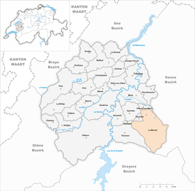
| Location of the municipality | |
  |
|
Le Mouret ( Freiburg Patois ) is a municipality in the District de la Sarine (German: Saanebezirk) in the canton of Friborg in Switzerland . The former German name Muret (for the hamlet Le Mouret) is no longer used today. The municipality was founded on January 1, 2003 as a merger of the former municipalities Bonnefontaine , Essert (FR) , Montévraz , Oberried (FR) , Praroman and Zénauva .
geography
Le Mouret is located at 754 m above sea level. M. , 7 km south of the canton capital Friborg (beeline). The community extends in the valley basin of the Ruisseau du Pontet , in the pre-alpine hill area of the Freiburg Central Plateau , at the northern foot of the Berra ridge . Le Mouret is part of the Freiburg agglomeration , the urban area surrounding the city of Freiburg.
The area of the municipal area of 18.5 km² comprises a section of the higher Freiburg Central Plateau on the northern edge of the Alps. The entire municipality is drained from the Nesslerabach to the Ärgera (French: Gérine). This brook is made up of the water of numerous spring brooks in the Burgerwald on the northern slope of the Petit Cousimbert : from west to east these are the Ruisseau du Pontet , the Dorfbach von Zénauva, the Ruisseau de Montécu and the Rüdigrabenbach (forms the eastern border of the municipality) .
The southern border runs on the ridge between the Petit Cousimbert (at 1530 m above sea level, the highest point of Le Mouret) and the Chrüzflue ( 1263 m above sea level ). The northern slope of this ridge is densely forested ( Burgerwald ) and subdivided by the erosion valleys of the various streams. To the north of the forest slope is a partly wooded, partly covered with meadows and pastures hill zone, which in the Feyla 1086 m above sea level. M. reaches and is again strongly divided by the source streams of the Nesslerabach. Further north follow the up to 1 km wide basin of the Ruisseau du Pontet, the main settlement area of the municipality of Le Mouret, and the meadow height of Praroman ( 791 m above sea level ). To the west, the communal soil extends into a hollow south of the Bois d'Amont and onto the forest hill Bois Derrey ( 886 m above sea level ). In 1997, 7% of the municipal area was in settlements, 43% in forests and woodlands, 49% in agriculture and a little less than 1% was unproductive land.
Le Mouret is a scattered settlement community consisting of a number of villages and hamlets, which before the merger were partially split up by the numerous community boundaries and assigned to different communities:
- Praroman , 779 m above sea level M. , on a hill north of the Ruisseau du Pontet, 1165 inhabitants
- Moulin à Bentz , 740 m above sea level M. , at the Ruisseau du Pontet
- Le Mouret , 754 m above sea level M. , at the Ruisseau du Pontet; the western part of the settlement belongs to the political municipality Ferpicloz
- Le Pafuet , 741 m above sea level M. , in the valley floor south of the Ruisseau du Pontet
- Essert (FR) , 818 m above sea level M. , on the eastern slope of the forest hill Bois Derrey, 259 inhabitants
- Montévraz lingerie , 871 m above sea level M. , at the north foot of the Petit Cousimbert, 529 inhabitants
- Montévraz-Dessus , 908 m above sea level M. , at the north foot of the Petit Cousimbert
- Montembloud , 797 m above sea level M. , on the hill between the Ruisseau du Pontet and the village stream of Zénauva
- Zénauva , 798 m above sea level M. , in the valley of the Dorfbach, 142 inhabitants
- Oberried (FR) , 807 m above sea level M. , on a terrace north of the Feyla, 154 inhabitants
- Montécu , 765 m above sea level M. , on the slope west of the Ruisseau de Montécu
- Bonnefontaine , 766 m above sea level M. , on the slope east of the Ruisseau de Montécu, 507 inhabitants
Furthermore, numerous individual farms and farm settlements belong to Le Mouret. Neighboring municipalities of Le Mouret are Villarsel-sur-Marly , Tentlingen , Sankt Silvester , Plasselb , La Roche , Treyvaux , Senèdes , Ferpicloz and Ependes .

population
With 3,154 inhabitants (as of December 31, 2018), Le Mouret is one of the medium-sized municipalities in the canton of Friborg. 88.3% of the residents are French-speaking, 8.9% German-speaking and 0.9% speak Portuguese (as of 2000). The population of Le Mouret was 1489 inhabitants in 1900 (all former parishes included). In the course of the 20th century, the population fluctuated between 1470 and 1670 people. Since 1970 (1542 inhabitants) there has been a significant increase in population. The main growth is limited to the village of Praroman and the settlement of Le Mouret, while the remaining villages are growing slowly.
economy
Until the second half of the 20th century, Le Mouret was predominantly an agricultural community. In the past, various mills, sawmills and forges were operated along the streams. In the 19th century, straw weaving was widespread. Even today, dairy and cattle breeding and, to a lesser extent, arable farming have a certain place in the income structure of the population.
Numerous other jobs are available in local small businesses and in the service sector. In Le Mouret, in the municipality of Ferpicloz, there had been a brickworks since the 17th century. Today there are larger commercial zones in the valley floor of the Ruisseau du Pontet near Le Mouret and Moulin à Bentz. Mainly companies from the construction and transport industry as well as wood processing, wood construction and IT are represented in the municipality. In the last few decades the village has also developed into a residential community. Many workers are therefore commuters who mainly work in the Freiburg region.
Above Oberried is the Les Peupliers Institute (formerly known as Sonnenwil), which houses an old people's and nursing home and an institution for those who are difficult to educate. The Grande Riedera Castle near Essert serves as a cultural center.
traffic
The community is very well developed in terms of traffic. The Le Mouret settlement is on the main road from Freiburg via La Roche to Bulle . Le Mouret is connected to the public transport network by the Transports publics fribourgeois bus routes , which run from Freiburg via La Roche to Bulle or Jaun and from Freiburg to Bonnefontaine . Essert, Montévraz, Zénauva and Oberried have no direct connection to public transport.
history
In the municipality of Le Mouret had since the Middle Ages , the monastery Hauterive rich land and clearing rights in the woods. Other goods belonged to the Lords of Arconciel, of Ependes and of Marly. In the course of the 15th century, the entire municipality came under the rule of Freiburg and was assigned to the old landscape (Burgpanner). After the collapse of the Ancien Régime (1798), the villages of Le Mouret belonged to the La Roche district during the Helvetic period and to the Friborg district from 1803, before being incorporated into the Saane district in 1848 with the new cantonal constitution.
In 1996 the idea of a large-scale community merger was born. On June 13, 2002, the voters of all municipalities voted for the merger with an average of 75% in favor. With effect from January 1, 2003, the previously independent municipalities Bonnefontaine , Essert (FR) , Montévraz , Oberried (FR) , Praroman and Zénauva were merged. The new community was named Le Mouret after the industrial estate in which Praroman, Zénauva, Essert and Ferpicloz had a share. The latter also participated in the merger project at the beginning, but left it later and still forms an independent community today. Even before the merger, the name Le Mouret stood for various inter-municipal organizations and sports clubs.
Attractions
Web links
- Official website of the municipality of Le Mouret (French)
- Aerial views of Le Mouret
- Marianne Rolle: Bonnefontaine. In: Historical Lexicon of Switzerland .
- Marianne Rolle: Essert. In: Historical Lexicon of Switzerland .
Individual evidence
- ↑ Permanent and non-permanent resident population by year, canton, district, municipality, population type and gender (permanent resident population). In: bfs. admin.ch . Federal Statistical Office (FSO), August 31, 2019, accessed on December 22, 2019 .
Arconciel | Autigny | Avry | Belfaux | Chénens | Corminboeuf | Cottens | Ependes | Ferpicloz | Freiburg | Gibloux | Givisiez | Granges-Paccot | Grolley | Hauterive | La Brillaz | La Sonnaz | Le Mouret | Marly | Matran | Neyruz | Pierrafortscha | Ponthaux | Prez | Senèdes | Treyvaux | Villarsel-sur-Marly | Villars-sur-Glâne
Former parishes: Autafond | Avry-sur-Matran | Bonnefontaine | Chésalles | Chésopelloz | Cormagens | Corpataux | Corpataux-Magnedens | Corsalettes | Corserey | Corjolens | Cutterwil | Ecuvillens | Essert | Estavayer-le-Gibloux | Farvagny | Farvagny-le-Grand | Farvagny-le-Petit | Formangueires | Grenilles | Illens | La Corbaz | Le Glèbe | Lentigny | Lossy | Lossy Formangueires | Lovens | Magnedens | Marly-le-Grand | Marly-le-Petit | Montécu | Montévraz | Nierlet-les-Bois | Noréaz | Oberried | Onnens | Posat | Posieux | Prelude | Prez-vers-Noréaz | Rossens | Rueyres-Saint-Laurent | Sales | Villarlod | Villarsel-le-Gibloux | Vuisternens-en-Ogoz | Zénauva
Canton of Friborg | Districts of the canton of Friborg | Municipalities of the canton of Friborg