Le Glèbe
| Le Glèbe | ||
|---|---|---|
| State : |
|
|
| Canton : |
|
|
| District : | Saane | |
| Municipality : | Gibloux | |
| Postal code : | 1695 | |
| former BFS no. : | 2223 | |
| UN / LOCODE : | CH ELB (Estavayer-le-Gibloux) | |
| Coordinates : | 568399 / 174611 | |
| Height : | 756 m above sea level M. | |
| Area : | 10.31 km² | |
| Residents: | 1246 (December 31, 2014) | |
| Population density : | 121 inhabitants per km² | |
| Website: | commune-gibloux.ch | |
|
Village center of Rueyres-Saint-Laurent, municipality of Le Glèbe |
||
| map | ||
|
|
||
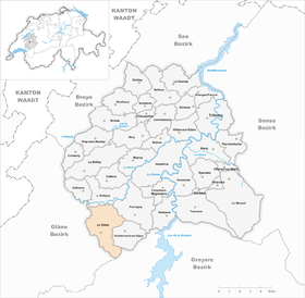
Until December 31, 2015, Le Glèbe was a political municipality in the District de la Sarine (German: Saanebezirk) in the canton of Friborg in Switzerland . The municipality was formed on January 1, 2003 from the merger of the former municipalities Estavayer-le-Gibloux , Rueyres-Saint-Laurent , Villarlod and Villarsel-le-Gibloux . On January 1, 2016, Le Glèbe merged with the municipalities of Corpataux-Magnedens , Farvagny , Rossens and Vuisternens-en-Ogoz to form the new municipality of Gibloux .
geography
Le Glèbe is 700 to 800 m above sea level. M. , 14 km southwest of the canton capital Friborg (linear distance). The community stretches on both sides of the Le Glèbe creek south of the Glâne valley , at the northern foot of Mont Gibloux , in the Molasse hills of the Freiburg Central Plateau .
The area of the 10.3 km² former municipal area comprises a section of the gently undulating Molasse hill country south of the Glâne valley. The area is drained by the Glèbe brook , which is slightly cut into the molasse layers in the area. In the far north, the former municipal area extends to the course of the Glâne. From here it extends southwards over an adjacent plateau, which is bordered in the west by the hill of the Bois de Vernex ( 725 m above sea level ) and in the east by the Longivue stream . The community spell extends further south over the relatively gently rising slopes of Villarlod (in the Faita 810 m above sea level ) west and Rueyres-Saint-Laurent (on the Chapy 851 m above sea level ) east of the Glèbe. A narrow tip extends in the south along the valley basin of the Glèbe up to the forest ridge of the Gibloux, on which at 1204 m above sea level. M. the highest point of Le Glèbe is reached. The eastern part of the headwaters of the Glèbe belongs to the municipality. In 1997, 7% of the former municipal area was accounted for by settlements, 20% for forests and woodlands and 73% for agriculture.
Le Glèbe consists of the districts Estavayer-le-Gibloux ( 700 m above sea level ), Rueyres-Saint-Laurent ( 756 m above sea level ), Villarsel-le-Gibloux ( 748 m above sea level ) and Villarlod ( 800 m above sea level ). In addition, numerous individual farms and some holiday homes belong to the former community. Neighboring communities of Le Glèbe were Autigny , Farvagny , Vuisternens-en-Ogoz , Pont-en-Ogoz , Sorens and Villorsonnens .
population
With 1246 inhabitants (as of December 31, 2014), Le Glèbe was one of the medium-sized municipalities in the canton of Friborg. 92.4% of the residents are French-speaking, 3.5% German-speaking and 2.5% speak Portuguese (as of 2000). The population of Le Glèbe was 937 in 1900. After a peak in 1910 with 962 inhabitants, the population decreased by almost 40% to 593 people by 1970. Since then, there has been a significant increase in population again, especially during the 1990s.
economy
Until the second half of the 20th century, Le Glèbe was mainly an agricultural village. Agriculture , dairy farming and cattle breeding still play an important role in the income structure of the population today . Other jobs are available in local small businesses and in the service sector, including in companies in the construction industry, wood processing and IT. Several gravel pits are being exploited near Estavayer-le-Gibloux. In the last few decades the village has also developed into a residential community. Many workers are therefore commuters who mainly work in the Freiburg region.
traffic
The former municipality is located off the major thoroughfares on various connecting roads from Farvagny to Romont and Villorsonnens . The closest connection to the A12 motorway (Bern-Vevey) is around 5 km from the community. The municipality is connected to the public transport network by the two bus routes of the Transports publics fribourgeois (Romont - Farvagny, Freiburg - Rueyres-Saint-Laurent ) and by a post bus line (Cottens - Villarsel-le-Gibloux).
history
The municipality of Le Glèbe was settled very early. The remains of a Roman villa were found near Estavayer-le-Gibloux . During the Middle Ages , the localities of Le Glèbe belonged to the Pont dominion. In 1483 the villages came under the rule of Freiburg and were assigned to the Vogtei Pont-Farvagny. After the collapse of the Ancien Régime (1798), the villages of Le Glèbe belonged to the Romont district during the Helvetic period and to the Farvagny district from 1803, before being incorporated into the Saane district in 1848 with the new cantonal constitution. The parish church of the area is in Estavayer-le-Gibloux.
As part of the community mergers supported by the canton of Friborg since 2000, the residents of Estavayer-le-Gibloux , Rueyres-Saint-Laurent , Villarlod and Villarsel-le-Gibloux decided in 2002 to merge their communities. With effect from January 1, 2003, the merger of the villages to form the new municipality with the name Le Glèbe came into force.
Attractions
Web links
- Official website of the municipality of Le Glèbe (French)
- Marianne Rolle: Estavayer-le-Gibloux. In: Historical Lexicon of Switzerland .


