
Treyvaux
| Treyvaux | |
|---|---|
 |
|
| State : |
|
| Canton : |
|
| District : | Saane |
| BFS no. : | 2226 |
| Postal code : | 1733 |
| Coordinates : | 576 980 / 175 158 |
| Height : | 770 m above sea level M. |
| Height range : | 596–1514 m above sea level M. |
| Area : | 11.40 km² |
| Residents: | 1470 (December 31, 2018) |
| Population density : | 129 inhabitants per km² |
| Website: | www.treyvaux.ch |
 Village center |
|
| Location of the municipality | |
  |
|
Treyvaux ( Freiburger Patois ) is a municipality in the District de la Sarine (German: Saanebezirk) in the canton of Friborg in Switzerland . The former German name Treffels is no longer used today.
geography
Treyvaux is 770 m above sea level. M. , 9 km south of the canton capital Friborg (beeline). The village extends in a valley north of the La Combe forest heights , in the pre-alpine hill zone of the Freiburg Central Plateau .
The area of the 11.4 km² municipal area comprises a section of the pre-alpine hilly landscape east of the Saanegraben . The western border forms the strongly meandering river course of the Saane below the Lac de la Gruyère , which is cut deep into the molasse layers of the area. The approximately 200 m wide flat valley floor is predominantly forested. This is followed by a steep slope up to 100 m high, formed over long stretches of sandstone cliffs , which merges further east into the pre-alpine hill country.
The western part of the municipality, which is drained directly to the Saane, is bounded in the north by the village stream of Senèdes and in the south by the Ruisseau de la Verasse , both of which have created a deep ditch in the lower part due to erosion . In the middle is the wide basin of the village stream of Treyvaux, which from the heights Gros Bugnon ( 837 m above sea level ) and Chênes d'Essert ( 890 m above sea level ) and La Combe ( 1082 m above sea level) is located. ) is flanked.
Further to the east, the municipality extends in a relatively narrow corner over a saddle into the valley of the Ruisseau du Pontet , the water of which is led over the Nesslerabach to the Ärgera (French: Gérine) and then to the Saane. To the east of this valley are the forest height Mondzemolien and the mountain ridge of the Petit Cousimbert , on which at 1530 m above sea level. M. the highest point of Treyvaux is reached. The forest area Joux de Treyvaux in the headwaters of the Ruisseau du Pontet on the northwest slope of the Petit Cousimbert also belongs to the municipality. In 1997, 6% of the municipal area was in settlements, 30% in forests and woodlands, 63% in agriculture and around 1% was unproductive land.
Treyvaux includes the hamlets of Le Plan ( 773 m above sea level ) on a ledge above the Saanegraben, Pratzey ( 794 m above sea level ) on the Ruisseau du Pontet at the eastern foot of La Combe, and numerous individual farms spread across the area. Neighboring municipalities of Treyvaux are Arconciel , Senèdes , Le Mouret , La Roche , Pont-la-Ville and Gibloux .
population
With 1470 inhabitants (as of December 31, 2018), Treyvaux is one of the medium-sized municipalities in the canton of Friborg. 93.4% of the residents are French-speaking, 3.3% German-speaking and 1.8% speak Portuguese (as of 2000). The population of Treyvaux was 1063 in 1900. In the course of the 20th century, the population fluctuated between 920 and 1050 inhabitants. Only since 1980 (937 inhabitants) has a significant increase in population been recorded.
economy
Until the second half of the 20th century, Treyvaux was predominantly an agricultural village. Even today, dairy farming and cattle breeding and, to a lesser extent, arable farming play an important role in the income structure of the population. Numerous other jobs are available in local small businesses and in the service sector. The industrial sector in Treyvaux focuses on a large joinery, a sawmill, precision engineering workshops and the construction industry. The Landi is also represented in the community. If the snow conditions are good, a ski lift is operated above the village on the northern slope of La Combe. In the last few decades the village has developed into a residential community. Many workers are therefore commuters who mainly work in the Freiburg region.
traffic
The community is very well developed in terms of traffic, although it is located off the main thoroughfares on a connecting road from Rossens to Le Mouret . The closest connection to the A12 motorway (Bern-Vevey) is around 5 km from the town center. The village is connected to the public transport network by the Transports publics Fribourgeois bus routes , which run from Freiburg to Bulle or Jaun .
history
The first written mention of the place took place in 1169 under the name Tribus Vallibus . Many other names appeared later: Treyvaul , Treyvas , Trevas (in the 13th century), Tresvaux (1235), Trevaux (1246), Tresvald , Tresvals , Treswels (1260), Trevauz (1378), Trevaul , Trevaulx and Trevaut (1423) and Treyvaula and Treyvaux (1453). Tribus Vallibus has roughly the meaning of a place with three valleys. This name, which has been transformed into Latin, is linguistic, since Treyvaux rightly means about as much as place on the other side of the valley .
Treyvaux has been under the rule of Arconciel-Illens since the Middle Ages . After the Bernese and Friborgs had conquered this rule in 1475, it was dissolved in 1484 and Treyvaux was assigned to the Bailiwick of Illens. After the collapse of the Ancien Régime (1798), the village belonged to the La Roche district during the Helvetic Republic and from 1803 to the Friborg district before it was incorporated into the Saane district in 1848 with the new cantonal constitution.
Attractions
The parish of Treyvaux is one of the oldest in the region. It probably existed before the 10th century and came under the care of the Hauterive Monastery in 1173 . The original parish church was today's Saint-Pierre chapel on a ledge above the Saane. Towards the end of the 13th century, the Sainte-Marie church was built in the village and made the new parish church. The church was given its present form when it was rebuilt in 1871.
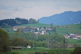
View of Treyvaux from the entrance to Farvagny
_091.JPG)
people
- Joseph Yerly , writers frankoprovenzalischer Language ( 1896 - 1961 )
Web links
- Official website of the municipality of Treyvaux (French)
- Aerial views of the village
- Marianne Rolle / CBA: Treyvaux. In: Historical Lexicon of Switzerland .
Individual evidence
- ↑ Permanent and non-permanent resident population by year, canton, district, municipality, population type and gender (permanent resident population). In: bfs. admin.ch . Federal Statistical Office (FSO), August 31, 2019, accessed on December 22, 2019 .
Arconciel | Autigny | Avry | Belfaux | Chénens | Corminboeuf | Cottens | Ependes | Ferpicloz | Freiburg | Gibloux | Givisiez | Granges-Paccot | Grolley | Hauterive | La Brillaz | La Sonnaz | Le Mouret | Marly | Matran | Neyruz | Pierrafortscha | Ponthaux | Prez | Senèdes | Treyvaux | Villarsel-sur-Marly | Villars-sur-Glâne
Former parishes: Autafond | Avry-sur-Matran | Bonnefontaine | Chésalles | Chésopelloz | Cormagens | Corpataux | Corpataux-Magnedens | Corsalettes | Corserey | Corjolens | Cutterwil | Ecuvillens | Essert | Estavayer-le-Gibloux | Farvagny | Farvagny-le-Grand | Farvagny-le-Petit | Formangueires | Grenilles | Illens | La Corbaz | Le Glèbe | Lentigny | Lossy | Lossy Formangueires | Lovens | Magnedens | Marly-le-Grand | Marly-le-Petit | Montécu | Montévraz | Nierlet-les-Bois | Noréaz | Oberried | Onnens | Posat | Posieux | Prelude | Prez-vers-Noréaz | Rossens | Rueyres-Saint-Laurent | Sales | Villarlod | Villarsel-le-Gibloux | Vuisternens-en-Ogoz | Zénauva
Canton of Friborg | Districts of the canton of Friborg | Municipalities of the canton of Friborg