
Pont-la-Ville FR
| FR is the abbreviation for the canton of Friborg in Switzerland and is used to avoid confusion with other entries of the name Pont-la-Ville . |
| Pont-la-Ville | |
|---|---|
 |
|
| State : |
|
| Canton : |
|
| District : | Gruyère |
| BFS no. : | 2147 |
| Postal code : | 1649 |
| Coordinates : | 574 950 / 172 140 |
| Height : | 746 m above sea level M. |
| Height range : | 607–896 m above sea level M. |
| Area : | 4.35 km² |
| Residents: | 601 (December 31, 2018) |
| Population density : | 138 inhabitants per km² |
| Website: | www.pont-la-ville.ch |
| Location of the municipality | |
  |
|
Pont-la-Ville ( Freiburg Patois ) is a municipality in the Gruyère district of the canton of Friborg in Switzerland . The former German name Ponnendorf is no longer used today.
geography
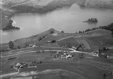
Pont-la-Ville is 746 m above sea level. M. , 10 km north-northeast of the district capital Bulle (linear distance). The village extends on a terrace in a panoramic location around 70 m above the eastern shore of Lake Gruyère , on the northern edge of the Alps between the heights of Gibloux in the west and Berra in the east.
The area of the community area of 4.3 km² (with lake portion 5.5 km²) comprises a section of the pre-alpine landscape at the foot of the Berra. The western border forms the Gruyère lake, whereby the border does not run in the middle of the reservoir, but along the meander of the Saane (French: Sarine) sunk in the water . In the south, the valley of the Serbache brook, which is also sunk in the dammed water, forms the natural boundary. The lakeshore is only relatively flat in the area below the village of Pont-la-Ville, otherwise it has steep forest and sometimes rocky slopes. To the east, the municipality extends to the height of Vers les Châteaux ( 878 m above sea level. M. ) and on the slope of the hill La Combe . Here with 892 m above sea level. M. reached the highest point of Pont-la-Ville. To the north the area extends to the dam of the Lac de la Gruyère and into the valley of the Saane, cut deep into the molasse layers . The northern border runs along its side brook Ruisseau de la Verasse, which rises on the hill La Combe . In 1997, 11% of the municipal area was in settlements, 16% in forests and woodlands, 72% in agriculture and a little less than 1% was unproductive land.
Pont-la-Ville includes the Sur Momont housing estate ( 735 m above sea level ) on the plateau of the peninsula between the Lac de la Gruyère and the tributary of the Serbache, as well as numerous individual farms. Neighboring municipalities to Pont-la-Ville are La Roche , Hauteville , Pont-en-Ogoz , Gibloux and Treyvaux .
population
With 601 inhabitants (as of December 31, 2018), Pont-la-Ville is one of the smaller communities in the canton of Friborg. 92.4% of the residents are French-speaking, 4.6% German-speaking and 0.9% Portuguese-speaking (as of 2000). The population of Pont-la-Ville was 471 in 1900. After that, the population decreased by more than 40% to 270 people by 1970 due to strong emigration. Since then, the population has grown rapidly again.
economy
Until the second half of the 20th century, Pont-la-Ville was a predominantly agricultural village. Even today, livestock and dairy farming and, to a lesser extent, arable farming play an important role in the income structure of the population. Further jobs are available in local small businesses and in the service sector. Pont-la-Ville has a golf course with a hotel. In the last few decades the village has developed into a residential community thanks to its attractive location. Many people in employment are therefore commuters who work in the Bulle and Freiburg regions.
traffic
The community is located off the main thoroughfares on a connecting road from Rossens to La Roche . The next connection to the A12 motorway , which has been open continuously from Bern to Vevey since 1981 , is around 6 km from the town center. The village is connected to the public transport network by the Transports publics Fribourgeois bus route from La Roche to Pont-la-Ville.
history
The municipality of Pont-la-Ville was already settled in Roman times. Remains of a Roman building and a druid stone were found. The place was first mentioned in a document in 1228 under the name Pont la vila , derived from the Latin word pons (bridge).
Since the Middle Ages, Pont-la-Ville has been under the authority of the Bishop of Lausanne . Below the village there was initially a wooden bridge, and from 1544 a stone arch bridge (Pont de Thusy) over the Saane. This bridge was flooded when the Lac de la Gruyère was dammed in 1948. After the conquest of the Vaud by Bern, Pont-la-Ville came under the rule of Friborg as a former episcopal area in 1537 and, together with the neighboring village of La Roche, was allocated as an exclave of the Bailiwick of Bulle. After the collapse of the Ancien Régime (1798), Pont-la-Ville belonged to the Bulle district during the Helvetic and the subsequent period until 1848 before it was incorporated into the Gruyères district.
Attractions
The church of Pont-la-Ville in its present form dates from the 19th century. There is a chapel on the lake shore.
Web links
- Official website of the municipality of Pont-la-Ville (French)
- Marianne Rolle: Pont-la-Ville. In: Historical Lexicon of Switzerland .
- Aerial views of the village
Individual evidence
- ↑ Permanent and non-permanent resident population by year, canton, district, municipality, population type and gender (permanent resident population). In: bfs. admin.ch . Federal Statistical Office (FSO), August 31, 2019, accessed on December 22, 2019 .
Bas-Intyamon | Botterens | Broc | Bull | Châtel-sur-Montsalvens | Corbières | Crésuz | Echarlens | Grandvillard | Gruyères | Hauteville | Haut-Intyamon | Jaun | La Roche | Le Pâquier | Marsens | Morlon | Pont-en-Ogoz | Pont-la-Ville | Riaz | Sâles | Sorens | Val-de-Charmey | Vaulruz | Vuadens
Former municipalities: Albeuve | Avry-devant-Pont | Cerniat | Charmey | Enney | Estavannens | Gumefens | La Tour-de-Trême | Le Bry | Lessoc | Maules | Montbovon | Neirivue | Romance | Rueyres-Treyfayes | Villarbeney | Villars-d'Avry | Villars-sous-Mont | Villarvolard | Vuippens
Canton of Friborg | Districts of the canton of Friborg | Municipalities of the canton of Friborg