
Broc FR
| FR is the abbreviation for the canton of Friborg in Switzerland and is used to avoid confusion with other entries of the name Broc . |
| Broc | |
|---|---|
 |
|
| State : |
|
| Canton : |
|
| District : | Gruyère |
| BFS no. : | 2124 |
| Postal code : | 1636 |
| UN / LOCODE : | CH BRC |
| Coordinates : | 573.99 thousand / 161 398 |
| Height : | 718 m above sea level M. |
| Height range : | 674–1827 m above sea level M. |
| Area : | 10.03 km² |
| Residents: | 2651 (December 31, 2018) |
| Population density : | 264 inhabitants per km² |
| Website: | www.broc.ch |
 Broc-Fabrique: Nestlé / Cailler premises |
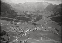
|
| Location of the municipality | |
  |
|
Broc ([ bʀɔ: ], Freiburger Patois ) is a municipality in the Gruyère district of the canton of Friborg in Switzerland . The former German name Bruck is no longer used today.
geography
Broc is 718 m above sea level. M. , 3.5 km east-southeast of the district capital Bulle (linear distance). The village extends on the high terrace between the rivers Saane (French: Sarine) in the west and Jaunbach (French: Jogne) in the east, south of Lake Gruyère , on the northern edge of the Alps.
The area of the 10.1 km² municipal area covers a section of the pre-alpine area in the Gruyère region. The Saane forms the western border. From here, the municipality extends eastward over the flat valley floor and the gravel terrace from Broc into the valley of the Jaunbach. This flows between the Lac de Montsalvens reservoir (a small part is part of the municipal area) and Broc through a deeply cut rock gorge ( Gorges de la Jogne ). South of this valley, the slope covered by meadows and forests rises steeply to the summit of Dent de Broc , which is 1,829 m above sea level. M. represents the highest point of Broc. The southern municipal boundary runs along the Dent de Broc ridge, which extends from the Saane to the Motélon Valley. In the far north-west the area extends to the mouth of the Saane in the Gruyère lake and in the alder forest in the estuary. In 1997, 9% of the municipal area was in settlements, 43% in forests and woodlands, 43% in agriculture and slightly more than 5% was unproductive land.
Broc includes the industrial estate Broc-Fabrique ( 685 m above sea level ) on the Jaunbach and some individual farms on the northern slope of the Dent de Broc. The neighboring municipalities of Broc are Bulle , Morlon , Botterens , Châtel-sur-Montsalvens , Crésuz , Val-de-Charmey and Gruyères .
population
With 2,651 inhabitants (as of December 31, 2018) Broc is one of the medium-sized municipalities in the canton of Friborg. 88.3% of the residents are French-speaking, 2.9% Portuguese-speaking and 2.6% German-speaking (as of 2000). The population of Broc was 406 in 1850 and 628 in 1900. After that, it rose by more than 1000 people within a decade (1910 1708 inhabitants) and reached its peak around 1920 with 2163 inhabitants. After a decline of almost 30% to 1,552 people by 1950, the population has continued to grow since then.
economy
Broc was a predominantly agricultural village until the end of the 19th century . In addition, straw weaving played an important role, although it fell sharply towards the end of the 19th century. The establishment of the Cailler chocolate factory in 1898 put an end to unemployment in the village. The factory quickly became the most important employer in the region, which was reflected in the rapid population growth of Broc in the first decade of the 20th century. In 1930 almost 1,800 workers were employed in the Cailler factory.
Today Broc still offers around 900 jobs. With 3% of the gainfully employed who are still employed in the primary sector, agriculture only has a minor role in the employment structure of the population. Around 62% of the workforce is employed in the industrial sector, while the service sector accounts for 35% of the workforce (as of 2001).
Agriculture focuses on livestock and dairy farming . In addition to the chocolate factory, which is now part of Nestlé , the most important industrial companies include a plastic injection molding factory, two furniture factories, a joinery, an electricity company and construction and transport companies. In 2013 the Maison Cailler counted 368,000 visitors from all over the world.
In the last few decades the village has developed into a residential community. Many people in employment are therefore commuters who work in the Bulle or Freiburg regions.
traffic
The community is very well developed in terms of traffic. It is located on the main road from Bulle over the Jaunpass to Boltigen . From here the connecting road branches off at Broc, which leads east of Lake Gruyère to Freiburg . On June 24, 1912, the railway line from Bulle to Broc (for the development of the factory area) was put into operation. The transports publics Fribourgeois bus routes from Bulle to Boltigen and Corbières , which operate via Broc, provide for the fine distribution of public transport .
history
Traces of settlement from the Middle Bronze Age and a burial ground from the La Tène period were found in the municipality of Broc . The first written mention of the place took place in 1115 under the names Broyc and Broch ; The name Broz has been handed down from 1285 . The place name goes back to the old French word broc , which means rock spur , rock ridge .
Broc had been owned by the noble family of the same name since the 12th century, which died out in the mid-14th century and was probably a branch line of the Counts of Gruyères . The village then came into the possession of Montsalvens, a fief of the county of Gruyères. In the early 13th century, a Benedictine priory was founded near the Saane , which initially belonged to the Lutry monastery and in 1577 came into the possession of the St. Nicholas chapter in Freiburg.
With the Kastlanei Montsalvens Broc came to Freiburg in 1555 and was incorporated into the Bailiwick of Gruyères. After the collapse of the Ancien Régime (1798), the village belonged to the Gruyères prefecture during the Helvetic period and to the Gruyère district since 1848 . In 1890 numerous houses fell victim to a fire.
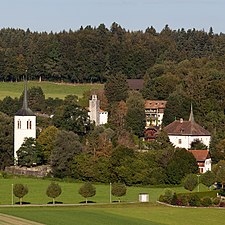
Attractions
On the right bank of the Saane is the Château d'En-Bas (Lower Castle), a large square building from the 12th century (since then it has been restored and redesigned several times, the last time in 1972) and the former seat of the Lords of Broc and of Montsalvens. The castle has cross-frame windows from the 14th century, interior decorations from the Renaissance period and a knight's hall designed in the 17th century . At the castle there is an old stone bridge over the Saane (built in 1580). There is also a tower from the 17th century near the castle, which belonged to the former priory church (church and convent building no longer exist today). The village church of Saint-Blaise was rebuilt in 1877 after a fire.
South of Broc, at the foot of the Dent de Broc, is the Notre-Dame des Marches chapel (rebuilt in 1705), which was previously an important pilgrimage chapel. On the forest hill north of the Jaunbach valley are the ruins of Montsalvens Castle, built in the 12th century. The castle, of which the walls of the striking keep are still preserved, was abandoned in 1671.
The museum of the chocolate manufacturer Cailler, which opened in 2010, is popular; Visitors learn about the history of the Cailler brand and how the company, founded in 1819, changed the way chocolate is made several times. The lifelike staging of the world of cocoa leads visitors from the temples of the Aztecs through the centuries to the surrounding Gruyère region in Switzerland. The museum is the most visited tourist attraction in French-speaking Switzerland . In 2014, over 400,000 people visited the world of chocolate.
Impressions

Broc village
Broc en Bas
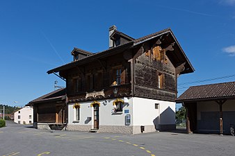
railway station

Local government

Rue du Bourg de l'Auge

school

gym

Place du Parc
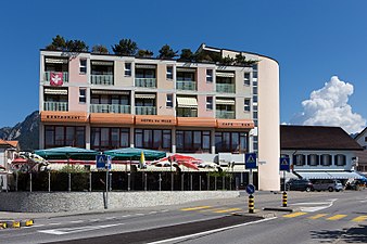
Restaurant, Hotel de Ville

Rue du Bourg de l'Auge


Web links
- Official website of the municipality of Broc (French)
- Marianne Rolle: Broc. In: Historical Lexicon of Switzerland .
- Aerial views of the village
Individual evidence
- ↑ Permanent and non-permanent resident population by year, canton, district, municipality, population type and gender (permanent resident population). In: bfs. admin.ch . Federal Statistical Office (FSO), August 31, 2019, accessed on December 22, 2019 .
- ^ Reto E. Wild: Travel destination Switzerland. Migros Magazin, Zurich July 13, 2015, page 8
Bas-Intyamon | Botterens | Broc | Bull | Châtel-sur-Montsalvens | Corbières | Crésuz | Echarlens | Grandvillard | Gruyères | Hauteville | Haut-Intyamon | Jaun | La Roche | Le Pâquier | Marsens | Morlon | Pont-en-Ogoz | Pont-la-Ville | Riaz | Sâles | Sorens | Val-de-Charmey | Vaulruz | Vuadens
Former municipalities: Albeuve | Avry-devant-Pont | Cerniat | Charmey | Enney | Estavannens | Gumefens | La Tour-de-Trême | Le Bry | Lessoc | Maules | Montbovon | Neirivue | Romance | Rueyres-Treyfayes | Villarbeney | Villars-d'Avry | Villars-sous-Mont | Villarvolard | Vuippens
Canton of Friborg | Districts of the canton of Friborg | Municipalities of the canton of Friborg