
Vaulruz
| Vaulruz | |
|---|---|
 |
|
| State : |
|
| Canton : |
|
| District : | Gruyère |
| BFS no. : | 2155 |
| Postal code : | 1627 |
| Coordinates : | 565 573 / 163 324 |
| Height : | 820 m above sea level M. |
| Height range : | 782–1352 m above sea level M. |
| Area : | 10.10 km² |
| Residents: | 1063 (December 31, 2018) |
| Population density : | 105 inhabitants per km² |
| Website: | www.vaulruz.ch |
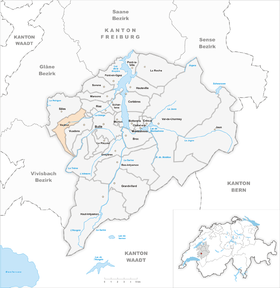
 Vaulruz |
|
| Location of the municipality | |
  |
|
Vaulruz ( Freiburger Patois ) is a municipality in the Gruyère district of the canton of Friborg in Switzerland . The former German name Thalbach is no longer used today.
geography
Vaulruz is 820 m above sea level. M. , 5 km west of the district capital Bulle (linear distance). The former street line village extends on both sides of the Sionge stream , on the northern edge of the Alps on the wide saddle between the range of hills of Mont Gibloux and the pre-alpine forest heights of Les Alpettes north of the Moléson .
The area of the 10.1 km² municipal area comprises a section of the southern higher Freiburg Central Plateau and the adjacent pre-Alps. The central part of the area is taken up by the wide basin of the Sionge and its southern side stream Diron . The plateau of Les Ponts (up to 860 m above sea level ) is located between the two parallel streams . In the north-east, the municipality extends to the southern foothills of Mont Gibloux and reaches 1060 m above sea level on the Joux de Pra Fillieux forest . M .; the northern border is the Ruisseau de Létivan stream . To the south the municipal area extends over a very narrow corner in the headwaters of Dixon and the wooded ridge of here Les Alpettes (with 1355 m above sea level. M. highest elevation of Vaulruz) up to the upper reaches of the Trême . In 1997, 8% of the municipal area was in settlements, 26% in forests and woodlands, 65% in agriculture and a little less than 1% was unproductive land.
The hamlets of Les Ponts-d'Avau ( 852 m above sea level ) and Les Ponts-d'Amont ( 867 m above sea level ) on the plateau between Sionge and Diron belong to Vaulruz, part of the houses of La Sionge ( 835 m above sea level ) in the valley of the stream of the same name as well as numerous individual farms. Vaulruz's neighboring municipalities are Sâles , Riaz , Vuadens , Gruyères and Semsales .
population
With 1,063 inhabitants (as of December 31, 2018), Vaulruz is one of the smaller communities in the canton of Friborg. 96.3% of the residents are French-speaking, 2.4% German-speaking and 0.8% Portuguese-speaking (as of 2000). The population of Vaulruz was 721 in 1900. After a population increase up to 1930 (813 inhabitants) followed by 1970 a decrease to 647 inhabitants. Since then, the population has increased significantly again.
economy
Until the second half of the 20th century, Vaulruz was predominantly an agricultural village. Even today, livestock and dairy farming and, to a lesser extent, arable farming play an important role in the income structure of the population. Further jobs are available in local small businesses and in the service sector. Thanks to its proximity to the A12 motorway, a small commercial zone has been created since the 1990s. Vaulruz is the location of the A12 motorway maintenance depot. In the last few decades the village has also developed into a residential community. Many people in employment are therefore commuters who work in the regions of Bulle, Freiburg and Vevey-Montreux.
traffic
The community is very well developed in terms of transport. It lies on the main road from Bulle to Vevey , from which the roads to Romont and Oron-la-Ville branch off to the west of the village . The next connection to the A12 motorway , which has been open continuously from Bern to Vevey since 1981 and crosses the municipality, is around 1.5 km from the town center.
On July 1, 1868, the railway line from Romont to Bulle was inaugurated with a train station in Vaulruz. The narrow-gauge railway line from Bulle to Châtel-Saint-Denis , which has two stops in the municipality, was put into operation on July 23, 1903.
history

The first written mention of the place took place in 1115 under the name Valle Rodulphi . In 1359 the earlier German place name Mühlsteingrube appeared , a translation of Molaris de Vaulruz , derived from the Latin word molaris (millstone). The German name was later changed to Thalbach .
The Lords of Blonay founded a castle near Vaulruz in the 12th century, which came under the sovereignty of the Savoy in the middle of the 13th century and was greatly expanded. In the early 14th century, the Savoyers founded the fortified settlement of Vaulruz, southwest of the castle, which was granted town charter as early as 1321. But the town soon began to decline with the first plague in 1350 and a fire in the village in 1387. The Savoy residents then sold Vaulruz to the Champion family, who originally came from Saint-Michel-de-Maurienne . From then on the representatives of the noble Champion family, who also had good relations with Freiburg, were Lords of Vaulruz. In addition to Vaulruz, the rule also included the villages of Sâles, Maules and Romanens. Because the Champion family was a citizen of the city of Friborg, Vaulruz was not captured by the Bernese in 1536 when they conquered the Vaud region.
The rule was sold to Freiburg in 1538, which set up the Bailiwick of Vaulruz (with the same boundaries as the rule had before). After the collapse of the Ancien Régime (1798), Vaulruz belonged to the then Bulle district during the Helvetic and the subsequent period until 1848, before it was incorporated into the Gruyères district.
Attractions

Vaulruz Castle stands on a ledge over the Sionge Valley. With its almost square floor plan, it originally dates from the 13th century. One of the oldest parts is the massive square tower in the northeast corner, probably the former keep. The residential buildings along the south wall are more recent and were built in the 16th century. The first church of Sainte-Marguerite was built in the early 14th century; the current building dates from 1819.
The chapel of St. Protasius used to be used for eye problems.
Web links
- Official website of the municipality of Vaulruz (French)
- François Genoud: Vaulruz. In: Historical Lexicon of Switzerland .
- Aerial views of the village
Individual evidence
- ↑ Permanent and non-permanent resident population by year, canton, district, municipality, population type and gender (permanent resident population). In: bfs. admin.ch . Federal Statistical Office (FSO), August 31, 2019, accessed on December 22, 2019 .
Bas-Intyamon | Botterens | Broc | Bull | Châtel-sur-Montsalvens | Corbières | Crésuz | Echarlens | Grandvillard | Gruyères | Hauteville | Haut-Intyamon | Jaun | La Roche | Le Pâquier | Marsens | Morlon | Pont-en-Ogoz | Pont-la-Ville | Riaz | Sâles | Sorens | Val-de-Charmey | Vaulruz | Vuadens
Former municipalities: Albeuve | Avry-devant-Pont | Cerniat | Charmey | Enney | Estavannens | Gumefens | La Tour-de-Trême | Le Bry | Lessoc | Maules | Montbovon | Neirivue | Romance | Rueyres-Treyfayes | Villarbeney | Villars-d'Avry | Villars-sous-Mont | Villarvolard | Vuippens
Canton of Friborg | Districts of the canton of Friborg | Municipalities of the canton of Friborg