
Vuisternens-en-Ogoz
| Vuisternens-en-Ogoz | ||
|---|---|---|
 |
||
| State : |
|
|
| Canton : |
|
|
| District : | Saane | |
| Municipality : | Gibloux | |
| Postal code : | 1696 | |
| former BFS no. : | 2231 | |
| Coordinates : | 570 493 / 173 025 | |
| Height : | 800 m above sea level M. | |
| Area : | 6.24 km² | |
| Residents: | 975 (December 31, 2014) | |
| Population density : | 156 inhabitants per km² | |
| Website: | commune-gibloux.ch | |
_126.JPG) Vuisternens-en-Ogoz |
||
| map | ||
|
||


Vuisternens-en-Ogoz ( Freiburger Patois ) was a political municipality in the District de la Sarine (German: Saanebezirk) of the canton of Friborg in Switzerland until December 31, 2015 . The former German place name Winterlingen in Ogoz is no longer used today. On January 1, 2016, Vuisternens-en-Ogoz merged with the municipalities of Corpataux-Magnedens , Farvagny , Le Glèbe and Rossens to form the new municipality of Gibloux .
geography
Vuisternens-en-Ogoz lies at 800 m above sea level. M. , 13 kilometers southwest of the canton capital Friborg (beeline), in the Ogoz region. The village extends in the hollow of a source brook of the Longivue at the northern foot of Mont Gibloux , west of the Lac de la Gruyère , in the Molasse hill country of the Freiburg Central Plateau .
The area of the 6.2 km² former municipal area comprises a section of the Molasse Heights between the valleys of Glâne in the west and Saane in the east. The central part of the area is occupied by the Vuisternens basin, which is drained by the Longivue to the Glâne. This hollow is flanked to the west by the meadow height Le Signal ( 825 m above sea level ) and Le Chapy ( 851 m above sea level ). To the east, the municipal ban extends to the ridge west of the Lac de la Gruyère reservoir. In the south, the municipality extends over the densely wooded slope to the northern summit of Gibloux, on which at 1170 m above sea level. M. the highest point of Vuisternens-en-Ogoz is reached. A very narrow but elongated exclave is located on the northwest slope of the Gibloux in the headwaters of the Glèbe . In 1997, 6% of the former municipal area was accounted for by settlements, 28% for forests and woodlands and 66% for agriculture.
Vuisternens-en-Ogoz includes the hamlets of Le Mystère ( 801 m above sea level ) and Bouleires ( 790 m above sea level ) on the northern slope of the Gibloux, as well as numerous individual farms. Neighboring municipalities of Vuisternens-en-Ogoz were Farvagny , Pont-en-Ogoz and Le Glèbe .
population
With 975 inhabitants (as of December 31, 2014), Vuisternens-en-Ogoz was one of the smaller communities in the canton of Friborg. 89.1% of the residents speak French, 4.7% speak Portuguese and 2.8% speak German (as of 2000). The population of Vuisternens-en-Ogoz was 534 in 1900. After a peak in 1940 with 590 inhabitants, the population decreased by over 25% to 433 people by 1960 due to strong emigration. Only since 1980 (455 inhabitants) has there been significant population growth again.
economy
Vuisternens-en-Ogoz was a predominantly agricultural village until the second half of the 20th century . Even today, dairy and cattle breeding and, to a lesser extent, arable farming have a certain place in the income structure of the population. Numerous other jobs are available in the local small business and in the service sector, including in a company for metal and steel construction as well as in wood processing and in the construction industry. In the last few decades the village has developed into a residential community. Many workers are therefore commuters who mainly work in the Freiburg region.
traffic
The former community is very well developed in terms of traffic, although it is located away from the larger thoroughfares. The closest connection to the A12 motorway (Bern-Vevey) is around 4 km from the town center. The village is connected to the public transport network by the Transports publics Fribourgeois bus routes , which run from Freiburg to Bulle , from Freiburg to Rueyres-Saint-Laurent and from Romont to Vuisternens-en-Ogoz.
history
The place was first mentioned in a document in 1142 under the name of Wistarneins . Later, the names Wisternens (1162), Guisternens (around 1170), Wistarnens (1137), Wisternans (1223), Wintarneins (1228), Vuisternens (1668) and Vuisternens devant Pont . The origin of the place name is not clearly established. Vuisternens probably goes back to the personal name Winitarn and means with the suffix -ens as much as with the people of Winitarn . Other sources consider a derivation from the Germanic word ventru (winter) possible.
Since the Middle Ages , Vuisternens-en-Ogoz belonged to the Pont dominion, which came under the influence of the Counts of Savoy in 1250. The village came under the rule of Freiburg through purchase in 1483 and was assigned to the Vogtei Pont-Farvagny. After the collapse of the Ancien Régime (1798), Vuisternens-en-Ogoz belonged to the Romont district during the Helvetic period and to the Farvagny district from 1803 before it was incorporated into the Saane district in 1848 with the new cantonal constitution.
Attractions
The core of the parish church of Saint-Jean-Baptiste goes back to a medieval building. The church was given its current shape when it was largely rebuilt in 1836. It has a Speissegger organ that was manufactured in 1749 and transferred from Neuchâtel to Vuisternens-en-Ogoz in 1873 . At the edge of the forest above the village is the Notre-Dame de la Salette chapel, which was built in 1949.

Saint-Jean-Baptiste church

Speissegger organs in the Saint-Jean Baptiste church
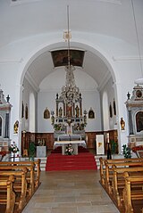
Interior of the church

Pulpit and stained glass window


Personalities
- Marc Machon (* 1995), ice hockey player
Web links
- Official website of the municipality of Vuisternens-en-Ogoz (French)
- Marianne Rolle: Vuisternens-en-Ogoz. In: Historical Lexicon of Switzerland .
- Aerial views of the village
Arconciel | Autigny | Avry | Belfaux | Chénens | Corminboeuf | Cottens | Ependes | Ferpicloz | Freiburg | Gibloux | Givisiez | Granges-Paccot | Grolley | Hauterive | La Brillaz | La Sonnaz | Le Mouret | Marly | Matran | Neyruz | Pierrafortscha | Ponthaux | Prez | Senèdes | Treyvaux | Villarsel-sur-Marly | Villars-sur-Glâne
Former parishes: Autafond | Avry-sur-Matran | Bonnefontaine | Chésalles | Chésopelloz | Cormagens | Corpataux | Corpataux-Magnedens | Corsalettes | Corserey | Corjolens | Cutterwil | Ecuvillens | Essert | Estavayer-le-Gibloux | Farvagny | Farvagny-le-Grand | Farvagny-le-Petit | Formangueires | Grenilles | Illens | La Corbaz | Le Glèbe | Lentigny | Lossy | Lossy Formangueires | Lovens | Magnedens | Marly-le-Grand | Marly-le-Petit | Montécu | Montévraz | Nierlet-les-Bois | Noréaz | Oberried | Onnens | Posat | Posieux | Prelude | Prez-vers-Noréaz | Rossens | Rueyres-Saint-Laurent | Sales | Villarlod | Villarsel-le-Gibloux | Vuisternens-en-Ogoz | Zénauva
Canton of Friborg | Districts of the canton of Friborg | Municipalities of the canton of Friborg