
Grolley
| Grolley | |
|---|---|
 |
|
| State : |
|
| Canton : |
|
| District : | Saane |
| BFS no. : | 2200 |
| Postal code : | 1772 |
| Coordinates : | 571982 / 187 007 |
| Height : | 625 m above sea level M. |
| Height range : | 521–734 m above sea level M. |
| Area : | 5.34 km² |
| Residents: | 1921 (December 31, 2018) |
| Population density : | 360 inhabitants per km² |
| Website: | www.grolley.ch |
_091.JPG) Grolley village center with church |
|
| Location of the municipality | |
  |
|
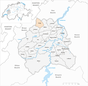
Grolley is a municipality in the District de la Sarine (German: Saanebezirk) in the canton of Friborg in Switzerland . On January 1, 2000, the formerly independent parish of Corsalettes was incorporated into Grolley.
geography
Grolley is 625 m above sea level. M. , 8 km west-northwest of the canton capital Friborg (linear distance). The village extends on a small hill of the Molasse plateau of the Freiburg Central Plateau , east of the valley of the village stream flowing to the Chandon . Grolley belongs to the Freiburg agglomeration .
The area of the 5.3 km² municipal area comprises a section of the slightly undulating Molasse plateau between the Broye plain in the north-west and the Saane in the south-east. The main part of the area is occupied by the Grolley Plateau, which is at an average altitude of 610 m above sea level. M. lies. The plateau, which has only slight differences in relief, is drained north by the village stream of Grolley ( La Morte ). North of the village, the brook has gradually created an erosion valley over time , which is mostly forested and sunk up to 50 m into the plateau. The western boundary of the municipality runs above the steep slope that slopes down to the Chandon valley. To the south, the municipality extends into the Forêt de l'Etat and reaches here at 730 m above sea level. M. the highest point of Grolley. To the east, the border lies on the road from Freiburg to Avenches, and the area extends to the edge of the forest of the Bois du Fossé . In 1997, 16% of the municipal area was accounted for by settlements, 18% for forests and woodlands and 66% for agriculture.
The village of Corsalettes ( 581 m above sea level ) on the northern slope of the Nomont, the hamlet of Guéravet ( 616 m above sea level ) on the high plateau east of the Chandon valley and some individual farms belong to Grolley. The neighboring municipalities of Grolley are Misery-Courtion , Belfaux , Ponthaux and Belmont-Broye .
population
With 1921 inhabitants (as of December 31, 2018), Grolley is one of the medium-sized communities in the canton of Friborg. 90.0% of the residents are French-speaking, 6.2% German-speaking and 1.2% speak Italian (as of 2000). The population of Grolley was 431 inhabitants in 1850, 461 inhabitants in 1900. During the 20th century, the population fluctuated between 490 and 570 inhabitants. Since 1970 (579 inhabitants) there has been a marked increase in population combined with almost tripling the number of inhabitants within 30 years.
economy
Up until the second half of the 20th century, Grolley was a predominantly agricultural village. Today arable farming , fruit growing , dairy farming and cattle breeding only play a minor role in the income structure of the population.
Numerous other jobs are available in local small businesses and in the service sector. An industrial and commercial zone has developed in Grolley since the 1970s. Today, companies from the construction industry, body construction, electrical engineering and precision engineering workshops are represented in the community. The Swiss Army has maintained a fleet of vehicles here with troop accommodation since 1970. There is also an oil tank farm south of the railway line. In the last few decades the village has also developed into a residential community. Many workers are therefore commuters who mainly work in the Freiburg region.
traffic
The community has good transport links. It is located on the main road from Freiburg to Payerne . The closest connection to the A12 motorway (Bern – Vevey) is around 6 km from the town center. On August 25, 1876, the railway line from Freiburg to Payerne with a train station in Grolley was put into operation.
history

The first written mention of the place took place in 1137 under the name Groslerio . Later the names Groslers (1138), Grolerio (1148) and Groslero (1175) appeared. The etymology of the place name is not clear. Grolley could have been derived from the patois expression grolle (jackdaw).
In the Middle Ages , Grolley formed its own little lordship among the nobles of Grolley. The village came under the rule of Freiburg through purchase in 1442 and was assigned to the old landscape (Spitalpanner). After the collapse of the Ancien Régime (1798), Grolley belonged to the Friborg district during the Helvetic and the following period before it was incorporated into the Saane district with the new cantonal constitution in 1848.
After the opening of the railway line from Freiburg to Payerne, a settlement gradually developed around the train station west of the village. In the course of the 20th century, the focus of the settlement shifted from Grolley more and more to the station area, while only a few new houses were built around the old village center. The village experienced an economic boom in the 1970s after the establishment of the army fleet and the barracks.
With effect from January 1, 2000, the previously independent Corsalettes was incorporated into Grolley. Through the merger, Grolley received a new coat of arms.
Attractions
There is evidence of a chapel in Grolley since 1354, which was rebuilt after a fire in 1760 and elevated to a parish church in 1802. The church of Saint-Jean-Baptiste was given its present form when it was rebuilt in 1910. In the village there is a stately patrician house from 1749, also known as the Château du village. A little east of Grolley is Rosières Castle, which dates back to a building originally from the 12th century, which was surrounded by a moat. The current Rosières Castle was built on the site of the old castle in the early 19th century.
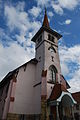
Grolley Church

Interior of the church

Patrician house Château du village (village castle)
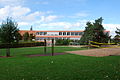
school

Bahnhofviertel
_077.JPG)
_079.JPG)
_101.JPG)
_095.JPG)
_103.JPG)
Web links
- Official website of the municipality of Grolley (French)
- Marianne Rolle / AW: Grolley. In: Historical Lexicon of Switzerland .
- Aerial views of the village
Individual evidence
- ↑ Permanent and non-permanent resident population by year, canton, district, municipality, population type and gender (permanent resident population). In: bfs. admin.ch . Federal Statistical Office (FSO), August 31, 2019, accessed on December 22, 2019 .
Arconciel | Autigny | Avry | Belfaux | Chénens | Corminboeuf | Cottens | Ependes | Ferpicloz | Freiburg | Gibloux | Givisiez | Granges-Paccot | Grolley | Hauterive | La Brillaz | La Sonnaz | Le Mouret | Marly | Matran | Neyruz | Pierrafortscha | Ponthaux | Prez | Senèdes | Treyvaux | Villarsel-sur-Marly | Villars-sur-Glâne
Former parishes: Autafond | Avry-sur-Matran | Bonnefontaine | Chésalles | Chésopelloz | Cormagens | Corpataux | Corpataux-Magnedens | Corsalettes | Corserey | Corjolens | Cutterwil | Ecuvillens | Essert | Estavayer-le-Gibloux | Farvagny | Farvagny-le-Grand | Farvagny-le-Petit | Formangueires | Grenilles | Illens | La Corbaz | Le Glèbe | Lentigny | Lossy | Lossy Formangueires | Lovens | Magnedens | Marly-le-Grand | Marly-le-Petit | Montécu | Montévraz | Nierlet-les-Bois | Noréaz | Oberried | Onnens | Posat | Posieux | Prelude | Prez-vers-Noréaz | Rossens | Rueyres-Saint-Laurent | Sales | Villarlod | Villarsel-le-Gibloux | Vuisternens-en-Ogoz | Zénauva
Canton of Friborg | Districts of the canton of Friborg | Municipalities of the canton of Friborg