
Ferpicloz
| Ferpicloz | |
|---|---|
 |
|
| State : |
|
| Canton : |
|
| District : | Saane |
| BFS no. : | 2194 |
| Postal code : | 1724 |
| Coordinates : | 579 196 / 177404 |
| Height : | 767 m above sea level M. |
| Height range : | 735–844 m above sea level M. |
| Area : | 1.02 km² |
| Residents: | 273 (December 31, 2018) |
| Population density : | 268 inhabitants per km² |
| Website: | www.ferpicloz.ch |
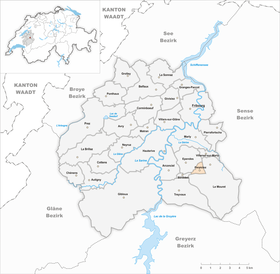
| Location of the municipality | |
  |
|
Ferpicloz ( Freiburger Patois ) is a municipality in the District de la Sarine (German: Saanebezirk) in the canton of Friborg in Switzerland . The former German place name Pichlen is no longer in use today.
geography
Ferpicloz is 767 m above sea level. M. , 7 km south of the canton capital Friborg (beeline). The village extends from a panoramic location on a high plateau east of the Bois d'Amont , in the pre-alpine hilly area of the Freiburg Central Plateau .
The area of the municipality area of just 1.0 km² covers a section of the higher Freiburg Central Plateau near the northern edge of the Alps. The central part is occupied by the height of Ferpicloz, which gradually slopes towards the southeast towards the valley of the Pontet . In the west, the municipality extends to the forest hill Bois d'Amont and reaches here at 842 m above sea level. M. the highest point of Ferpicloz. In 1997, 18% of the municipal area was accounted for by settlements, 12% for forests and woodlands and 70% for agriculture.
Ferpicloz includes that part of the Le Mouret ( 754 m above sea level ) and Rionbotset ( 764 m above sea level ) settlements west of the Freiburg - La Roche road , as well as several individual farms. Neighboring municipalities of Ferpicloz are Le Mouret , Senèdes and Ependes .
population
With 273 inhabitants (as of December 31, 2018) Ferpicloz is one of the small communities in the canton of Friborg. 85.8% of the residents are French-speaking, 12.0% German-speaking and 0.6% speak Russian (as of 2000). The population of Ferpicloz was 118 in 1850 and 132 in 1900. In the course of the 20th century the population fluctuated in the range between 130 and 150 people. Only since 1990 (138 inhabitants) has there been significant population growth.
economy
Ferpicloz was a predominantly agricultural village until the second half of the 20th century . Today arable farming , dairy farming and cattle breeding only play a minor role in the income structure of the population. Other jobs are available in local small businesses and in the service sector, including in a wood processing company. From 1630 to 1971 there was a brick factory in Le Mouret in the Ferpicloz area , which contributed significantly to the town's economic development. In the moorland south of the village, peat was extracted , especially during the Second World War . In the last few decades the village has developed into a residential community. Many workers are therefore commuters who mainly work in the Freiburg region.
traffic
The community is very well developed in terms of transport. It is only a little off the main road from Freiburg to Broc . Ferpicloz is connected to the public transport network by the Transports publics Fribourgeois bus routes , which run from Freiburg via La Roche to Bulle or Jaun .
history
The municipal area of Ferpicloz was settled early on. For example, the remains of a Roman manor were found near Le Mouret , which was inhabited from the middle of the 1st to the 4th century.
The first written mention of the place took place in the 12th century under the name Frigidum pesclum . Later the names Ferpehlou (1269), Ferpecles (1270) and Ferpecloz (1300) appeared. The place name probably goes back to the Latin words frigidum pasculum (cool willow).
Since 1270 Ferpicloz belonged to the Marly rule . In the 15th century the village came under the rule of Freiburg and was assigned to the old landscape (Burgpanner). After the collapse of the Ancien Régime (1798), Ferpicloz belonged to the La Roche district during the Helvetic period and to the Friborg district from 1803 before it was incorporated into the Saane district with the new cantonal constitution in 1848. Ferpicloz initially took part in the preparations for the Le Mouret merger project, but then left and is still an independent community today. Ferpicloz does not have its own church; it belongs to the parish of Ependes.
Web links
- Marianne Rolle / PO: Ferpicloz. In: Historical Lexicon of Switzerland .
- Aerial views of the village
Individual evidence
- ↑ Permanent and non-permanent resident population by year, canton, district, municipality, population type and gender (permanent resident population). In: bfs. admin.ch . Federal Statistical Office (FSO), August 31, 2019, accessed on December 22, 2019 .
Arconciel | Autigny | Avry | Belfaux | Chénens | Corminboeuf | Cottens | Ependes | Ferpicloz | Freiburg | Gibloux | Givisiez | Granges-Paccot | Grolley | Hauterive | La Brillaz | La Sonnaz | Le Mouret | Marly | Matran | Neyruz | Pierrafortscha | Ponthaux | Prez | Senèdes | Treyvaux | Villarsel-sur-Marly | Villars-sur-Glâne
Former parishes: Autafond | Avry-sur-Matran | Bonnefontaine | Chésalles | Chésopelloz | Cormagens | Corpataux | Corpataux-Magnedens | Corsalettes | Corserey | Corjolens | Cutterwil | Ecuvillens | Essert | Estavayer-le-Gibloux | Farvagny | Farvagny-le-Grand | Farvagny-le-Petit | Formangueires | Grenilles | Illens | La Corbaz | Le Glèbe | Lentigny | Lossy | Lossy Formangueires | Lovens | Magnedens | Marly-le-Grand | Marly-le-Petit | Montécu | Montévraz | Nierlet-les-Bois | Noréaz | Oberried | Onnens | Posat | Posieux | Prelude | Prez-vers-Noréaz | Rossens | Rueyres-Saint-Laurent | Sales | Villarlod | Villarsel-le-Gibloux | Vuisternens-en-Ogoz | Zénauva
Canton of Friborg | Districts of the canton of Friborg | Municipalities of the canton of Friborg