
Siviriez
| Siviriez | |
|---|---|
 |
|
| State : |
|
| Canton : |
|
| District : | Glane |
| BFS no. : | 2099 |
| Postal code : | 1678 |
| UN / LOCODE : | CH FSZ |
| Coordinates : | 556 944 / 167610 |
| Height : | 777 m above sea level M. |
| Height range : | 696–909 m above sea level M. |
| Area : | 20.28 km² |
| Residents: | 2239 (December 31, 2018) |
| Population density : | 110 inhabitants per km² |
| Website: | www.siviriez.ch |
 Siviriez |
|
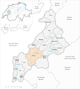
| Location of the municipality | |
  |
|
Siviriez ( Freiburger Patois ) is a municipality in the Glane district in the canton of Friborg in Switzerland . With effect from January 1, 2004, the previously independent municipalities of Chavannes-les-Forts , Prez-vers-Siviriez and Villaraboud were merged with the municipality of Siviriez.
geography
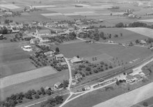
Siviriez lies at 777 m above sea level. M. , 5.5 km southwest of the district capital Romont (air line). The farming village is slightly elevated on a molasse plateau in the valley of the Ruisseau de Jogne , west of the upper reaches of the Glâne , in the southwestern Freiburg Central Plateau .
The area of the 20.3 km² municipality covers a section of the Molasse plateau of the Freiburg Central Plateau. The area is traversed from southwest to northeast by the Glâne, which forms a 0.3 to 1 km wide flat valley floor. This valley is flanked in the west by the heights of Sur la Gotte ( 865 m above sea level ) and La Moille ( 834 m above sea level ). To the north-west, the community soil extends over the valley of the Ruisseau de Jogne to the wide high plateau (around 800 m above sea level ), which borders the middle course of the Broye to the east. The culmination points are the heights of Le Saulgy ( 861 m above sea level ) and the forest hill Les Dailles ( 832 m above sea level ).
To the east, the upper Glâne valley is bounded by the Bois de Ban (at 909 m above sea level, the highest point in Siviriez) and the Fin d'Amont ( 852 m above sea level ). The municipality also includes the valley of the Ruisseau de Chavannes east of these heights and the lower section of the Fochaux stream . To the east, the community area extends over the gently sloping slope from Villaraboud to the moorland L'Ochère . In the very south, the area extends near the source of the Glâne. In 1997, 8% of the municipal area was in settlements, 17% in forests and woodlands, 74% in agriculture and a little less than 1% was unproductive land.
The villages of Prez-vers-Siviriez ( 765 m above sea level ), Chavannes-les-Forts ( 784 m above sea level ), Villaraboud ( 750 m above sea level ), Villaranon ( 791 m above sea level ) belong to Siviriez . ) and Le Saulgy ( 841 m above sea level ), also the hamlets of La Foule ( 721 m above sea level ), La Pierraz ( 718 m above sea level ), Les Buissons ( 718 m above sea level ) and Bramafan ( 700 m above sea level ), all in the Glâne valley, as well as some farm settlements and individual farms. Neighboring communities of Siviriez are Billens-Hennens , Romont , Mézières , Vuisternens-devant-Romont , Le Flon and Ursy in the canton of Friborg and Lucens in the canton of Vaud .
population
With 2239 inhabitants (as of December 31, 2018) Siviriez is one of the medium-sized communities in the canton of Friborg. 94.6% of the residents speak French, 2.0% speak Portuguese and 1.9% speak German (as of 2000). The population of Siviriez was 1823 in 1900 (including the villages that are incorporated today). After a peak around 1950 (1988 inhabitants) a strong emigration began, so that Siviriez only had 1,458 inhabitants in 1970. Only since around 1980 has there been significant population growth again.
economy
Until the second half of the 20th century, Siviriez was predominantly an agricultural community. Today who have dairy industry , the livestock and agriculture an important role in the employment structure of the population. Further jobs are available in local small businesses and in the service sector. Companies in the construction industry, kitchen construction, mechanical workshops as well as joineries and carpenters are represented in the municipality. In the extreme northeast of the municipality, above Drognens, are the barracks of the Romont arsenal. In the last few decades the village has also developed into a residential community thanks to its attractive location. Many workers are therefore commuters who work mainly in the Romont and Freiburg regions.
traffic
Siviriez is very well developed in terms of traffic. It is on the main road from Romont via Ursy to Moudon . On September 4, 1862, the railway line from Lausanne to Freiburg with a train station in Siviriez was put into operation. Siviriez is also connected to the public transport network by the bus lines of the Freiburg Transport Authority , which run from Romont via Ursy and Oron-la-Ville to Palézieux-Gare and Romont via Ursy and Vauderens to Moudon.
history
The first written mention of the place comes from the 12th century under the names Seurei , Seuirei and Severiacus . Later the names Sivrie (1228), Sivirie (1247), Syvrie (1285), Siurier (1403), Sivirier (1578) and Cheverié (1755) appeared. The place name is derived from the Latin personal name Sever (i) us .
Siviriez had been under Savoy rule since the middle of the 13th century. Siviriez was oriented towards the Romont dominion, while the current southern parts of the municipality with Prez-vers-Siviriez and Le Saulgy belonged to the Savoy Kastlanei Rue (this division of the municipality remained until 1848). When the Bernese conquered Vaud in 1536, Siviriez came under the rule of Friborg and was assigned to the Bailiwick of Romont. After the collapse of the Ancien Régime (1798), the village belonged to the Romont district during the Helvetic and the following period and was incorporated into the Glâne district in 1848.
A first enlargement of the municipality of Siviriez took place on January 1, 1978, when the previously independent municipalities Le Saulgy and Villaranon were incorporated. That was when the coat of arms was changed for the first time. As part of the municipal mergers promoted by the canton of Friborg since 2000, the villages of Prez-vers-Siviriez , Chavannes-les-Forts and Villaraboud were also merged with Siviriez with effect from January 1, 2004 . As a result of this merger, the entire community received a new coat of arms.

Siviriez coat of arms until 1978

Siviriez coat of arms 1978
to 2004


Personalities
- Marguerite Bays (1815–1879), canonized
Web links
- Official website of the municipality of Siviriez
- Marianne Rolle: Siviriez. In: Historical Lexicon of Switzerland .
- Evelyne Maradan: Chavannes-les-Forts. In: Historical Lexicon of Switzerland .
- Aerial views of Siviriez
Individual evidence
- ↑ Permanent and non-permanent resident population by year, canton, district, municipality, population type and gender (permanent resident population). In: bfs. admin.ch . Federal Statistical Office (FSO), August 31, 2019, accessed on December 22, 2019 .
Auboranges | Billens-Hennens | Chapelle (Glâne) | Châtonnaye | Ecublens | Grangettes | Le Châtelard | Massonnens | Mezieres | Montet (Glâne) | Romont | Rue | Siviriez | Torny | Ursy | Villaz | Villorsonnens | Vuisternens-devant-Romont
Former parishes: Arrufens | Berlens | Bionnens | Billens | Blessens | Chavannes-les-Forts | Chavannes-sous-Orsonnens | Eschiens | Esmonts | Estévenens | Fuyens | Gillarens | Grange-la-Battiaz | Hennens | La Folliaz | La Joux | La Magne | La Neirigue | Le Saulgy | Les Ecasseys | Les Glânes | Lussy | Lieffrens | Macconnens | Middes | Morlens | Mossel | Orsonnens | Prez-vers-Siviriez | Promasens | Sommentier | Torny-le-Grand | Vauderens | Villangeaux | Villaraboud | Villaranon | Villargiroud | Villariaz | Villarimboud | Villarsiviriaux | Villaz-Saint-Pierre | Vuarmarens
Canton of Friborg | Districts of the canton of Friborg | Municipalities of the canton of Friborg