
Chavannes-sur-Moudon
| Chavannes-sur-Moudon | |
|---|---|
 |
|
| State : |
|
| Canton : |
|
| District : | Broye-Vully |
| BFS no. : | 5665 |
| Postal code : | 1512 |
| Coordinates : | 551 776 / 167496 |
| Height : | 680 m above sea level M. |
| Height range : | 539–848 m above sea level M. |
| Area : | 5.15 km² |
| Residents: | 215 (December 31, 2018) |
| Population density : | 42 inhabitants per km² |
| Website: | www.chavannes-sur-moudon.ch |
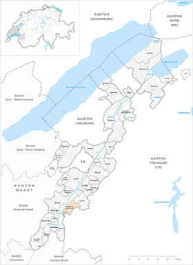
 Chavannes-sur-Moudon |
|
| Location of the municipality | |
  |
|
Chavannes-sur-Moudon is a municipality in the Broye-Vully district in the canton of Vaud in Switzerland .
geography

Chavannes-sur-Moudon is 680 m above sea level. M. , 20.5 km southwest of the district capital Payerne (linear distance). The small clustered village extends on a saddle east of the middle Broyetal , in the eastern Vaud Central Plateau .
The area of the 5.2 km² municipal area comprises a section of the Molasse hill country between the Broyetal and the upper reaches of the Glâne . The north-western border of the municipality is formed by the densely wooded escarpment of the Broyetal; in the southwest the area extends almost down to the Broye. From the hill Le Dévin ( 724 m above sea level ) on the edge of the Broye valley, the municipality extends eastward to the forest height En Ardra (up to 760 m above sea level ) and in a narrow strip to the height of Brûle Fer , on the 848 m above sea level M. the highest point of Chavannes-sur-Moudon is reached. The north-eastern border runs in the erosion valley of the Voraire , a short right side brook of the Broye, cut deep into the slope . In 1997, 5% of the municipal area was accounted for by settlements, 20% for forests and woodlands and 75% for agriculture.
Several individual farms belong to Chavannes-sur-Moudon. Neighboring municipalities of Chavannes-sur-Moudon are Vulliens , Moudon and Lucens in the canton of Vaud and Montet (Glâne) and Ursy in the canton of Friborg .
population
With 215 inhabitants (as of December 31, 2018), Chavannes-sur-Moudon is one of the small communities in the canton of Vaud. 96.5% of the residents are French-speaking, 3.1% German-speaking and 0.5% speak Albanian (as of 2000). The population of Chavannes-sur-Moudon was 342 in 1850 and 335 in 1900. Thereafter, a decrease of almost 50% to 180 inhabitants was recorded by 1980; since then the population has increased slightly again.
economy
Chavannes-sur-Moudon still lives mainly from agriculture , especially from agriculture , fruit growing and cattle breeding . There are very few jobs outside the primary sector. In the last few decades the village has also developed into a residential community. Some workers are commuters who mainly work in Moudon.
traffic
The community is located away from the major thoroughfares. The main access is from Moudon , there are other small roads to Vuarmarens and Chesalles-sur-Moudon . The Postbus course, which runs from Moudon to Lucens , connects Chavannes-sur-Moudon to the public transport network.
history
The earliest evidence of the land grabbing by humans in the municipality is a barrow from the Hallstatt period . The first written mention of the place took place only in 1453 under the name Chavanes . The place name is derived from the vulgar Latin capanna (hut, small courtyard).
In the 15th century Chavannes-sur-Moudon belonged to the Kastlanei Rue. The village was successively owned by the lords of Moudon, Illens, Villardin and Prez. In 1663 it came to the de Loys family, who acquired the various feudal and lordship rights. With the conquest of Vaud by Bern in 1536, Chavannes-sur-Moudon came under the administration of the Moudon bailiffs . After the collapse of the Ancien Régime , the village belonged to the canton of Léman from 1798 to 1803 during the Helvetic Republic , which then became part of the canton of Vaud when the mediation constitution came into force . In 1798 it was assigned to the Moudon district.
Attractions
A chapel in Chavannes-sur-Moudon is mentioned as early as the Middle Ages . The current building was last extensively restored in 1942. Some characteristic farmhouses from the 18th and 19th centuries have been preserved in the town center.
literature
- Monique Fontannaz, Brigitte Pradervand: Le district de la Broye-Vully 1. (= The art monuments of Switzerland. Volume 128). Ed. Society for Swiss Art History SKG. Bern 2015, pp. 262–268, ISBN 978-3-03797-180-2 .
Web links
- Official website of the municipality of Chavannes-sur-Moudon
- Valérie Favez: Chavannes-sur-Moudon. In: Historical Lexicon of Switzerland .
- Aerial views of the village
Individual evidence
- ↑ Permanent and non-permanent resident population by year, canton, district, municipality, population type and gender (permanent resident population). In: bfs. admin.ch . Federal Statistical Office (FSO), August 31, 2019, accessed on December 22, 2019 .
Avenches | Bussy-sur-Moudon | Champtauroz | Chavannes-sur-Moudon | Chevroux | Corcelles-le-Jorat | Corcelles-près-Payerne | Cudrefin | Curtilles | Dompierre | Faoug | Grandcour | Henniez | Hermenches | Lovatens | Lucens | Missy | Moudon | Payerne | Prévonloup | Ropraz | Rossenges | Syens | Trey | Treytorrens (Payerne) | Valbroye | Villars-le-Comte | Villarzel | Vucherens | Vulliens | Vully-les-Lacs
Former parishes: Bellerive | Brenles | Carrouge | Cerniaz | Chabrey | Champmartin | Chesalles-sur-Moudon | Combremont-le-Grand | Combremont-le-Petit | Constantine | Cremin | Forel-sur-Lucens | Donatyre | Granges-près-Marnand | Marnand | Montmagny | Mur | Oleyres | Oulens-sur-Lucens | Rossens | Sarzens | Sassel | Sédeilles | Seigneux | Vallamand | Villars-Bramard | Villars-le-Grand
Canton of Vaud | Districts of the canton of Vaud | Municipalities of the canton of Vaud