
Cudrefin
| Cudrefin | |
|---|---|
.svg) |
|
| State : |
|
| Canton : |
|
| District : | Broye-Vully |
| BFS no. : | 5456 |
| Postal code : | 1588 |
| Coordinates : | 568 007 / 200614 |
| Height : | 434 m above sea level M. |
| Height range : | 429-579 m above sea level M. |
| Area : | 15.51 km² |
| Residents: | 1633 (December 31, 2018) |
| Population density : | 105 inhabitants per km² |
| Website: | www.cudrefin.ch |
 Cudrefin |
|
| Location of the municipality | |
  |
|
Cudrefin [ kydʀəˈfɛ̃ ] is a municipality in the Broye-Vully district in the canton of Vaud in Switzerland . The former German place name Guderfi is no longer used today.
geography
Cudrefin is 434 m above sea level. M. , 16 km northeast of the district capital Payerne (linear distance). The village extends in the plain north of the ridge of Mont Vully , near the south-eastern shore of Lake Neuchâtel , opposite the city of Neuchâtel , in the Swiss plateau . Cudrefin is the northernmost municipality in the canton.
The area of the 15.8 km² large municipal area includes a section on the south-eastern shore of Lake Neuchâtel. The parish extends southward from the lakeshore over a reed and forest belt into the Marais de Cudrefin plain, which is up to 2 km wide . The north-eastern border runs along the lowest section of the Canal de la Broye ( Broye Canal between Lake Murten and Lake Neuchâtel). To the south of the plain is the broad ridge southwest of Mont Vully, which is subdivided by several valleys and ridges. The highest point of Cudrefin is 578 m above sea level. M. at the edge of the forest Bois de l'Allou . In the extreme southwest is the Bois de Ville forest area . Here, between the ridge and Lake Neuchâtel, an up to 70 m high, partly rocky, steep slope has formed. In 1997, 7% of the municipal area was settled, 24% forest and woodland, 61% agriculture and a little more than 8% was unproductive land (marshland and reed belt along Lake Neuchâtel). The reed belt is now a nature reserve and bird sanctuary.
The village of Champmartin , which was independent until 2001 , the hamlet of Montet ( 480 m above sea level ) on the north slope of the ridge, Vers chez Jacot ( 435 m above sea level ) and Le Moulin ( 444 m above sea level ) on the village stream belong to Cudrefin von Cudrefin, the farm settlements of La Sauge ( 436 m above sea level ) on the left bank of the Broye Canal and Pégran ( 450 m above sea level ) at the foot of Mont Vully as well as some individual farms. Neighboring municipalities of Cudrefin are Vully-les-Lacs in the canton of Vaud, Mont-Vully in the canton of Friborg and Ins in the canton of Bern .
population
With 1633 inhabitants (as of December 31, 2018), Cudrefin is one of the smaller municipalities in the canton of Vaud. 74.7% of the residents are French-speaking, 21.1% German-speaking and 1.6% Portuguese-speaking (as of 2000). The population of Cudrefin was 740 in 1850 and 699 in 1900 (including Champmartin). After the population had decreased to 571 people by 1970, a significant increase in population has been registered since then.
economy

Until the middle of the 20th century, Cudrefin was a predominantly agricultural village. Thanks to the fertile soils, agriculture and fruit growing still play an important role in the income structure of the population. Further jobs are available in local small businesses and especially in the service sector. In addition to small businesses, Cudrefin also has companies in the construction industry, computer technology and the construction of agricultural machinery. In the last few decades the village has also developed into a residential community. Many employed people are commuters, some of whom work in Neuchâtel.
tourism
Cudrefin is a resort and holiday resort on the shores of Lake Neuchâtel. It has a good tourist infrastructure with holiday homes, a campsite, a beach and two large sailing ports.
traffic
The community is very well developed in terms of traffic. It is located on the connecting road from Avenches to Gampelen and the A5 motorway (Biel-Neuchâtel). The village is connected to the public transport network by the Postbus course that runs from Avenches to Cudrefin. There are also several Postbus connections to Ins train station every day . Through the shipping network on Lake Neuchâtel, Cudrefin has some connections with the city of Neuchâtel in summer.
history


The municipality of Cudrefin was populated very early. Several settlements that have been inhabited since the Neolithic were examined along Lake Neuchâtel . Rich archaeological finds have been made.
The place was first mentioned in a document in 999 under the name Curlefin . Numerous other names appeared in the later years: Codrufim (1184), Culdrefin (1163), Cordefin (1214), Cordelfin (1215), Cudulfin (1228), Cudrufin (1229), Cordulfin (1240), for the first time Cudrefin (1243), then Codefrin (1246), Codulfrin (1268), Culderphin (1269), Culdurphi (1270), Cudrufin (1285), Caudrefin and Cudrifin (around 1300), Cudriffin (1477) and in 1668 again Cudrefin. The place name is made up of the late Latin word cortis (court) and the Germanic personal name Wulfin .
Since it was first mentioned, Cudrefin was owned by the Bishop of Sion. He sold his property to Peter of Savoy in 1246 . Under Savoyard rule, the place was expanded into a fortified country town and the center of a Kastlanei. The town is first mentioned in the documents in 1268; the date of the first granting of town charter is unknown, but in 1471 the town privileges were renewed. Shortly after 1300 Cudrefin came under the rule of the von Grandson family, and in 1393 again under the direct administration of Savoy.
During the Burgundian Wars (1475) the town was temporarily taken by the Freiburgers. With the conquest of Vaud by Bern in 1536, Cudrefin came under the administration of the Bailiwick of Avenches . In 1790 numerous houses fell victim to a conflagration. After the collapse of the Ancien Régime , the place was annexed to the canton of Friborg during the Helvetic period in 1798 . When the mediation constitution came into force in 1803, Cudrefin was reassigned to the canton of Vaud as an exclave together with what is now the Avenches district.
At the beginning of the 19th century the city gates and other fortifications were demolished. With the first correction of the waters of the Jura , which was completed in 1891, a strip of new land was created on the shores of Lake Neuchâtel through the lowering of the water, and a bird sanctuary was established in 1948. The wide belt of reeds along the lake, which increased after the second correction of the Jura waters, has been owned by the canton since 1965. Since January 1, 2002, the hamlet of Champmartin , which previously formed an independent political municipality, belongs to Cudrefin.
Attractions
After the town was fortified in the 13th century, Cudrefin had a curtain wall with two city gates. This was completely removed in the 19th century. The only remnant of the former fortification is a tower that was transformed into the church tower of the neighboring church. Stately town houses and farmhouses from the 17th to 19th centuries have been preserved on both sides of the main street. The Hôtel de Ville (town hall) is a new building from 1839. The Fontaine de la Justice (Fountain of Justice), built in 1605, is located in the main square.
On a hill near Montet is the reformed parish church of Saint-Théodule, a late Gothic building built in the 15th century . Next to it is the rectory, which was also built in the 15th century but was later redesigned in Baroque style .

The church of Montet-Cudrefin
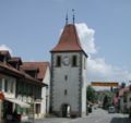
Clock tower


Web links
- Official website of the municipality of Cudrefin (French)
- Brigitte Pradervand: Cudrefin. In: Historical Lexicon of Switzerland .
- Gilbert Marion: Champmartin. In: Historical Lexicon of Switzerland .
- Aerial views of the village
- Château de Cudrefin
Individual evidence
- ↑ Permanent and non-permanent resident population by year, canton, district, municipality, population type and gender (permanent resident population). In: bfs. admin.ch . Federal Statistical Office (FSO), August 31, 2019, accessed on December 22, 2019 .
Avenches | Bussy-sur-Moudon | Champtauroz | Chavannes-sur-Moudon | Chevroux | Corcelles-le-Jorat | Corcelles-près-Payerne | Cudrefin | Curtilles | Dompierre | Faoug | Grandcour | Henniez | Hermenches | Lovatens | Lucens | Missy | Moudon | Payerne | Prévonloup | Ropraz | Rossenges | Syens | Trey | Treytorrens (Payerne) | Valbroye | Villars-le-Comte | Villarzel | Vucherens | Vulliens | Vully-les-Lacs
Former parishes: Bellerive | Brenles | Carrouge | Cerniaz | Chabrey | Champmartin | Chesalles-sur-Moudon | Combremont-le-Grand | Combremont-le-Petit | Constantine | Cremin | Forel-sur-Lucens | Donatyre | Granges-près-Marnand | Marnand | Montmagny | Mur | Oleyres | Oulens-sur-Lucens | Rossens | Sarzens | Sassel | Sédeilles | Seigneux | Vallamand | Villars-Bramard | Villars-le-Grand
Canton of Vaud | Districts of the canton of Vaud | Municipalities of the canton of Vaud