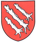
Cerniaz
| Cerniaz | ||
|---|---|---|
| State : |
|
|
| Canton : |
|
|
| District : | Broye-Vully | |
| Municipality : | Valbroye | |
| Postal code : | 1682 | |
| former BFS no. : | 5811 | |
| Coordinates : | 558550 / 175.35 thousand | |
| Height : | 687 m above sea level M. | |
| Area : | 1.77 km² | |
| Residents: | 55 (December 31, 2010) | |
| Population density : | 31 inhabitants per km² | |
| map | ||
|
|
||
Cerniaz (VD) ([ sɛʀnja ], in the local dialect: [ θɛrˈnja ]) was a political municipality in the Granges-près-Marnand district of the Broye-Vully district in the Swiss canton of Vaud until it merged with some neighboring communities to Valbroye on July 1, 2011 .
The canton abbreviation VD is used by the Swiss federal authorities to distinguish Cerniaz from the homophonic Freiburg village and former municipality of Cerniat .
geography
Cerniaz lies at 687 m above sea level. M. , eleven kilometers south-southwest of the district capital Payerne (linear distance ). The street village extends over a terrace on the upper eastern slope of the Broye , in the eastern Vaudois Plateau .
The area of the 1.8 km² former municipal area covers a section of the hill country between the Broyetal and the Glânetal . The whole area is on a slope that drops to the northwest to the Broye. This slope is divided in two by the Trémeule valley, cut deep into the molasse layers . At the height of La Careime is 751 m above sea level. M. reached the highest point of Cerniaz. In 1997, 4% of the municipal area was accounted for by settlements, 19% for forests and woodlands and 77% for agriculture.
The hamlet of La Ville ( 700 m above sea level ) above the village and a few individual farms belonged to the municipality of Cerniaz . Neighboring communities of Cerniaz were Villarzel , Villars-Bramard , Seigneux and Henniez .
population
With 55 inhabitants (as of December 31, 2010), Cerniaz was one of the smallest municipalities in the canton of Vaud. 98.4% of the residents are French-speaking and 1.6% German-speaking (as of 2000). The population of Cerniaz was 173 in 1870, compared to 145 in 1900. After the population had decreased by a further 60% to 56 people by 1990, the number of inhabitants has remained practically stable since then.
economy
Cerniaz still lives mainly from agriculture , especially from agriculture and cattle breeding . Outside the primary sector there are no jobs in the village. Some workers are also commuters who work in the larger towns in the area.
traffic
Cerniaz is located off the major thoroughfares on a connecting road from Marnand to Romont . Cerniaz is connected to the public transport network by a post bus that runs from Payerne to Romont.
history
The municipality was settled as early as the Burgundian period, which is evidenced by finds of graves from this time. Remains of an early medieval fortification were also discovered. The first mention of the place is found in 1153 as Sernia in a register of the possessions of the Abbey of Hauterive . Cerniaz is a Franco-Provençal equivalent of the French word cernée , "area freed by clearing".
Since the Middle Ages, Cerniaz was under the jurisdiction of Villarzel , which in turn belonged to the Bishop of Lausanne . With the conquest of Vaud by Bern in 1536, the village came under the administration of the Bailiwick of Moudon . After the collapse of the Ancien Régime Cerniaz belonged from 1798 to 1803 during the Helvetic Republic to Canton Léman , the then with the enactment of the Mediation Constitution opened in canton Vaud. In 1798 it was assigned to the Payerne district. Cerniaz, part of the parish of Dompierre, had a chapel in the Middle Ages.
Attractions
literature
- Monique Fontannaz, Brigitte Pradervand: “Le district de la Broye-Vully 1.” (= The art monuments of Switzerland. Volume 128). Ed. Society for Swiss Art History SKG. Bern 2015, pp. 365–366, ISBN 978-3-03797-180-2 .
Web links
- Community information
- Valérie Favez: Cerniaz (VD). In: Historical Lexicon of Switzerland .
- Cerniaz village and surroundings (aerial photo / map)
Individual evidence
- ↑ a b Florence Cattin, Cerniaz VD (Payerne) in: Dictionnaire toponymique des communes suisses - Lexicon of Swiss community names - Dizionario toponomastico dei comuni svizzeri (DTS | LSG) , Center de dialectologie, Université de Neuchâtel, Verlag Huber, Frauenfeld / Stuttgart / Vienna 2005, ISBN 3-7193-1308-5 and Éditions Payot, Lausanne 2005, ISBN 2-601-03336-3 , p. 226.


