
Champtauroz
| Champtauroz | |
|---|---|
 |
|
| State : |
|
| Canton : |
|
| District : | Broye-Vully |
| BFS no. : | 5812 |
| Postal code : | 1537 |
| Coordinates : | 550 256 / 178 997 |
| Height : | 692 m above sea level M. |
| Height range : | 625–734 m above sea level M. |
| Area : | 3.05 km² |
| Residents: | 122 (December 31, 2018) |
| Population density : | 40 inhabitants per km² |
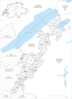
 Champtauroz |
|
| Location of the municipality | |
  |
|
Champtauroz is a municipality in the Broye-Vully district in the canton of Vaud in Switzerland .
geography
Champtauroz is 692 m above sea level. M. , 13 km southwest of the district capital Payerne (linear distance). The clustered village extends on a ledge on the western slope of the Petite Glâne , in the Molasse hill country of the northern Vaud Central Plateau .
The area of the 3.1 km² municipal area covers a section of the hill country between Lake Neuchâtel and the Broyetal . The eastern part of the municipality is occupied by the valley of the upper Petite Glâne. The Bois de la Chaux forest also belongs to Champtauroz. In the south is the 712 m high forest hill Gransou . To the west, the municipality extends over the height of Haut du Mont ( 728 m above sea level ) to the upper reaches of the Ruisseau des Vaux (tributary of the Mentue ). The highest point of Champtauroz is 731 m above sea level. M. on the Bois du Mont north of the village. In 1997, 6% of the municipal area was accounted for by settlements, 19% for forests and woodlands and 75% for agriculture.
The hamlet of Le Pontet ( 657 m above sea level ) in the Petite Glâne valley and some individual farms belong to Champtauroz . Neighboring municipalities of Champtauroz are Démoret , Chêne-Pâquier , Chavannes-le-Chêne , Treytorrens (Payerne) and Valbroye in the canton of Vaud and the exclave of Estavayer in the canton of Friborg .
population
With 122 inhabitants (as of December 31, 2018), Champtauroz is one of the smallest municipalities in the canton of Vaud. 95.0% of the residents are French-speaking, 3.0% German-speaking and 1.0% English-speaking (as of 2000). The population of Champtauroz was 216 in 1850, compared to 187 in 1900. After the population had decreased by a further 50% to 95 people by 1980, a slight increase in population has been observed since then.
economy
Champtauroz was a predominantly agricultural village until the second half of the 20th century . Even today, arable farming , fruit growing and cattle breeding play an important role in the income structure of the population. Further jobs are available in local small businesses and in the service sector. The village is the location of a cheese dairy.
traffic
The community is located off the major thoroughfares on a connecting road from Prahins to Murist . Champtauroz is connected to the public transport network by a bus that runs a circular route through the hinterland from Estavayer-le-Lac .
history
The first written mention of the place took place in 1228 under the name Chantuoro . Later the names Chanteurre (1437) and Chantouroz (1453) appeared. The origin of the place name is not known.
In the Middle Ages Champtauroz was part of the dominion of Saint-Martin-du-Chêne, in 1338 it came to the Lutry Priory . With the conquest of Vaud by Bern in 1536, the village came under the administration of the Bailiwick of Moudon . After the collapse of the Ancien Régime , Champtauroz belonged to the canton of Léman from 1798 to 1803 during the Helvetic Republic, which then became part of the canton of Vaud when the mediation constitution came into force . In 1798 it was first assigned to the Moudon district, in 1803 it came to the Payerne district.
Attractions
A church in Champtauroz has been attested since 1228. This was converted into a school in 1840, which has since been closed. As a replacement, a new church was built around 1900 at the south-western entrance to the village. A village oven from 1787 was restored in 1987. In Champtauroz some characteristic farmhouses from the 17th to 19th centuries have been preserved.
literature
- Monique Fontannaz, Brigitte Pradervand: Le district de la Broye-Vully 1. (= The art monuments of Switzerland. Volume 128). Ed. Society for Swiss Art History SKG. Bern 2015, pp. 350–352, ISBN 978-3-03797-180-2 .
Web links
- Community information
- Valérie Favez: Champtauroz. In: Historical Lexicon of Switzerland .
- Aerial view of the village
Individual evidence
- ↑ Permanent and non-permanent resident population by year, canton, district, municipality, population type and gender (permanent resident population). In: bfs. admin.ch . Federal Statistical Office (FSO), August 31, 2019, accessed on December 22, 2019 .
Avenches | Bussy-sur-Moudon | Champtauroz | Chavannes-sur-Moudon | Chevroux | Corcelles-le-Jorat | Corcelles-près-Payerne | Cudrefin | Curtilles | Dompierre | Faoug | Grandcour | Henniez | Hermenches | Lovatens | Lucens | Missy | Moudon | Payerne | Prévonloup | Ropraz | Rossenges | Syens | Trey | Treytorrens (Payerne) | Valbroye | Villars-le-Comte | Villarzel | Vucherens | Vulliens | Vully-les-Lacs
Former parishes: Bellerive | Brenles | Carrouge | Cerniaz | Chabrey | Champmartin | Chesalles-sur-Moudon | Combremont-le-Grand | Combremont-le-Petit | Constantine | Cremin | Forel-sur-Lucens | Donatyre | Granges-près-Marnand | Marnand | Montmagny | Mur | Oleyres | Oulens-sur-Lucens | Rossens | Sarzens | Sassel | Sédeilles | Seigneux | Vallamand | Villars-Bramard | Villars-le-Grand
Canton of Vaud | Districts of the canton of Vaud | Municipalities of the canton of Vaud