Granges-près-Marnand
| Granges-près-Marnand | ||
|---|---|---|
| State : |
|
|
| Canton : |
|
|
| District : | Broye-Vully | |
| Municipality : | Valbroye | |
| Postal code : | 1523 | |
| former BFS no. : | 5818 | |
| UN / LOCODE : | CH GPM | |
| Coordinates : | 557855 / 179246 | |
| Height : | 473 m above sea level M. | |
| Area : | 6.95 km² | |
| Residents: | 1218 (December 31, 2010) | |
| Population density : | 175 inhabitants per km² | |
| Website: | www.granges-md.ch | |
|
Granges-près-Marnand |
||
| map | ||
|
|
||
Until the merger to form Valbroye on July 1, 2011, Granges-près-Marnand was a municipality in the Broye-Vully district of the canton of Vaud in Switzerland . Until 1952 the municipality was called Granges (VD) .
geography
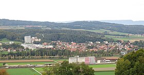
Granges-près-Marnand lies at 473 m above sea level. M. , eight kilometers southwest of the district capital Payerne (air line). The clustered village extends on the western edge of the Broyetal , on both sides of the Lembe stream , in the eastern Vaud Central Plateau .
The area of the 7.0 km² former municipal area comprises a section in the central Broyetal. The eastern part of the municipality was taken up by the flat valley plain, which is partly over a kilometer wide, with the border mostly running east of the canalized Broye along the railway line. To the west, the municipality extended into the valley of the lower Lembe, flanked by the height of Chassagne ( 564 m above sea level. M. ) in the north and the forest Les Râpes in the south, in which 620 m above sea level. M. the highest point of Granges-près-Marnand is reached. In the north the area extends to the high terrace of Brit and to the canalized Ruisseau du Moulin , the village stream of Ménières. In 1997, 12% of the municipal area was settled, 22% forest and woodland, 63% agriculture and a little less than 3% was unproductive land (two extensive sand and gravel pits).
The hamlet of Brit ( 477 m above sea level ), on a terrace west of the Broye, with the neighboring farm estate Maison Neuve ( 480 m above sea level ) and some individual farms belonged to the municipality of Granges-près-Marnand . Neighboring communities of Granges-près-Marnand were Trey , Marnand , Henniez and Sassel in the canton of Vaud and Ménières , Fétigny , Villeneuve , Surpierre and Cheiry in the canton of Friborg .
population
With 1218 inhabitants (as of December 31, 2010) Granges-près-Marnand was one of the medium-sized municipalities in the canton of Vaud. Of the residents, 85.2% are French-speaking, 3.8% Portuguese-speaking and 3.4% speak Albanian (as of 2000). The population of Granges-près-Marnand was 841 in 1870 and 942 in 1900. After a temporary slight population decline in the first half of the 20th century, the number of inhabitants has increased slowly but continuously since 1950 (856 inhabitants).
economy
Granges-près-Marnand is a small regional center on the middle reaches of the Broye between Payerne and Moudon. Until the beginning of the 20th century, the village was dominated by agriculture . Today arable farming (including tobacco cultivation), fruit growing and cattle breeding are only of secondary importance in the income structure of the population.
In the course of the 20th century, a number of handicraft and industrial companies as well as banks settled in Granges-près-Marnand. The most important company is Desmeules Frères SA (now owned by Vigier Holding SA), which emerged from a company founded in 1901 for the exploitation of sand pits and which today produces precast concrete parts. The factory has two large sand and gravel pits. Other companies have established themselves in the construction industry, animal breeding, food wholesaling and body construction.
Granges-près-Marnand also has a municipal library (since 1862), banks, a retirement and nursing home and several sports facilities, including a tennis center.
traffic
Granges-près-Marnand has good transport links. It is only 1 km away from the relatively busy main road 1 from Lausanne via Payerne to Bern , which was the main axis from Bern to western Switzerland before the motorway was built. On August 25, 1876, the Payerne-Moudon railway with the Granges-Marnand station on the municipal boundary of Granges-près-Marnand and Marnand was put into operation. A Postbus course, which runs from the train station to Cheiry , provides for the fine distribution in public transport .
On July 29, 2013, the Granges-Marnand railway accident occurred in the station , in which a train driver died and 45 passengers were injured.
history
The municipality of Granges-près-Marnand was populated very early. Traces from the Bronze Age , foundations of a Roman villa and early medieval graves have been found. The place was first mentioned in a document in 881 under the name in fine Graniacense , and in 1228 the name Granges appeared . The place name is derived from the late Latin word granea and originally referred to a granary , later also an entire farm.
Granges-près-Marnand has been under the authority of the Lausanne Cathedral Chapter and the Payerne Monastery since the 13th century. With the conquest of Vaud by Bern in 1536, the village came under the administration of Kastlanei Villarzel in the Bailiwick of Moudon . After the collapse of the Ancien Régime , Granges-près-Marnand belonged to the canton of Léman from 1798 to 1803 during the Helvetic Republic, which then became part of the canton of Vaud when the mediation constitution came into force . In 1798 it was assigned to the Payerne district. The hamlet of Brit, which used to be its own small estate, became part of Granges-près-Marnand in 1806. Before the Correction of the Broye, the village was hit by severe floods several times, notably in 1774, 1888 and 1895.
Attractions
At the southern end of the village is the Reformed parish church from the 12th to 14th centuries, which has Romanesque and Gothic elements. Inside there are remains of wall paintings from the 15th century. The church tower was rebuilt in 1808. Excavations have shown that the church stands on the site of a Roman villa, the foundation walls of which were used as early as the 7th century for the construction of a chapel and later for the construction of the first church. The rectory dates from 1591.
literature
- Monique Fontannaz, Brigitte Pradervand: “Le district de la Broye-Vully 1.” (= The art monuments of Switzerland. Volume 128). Ed. Society for Swiss Art History SKG. Bern 2015, pp. 384–402, ISBN 978-3-03797-180-2 .
Web links
- Official website of the municipality of Granges-près-Marnand (French)
- Valérie Favez: Granges-près-Marnand. In: Historical Lexicon of Switzerland .
- Aerial views of the village


