Surpierre
| Surpierre | |
|---|---|
| State : |
|
| Canton : |
|
| District : | Broye |
| BFS no. : | 2044 |
| Postal code : | 1527 Villeneuve 1528 Praratoud 1528 Surpierre |
| Coordinates : | 555 867 / 177 191 |
| Height : | 618 m above sea level M. |
| Height range : | 466–704 m above sea level M. |
| Area : | 8.35 km² |
| Residents: | 708 (December 31, 2018) |
| Population density : | 85 inhabitants per km² |
| Website: | www.surpierre-fr.ch |
| Location of the municipality | |
Surpierre ( Freiburger Patois ) is a municipality in the Broye district in the canton of Friborg in Switzerland . The former German name Überstein is no longer used today.
geography
Surpierre is 618 m above sea level. M. , 11 km southwest of Payerne (linear distance) in the Freiburg exclave Surpierre. The village extends on a terrace on both sides of the Dorfbach, which flows in a small valley, around 150 m above the valley floor of the middle Broyetal , in the northwestern Freiburg Central Plateau .
The area of the 4.8 km² municipal area comprises a section of the Molasse hill country between Lake Neuchâtel and the Broyetal. The main part of the area is taken up by the wide terrace of Surpierre. The eastern border runs above the steep drop to the Broyetal ( Côte des Baumes ). The plateau is drained by the village stream of Surpierre, which has cut deeply into the molasse layers below the village due to the erosion force of the water. To the southwest, the municipality extends into the forest area Bois des Meules and to the west to the height of the Grand Bois , which is 702 m above sea level. M. forms the highest point of Surpierre. To the north the area stretches between the valleys of Lembe and Broye to the edge of the forest of Les Râpes . In 1997, 5% of the municipal area was accounted for by settlements, 37% for forests and woodlands and 58% for agriculture.
Surpierre includes the village of Praratoud ( 650 m above sea level ), the hamlets of Vigny ( 615 m above sea level ) and Le Sensuis ( 675 m above sea level ) on the heights between the valleys of Lembe and Broye as well as some individual farms . The neighboring municipalities of Surpierre are Cheiry in the canton of Friborg and Valbroye , Henniez and Lucens in the canton of Vaud .
population
With 708 inhabitants (as of December 31, 2018), Surpierre is one of the small communities in the canton of Friborg. 94.4% of the residents are French-speaking, 4.0% German-speaking and 1.0% speak Portuguese (as of 2000). The population of Surpierre was 341 in 1900. In the course of the 20th century, the population decreased by around 25% to 252 people by 1980. Only since then has there been slight population growth again. At the end of 2015, before the merger with Villeneuve, the population was 330.
economy
Until the second half of the 20th century, Surpierre was predominantly an agricultural village. Even today, arable farming , fruit growing and animal husbandry have an important place in the income structure of the population. Further jobs are available in local small businesses and in the service sector. In the last few decades the village has also developed into a residential community. Many employed people are therefore commuters who work mainly in the larger towns of the Broye Valley and in Payerne .
traffic
The community is located away from the major thoroughfares. The main access is from Villeneuve . The village is connected to the public transport network by a postbus course that runs from Granges-près-Marnand via Surpierre to Cheiry .
history
The place was first mentioned in 1142 under the names Suprapetra and Super Petram (above the stone / above the rock), based on its location above the steep drop to the Broyetal. Later the names Superpetra (1147) and Soreperra (1184) appeared.
The noble family von Surpierre has been mentioned since the 12th century. At the beginning of the 13th century, the lordship of Surpierre was bought by the lords of Cossonay , who had a castle built on the site of today's castle. They also founded the small town of Surpierre (mentioned in 1344), which was located within the outer fortification walls of the castle. From the end of the 14th century there were several changes of ownership before the rule came under the direct influence of the House of Savoy and the Counts of Romont .
During the Burgundian Wars , the castle and town were destroyed by the Confederates in 1475 . After the peace treaty between the Confederates and Savoy, the rule of Surpierre was returned to the Dukes of Savoy and the castle was rebuilt while the town remained deserted. Instead, the farming village of Surpierre gradually developed on the plateau west of the castle.
After Bern had conquered Vaud, Surpierre came under the rule of Friborg on February 21, 1536, and on March 1, 1536. Under the Freiburg lords, Surpierre was raised to a bailiwick that only included the current exclave Surpierre and the place Ménières as a further exclave . After the collapse of the Ancien Régime (1798), Surpierre belonged to the Estavayer district until 1803 and then to the Surpierre district during the Helvetic Republic, before being incorporated into the Broye district in 1848.
As part of the community mergers funded by the canton of Friborg since 2000, the previously politically independent community of Praratoud was incorporated into Surpierre with effect from January 1, 2005. The municipality of Villeneuve was added on January 1, 2017 .
Attractions
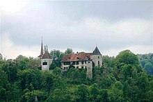
The castle of Surpierre stands on the rocky ledge between the Broyetal and the valley of the Dorfbach and is separated from the plateau of Surpierre by a moat. The core of the castle dates back to the 13th century. The oldest parts include a residential tower and the foundation walls of the keep. The other facilities were rebuilt after a fire in 1544, including the residential and commercial buildings and the gate tower, and adapted for the purposes of the time as the bailiff's seat.
The core of the parish church of Surpierre dates from the 16th century and was later changed several times. Some farmhouses from the 17th to 19th centuries have been preserved in the town center.
Web links
- Aerial views of the village and its surroundings
- Castle world: Château de Surpierre
- Marianne Rolle: Surpierre. In: Historical Lexicon of Switzerland .
Individual evidence
- ↑ Permanent and non-permanent resident population by year, canton, district, municipality, population type and gender (permanent resident population). In: bfs. admin.ch . Federal Statistical Office (FSO), August 31, 2019, accessed on December 22, 2019 .


