
Prévondavaux
| Prévondavaux | |
|---|---|
 |
|
| State : |
|
| Canton : |
|
| District : | Broye |
| BFS no. : | 2038 |
| Postal code : | 1410 |
| Coordinates : | 550 672 / 175 380 |
| Height : | 688 m above sea level M. |
| Height range : | 616–777 m above sea level M. |
| Area : | 1.82 km² |
| Residents: | 65 (December 31, 2018) |
| Population density : | 36 inhabitants per km² |
| Website: | www.prevondavaux.ch |
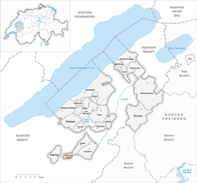
 Prévondavaux |
|
| Location of the municipality | |
  |
|
Prévondavaux ( Friborg Patois ) is a municipality in the Broye district in the canton of Friborg in Switzerland . The former German place name Tiefental is no longer used today.
geography
Prévondavaux lies at 688 m above sea level. M. , 7 km north of Moudon (as the crow flies) in the Friborg exclave Surpierre . The small farming village extends on the western slope of the Lembe , in the Molasse hills of the western Freiburg Central Plateau .
The area of the municipal area of 1.8 km² covers a section of the Molasse hill country between Lake Neuchâtel and the central Broyetal . The Lembe flows through the area from southwest to northeast in a relatively wide basin. To the west, the municipality extends up to the height of La Montagne , on which in the forest Bois de Montfrioud with 775 m above sea level. M. the highest point of Prévondavaux is reached. In the east the area extends in the Bois des Charbonnies (up to 760 m above sea level ) on the ridge between the valleys of Lembe and Broye. In 1997, 3% of the municipal area was accounted for by settlements, 30% for forests and woodlands and 67% for agriculture.
Some individual farms belong to Prévondavaux. Neighboring municipalities of Prévondavaux are Cheiry in the canton of Friborg and Forel-sur-Lucens , Villars-le-Comte , Denezy and Combremont-le-Petit in the canton of Vaud .
population
With 65 inhabitants (as of December 31, 2018), Prévondavaux is the smallest municipality in the canton of Friborg in terms of population. 90.5% of the residents speak French, 7.9% speak German and 1.6% speak Italian (as of 2000). The population of Prévondavaux was 123 in 1900. In the course of the 20th century, the population decreased continuously by two thirds to 41 inhabitants due to strong emigration until 1970. Since then a slight population growth has been recorded again.
economy
Until the second half of the 20th century, Prévondavaux was predominantly an agricultural village. A sawmill used to be operated by the water power of the Lembe. Even today, agriculture and fruit growing, as well as dairy farming and cattle breeding, have an important place in the income structure of the population. Some other jobs are available in local small businesses and in the service sector. Some workers are also commuters who work in the larger parts of the Broye Valley.
traffic
The community is located off the main thoroughfares on a connecting road from Granges-près-Marnand to Thierrens . Prévondavaux itself has no connection to the public transport network.
history
The first written mention of the place took place in 1177 under the Latinized name Profunda valle (deep valley). Since the Middle Ages, Prévondavaux has been under the rule of Surpierre. With this, the village came on February 21, 1536 to Bern and on March 1, 1536 under the rule of Freiburg, where it was assigned to the Bailiwick of Surpierre. After the collapse of the Ancien Régime (1798), Prévondavaux belonged to the Estavayer district during the Helvetic Republic until 1803 and then to the Surpierre district before it was incorporated into the Broye district in 1848. The village has a chapel, but belongs to the parish of Vuissens .
Attractions
Web links
- Marianne Rolle: Prévondavaux. In: Historical Lexicon of Switzerland .
- Official website of the municipality of Prévondavaux
Individual evidence
- ↑ Permanent and non-permanent resident population by year, canton, district, municipality, population type and gender (permanent resident population). In: bfs. admin.ch . Federal Statistical Office (FSO), August 31, 2019, accessed on December 22, 2019 .
Belmont-Broye | Châtillon | Cheiry | Cheyres-Châbles | Cugy | Delley Portalban | Estavayer | Fétigny | Gletterens | Les Montets | Lully | Ménières | Montagny | Nuvilly | Prévondavaux | Saint-Aubin | Sévaz | Surpierre | Vallon
Former municipalities: Aumont | Autavaux | Bollion | Bussy | Châbles | Chandon | Chapelle (Broye) | Cheyres | Delley | Domdidier | Dompierre | Estavayer-le-Lac | Font | Forel | Franex | Frasses | Granges-de-Vesin | La Vounaise | Léchelles | Les Friques | Mannens-Grandsivaz | Montagny-la-Ville | Montagny-les-Monts | Montborget | Montbrelloz | Montet (Broye) | Morens | Murist | Portalban | Praratoud | Rueyres-les-Prés | Russy | Seiry | Vernay | Vesine | Villeneuve | Vuissens
Canton of Friborg | Districts of the canton of Friborg | Municipalities of the canton of Friborg