
Châbles
| Châbles | ||
|---|---|---|
 |
||
| State : |
|
|
| Canton : |
|
|
| District : | Broye district | |
| Municipality : | Cheyres-Châbles | |
| Postal code : | 1474 | |
| former BFS no. : | 2005 | |
| Coordinates : | 551885 / 186 240 | |
| Height : | 571 m above sea level M. | |
| Area : | 4.80 km² | |
| Residents: | 788 (December 31, 2016) | |
| Population density : | 164 inhabitants per km² | |
| Website: | www.cheyres-chables.ch | |
 Châbles |
||
| map | ||
|
||


Châbles ( Friborg Patois ) was a municipality in the Broye district of the canton of Friborg in Switzerland until December 31, 2016 . On January 1, 2017, Châbles merged with the municipality of Cheyres to form the new municipality of Cheyres-Châbles .
geography
Châbles is a village within the enclave of the canton of Friborg. The community is located directly on Lake Neuchâtel opposite the Jura chain. A total of three Freiburg municipalities, Lully (FR) , Châtillon and Estavayer-le-Lac, border the municipality. The construction of the A1 motorway very close by has greatly changed the landscape.
- Highest point: 650 m
- Lowest point: 429 m
population
languages
A small minority of around 10% speaks German. Otherwise the population is French-speaking.
Religions - denominations
More than 60% of the population is Roman Catholic. A larger minority of 20% is Protestant. The remaining 20% are mostly non-denominational.
economy
More than half of the employees work in the primary sector (agriculture). With the construction of the A1 motorway, new households have settled. The increase in the number of employees is mainly taking place in the industrial and service sectors.
tourism
Tourism has also increased in recent years. Tourists are particularly drawn to the proximity of Lake Neuchâtel and the tranquility of the area.
traffic
A regular bus service operated by the Transports publics fribourgeois connects Châbles with Estavayer-le-Lac . With the A1, it has become much easier to get to Bern or Lausanne.
history

The area around Châbles was populated very early. At La Cernia on the eastern edge of the municipality, a two-lane Roman road was discovered during the construction of the motorway.
In 1628 by the plague and in 1642 by a conflagration, Châbles was badly affected. Until 1798 Châbles belonged to the Bailiwick of Font and Vuissens. In 1801 the Grande Commune Font-Châbles-Châtillon was dissolved. In 1809 the statutes of the community are established.
Attractions
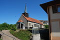
church

church

Interior of the church
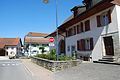
Village center
Village center

school
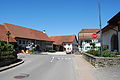
Coming from Granges des Cheyres

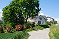
Stately farmhouse in the village center
_282.JPG)
_284.JPG)
_286.JPG)
_278.JPG)
_274.JPG)
_294.JPG)
_269.JPG)
_300.JPG)
literature
- Le district de la Broye fribourgeoise a 150 ans (1848-1998), Imprimerie Butty, Estavayer-le-Lac
Web links
- Official website of the municipality of Châbles
- Gérard Guisolan: Châbles. In: Historical Lexicon of Switzerland .
- Statistics Freiburg
Belmont-Broye | Châtillon | Cheiry | Cheyres-Châbles | Cugy | Delley Portalban | Estavayer | Fétigny | Gletterens | Les Montets | Lully | Ménières | Montagny | Nuvilly | Prévondavaux | Saint-Aubin | Sévaz | Surpierre | Vallon
Former municipalities: Aumont | Autavaux | Bollion | Bussy | Châbles | Chandon | Chapelle (Broye) | Cheyres | Delley | Domdidier | Dompierre | Estavayer-le-Lac | Font | Forel | Franex | Frasses | Granges-de-Vesin | La Vounaise | Léchelles | Les Friques | Mannens-Grandsivaz | Montagny-la-Ville | Montagny-les-Monts | Montborget | Montbrelloz | Montet (Broye) | Morens | Murist | Portalban | Praratoud | Rueyres-les-Prés | Russy | Seiry | Vernay | Vesine | Villeneuve | Vuissens
Canton of Friborg | Districts of the canton of Friborg | Municipalities of the canton of Friborg