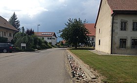
Autavaux
| Autavaux | ||
|---|---|---|
| State : |
|
|
| Canton : |
|
|
| District : | Broye | |
| Municipality : | Vernay | |
| Postal code : | 1475 | |
| former BFS no. : | 2002 | |
| Coordinates : | 557194 / 190 615 | |
| Height : | 450 m above sea level M. | |
| Area : | 1.42 km² | |
| Residents: | 229 (December 31, 2005) | |
| Population density : | 161 inhabitants per km² | |
|
Autavaux |
||
| map | ||
|
|
||
Autavaux is a town and formerly an independent political municipality in the Broye district of the canton of Friborg in Switzerland . With effect from January 1, 2006, Autavaux was merged with Montbrelloz and Forel (FR) to form the new municipality of Vernay . The village has been part of the Estavayer municipality since 2017 .
geography
Autavaux is about five kilometers from Estavayer-le-Lac and is located in the exclave of the same name. It towers over Lake Neuchâtel a little behind the adjacent rocks.
- Highest point: 493 m
- Lowest point: 429 m
population
The village has 229 inhabitants (2005). The population is predominantly French-speaking. 75% of the population is Roman Catholic and around 20% Protestant.
economy
Approx. 50% of the employees work in agriculture. Another 30% work in the service sector and 20% in industry and commerce.
history
Autavaux is first mentioned in writing around 1350. Several documents from 1383, 1442 and 1504 prove that the lords of the village belonged to the noble family d'Estavayer.
Attractions
literature
- Le district de la Broye fribourgeoise a 150 ans (1848–1998), Imprimerie Butty, Estavayer-le-Lac
Web links
- Marianne Rolle: Autavaux. In: Historical Lexicon of Switzerland .
- Statistics Freiburg


