
Châtillon FR
| FR is the abbreviation for the canton of Friborg in Switzerland and is used to avoid confusion with other entries of the name Châtillon . |
| Châtillon | |
|---|---|
 |
|
| State : |
|
| Canton : |
|
| District : | Broye |
| BFS no. : | 2008 |
| Postal code : | 1473 |
| Coordinates : | 553 248 / 187 062 |
| Height : | 515 m above sea level M. |
| Height range : | 494–609 m above sea level M. |
| Area : | 1.30 km² |
| Residents: | 466 (December 31, 2018) |
| Population density : | 358 inhabitants per km² |
| Website: | www.chatillon-broye.ch |
.JPG) Châtillon |
|
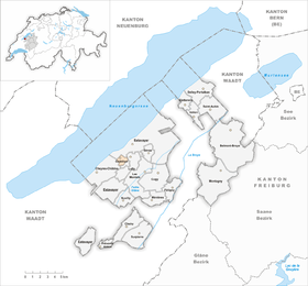
| Location of the municipality | |
  |
|
Châtillon is a municipality in the Broye district in the canton of Friborg in Switzerland .
geography
Châtillon is separated from Lake Neuchâtel by the former municipality of Font , which now belongs to Estavayer . Châtillon also borders on Cheyres-Châbles and Lully . From the village Le Purgatoire a panoramic view is possible from the Jura to the Mont Blanc .
- Highest point: 607 m
- Lowest point: 495 m
population
languages
86% of the population speak mainly French. German is spoken by around 11.5% of the population; in addition, a small minority of 2.2% speaks Italian.
Religions - denominations
At 64%, the majority of the population belong to the Roman Catholic denomination. Another 25% of the population profess Protestantism. The remaining inhabitants are not religious or belong to other religious communities.
economy
More than three quarters of the population work in the service sector. There are still four intact farms.
history
Archaeological excavations in La Vuardaz show that the place was settled before the Gallo-Roman period. The municipality has been autonomous since 1801. In 1990, the Grac reservoir was put into operation at the summit of la Crête , which makes it possible to supply ten neighboring communities with 680,000 m³ of drinking water per year.
Attractions
literature
- Le district de la Broye fribourgeoise a 150 ans (1848–1998), Imprimerie Butty, Estavayer-le-Lac
Web links
- Official website of the municipality of Châtillon (Broye)
- Gérard Guisolan: Châtillon (FR). In: Historical Lexicon of Switzerland .
- Statistics Freiburg
Individual evidence
- ↑ Permanent and non-permanent resident population by year, canton, district, municipality, population type and gender (permanent resident population). In: bfs. admin.ch . Federal Statistical Office (FSO), August 31, 2019, accessed on December 22, 2019 .
Belmont-Broye | Châtillon | Cheiry | Cheyres-Châbles | Cugy | Delley Portalban | Estavayer | Fétigny | Gletterens | Les Montets | Lully | Ménières | Montagny | Nuvilly | Prévondavaux | Saint-Aubin | Sévaz | Surpierre | Vallon
Former municipalities: Aumont | Autavaux | Bollion | Bussy | Châbles | Chandon | Chapelle (Broye) | Cheyres | Delley | Domdidier | Dompierre | Estavayer-le-Lac | Font | Forel | Franex | Frasses | Granges-de-Vesin | La Vounaise | Léchelles | Les Friques | Mannens-Grandsivaz | Montagny-la-Ville | Montagny-les-Monts | Montborget | Montbrelloz | Montet (Broye) | Morens | Murist | Portalban | Praratoud | Rueyres-les-Prés | Russy | Seiry | Vernay | Vesine | Villeneuve | Vuissens
Canton of Friborg | Districts of the canton of Friborg | Municipalities of the canton of Friborg