
Lully FR
| FR is the abbreviation for the canton of Friborg in Switzerland and is used to avoid confusion with other entries of the name Lully . |
| Lully | |
|---|---|
 |
|
| State : |
|
| Canton : |
|
| District : | Broye |
| BFS no. : | 2025 |
| Postal code : | 1470 |
| Coordinates : | 554 689 / 187082 |
| Height : | 494 m above sea level M. |
| Height range : | 472–628 m above sea level M. |
| Area : | 5.50 km² |
| Residents: | 1141 (December 31, 2018) |
| Population density : | 207 inhabitants per km² |
| Website: | www.lully-fr.ch |
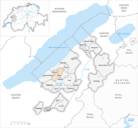
| Location of the municipality | |
  |
|
Lully is a municipality in the Broye district in the canton of Friborg in Switzerland . On January 1, 2006, the formerly independent communities Bollion and Seiry were incorporated into Lully.
geography
Lully is 494 m above sea level. M. , 1.5 km south of the district capital Estavayer-le-Lac (air line). The village extends on the plateau south of Lake Neuchâtel , at the northeastern foot of the Molasse Heights between the lake and the Broyetal , in the northwestern Freiburg Central Plateau .
The area of the 5.4 km² municipal area covers a section of the Freiburg Central Plateau. The northern part of the area is occupied by the plateau on which Lully lies. To the southeast, the municipality extends into the lowlands of the Arignon (side stream of the Petite Glâne ) and to the south over the forest area Bois de Mussillens ( 541 m above sea level ) into the valley of the Bainoz .
Since the municipal merger, part of the Bainoztal in the Molasse hill country south of Estavayer-le-Lac has also belonged to Lully. The highest elevations of Lully are reached on the high plateau of Seiry with the corridors La Lovataire ( 626 m above sea level ) and Champs Dessus ( 628 m above sea level ). This plateau drops steeply towards the south to the valley of the Petite Glâne. In 1997, 9% of the municipal area was accounted for by settlements, 21% for forests and woodlands and 70% for agriculture.
The municipality of Lully consists of the following localities:
- Lully , 494 m above sea level M. , on the plateau south of Estavayer-le-Lac, 380 inhabitants
- Bollion , 559 m above sea level M. , in the valley of the Bainoz, 134 inhabitants
- Seiry , 605 m above sea level M. , on the high plateau between the valleys of Bainoz and Petite Glâne, 202 inhabitants
Lully's neighboring municipalities are Estavayer-le-Lac , Les Montets , Murist and Châbles .

population
Lully is one of the smaller communities in the canton of Friborg. 88.2% of the residents are French-speaking, 5.7% German-speaking and 2.5% speak Italian (as of 2000). The population of Lully was 370 in 1850 and 425 in 1900 (including Bollion and Seiry). In the course of the 20th century, the population decreased to 320 people by 1960. Since then there has been a rapid population growth combined with a doubling of the population within 30 years. Today, the settlement area of the village of Lully has almost completely merged with that of Estavayer-le-Lac.
economy
Until the second half of the 20th century, Lully was a predominantly agricultural village. Even today arable farming , fruit growing and cattle breeding have a certain place in the income structure of the population. Further jobs are available in local small businesses and in the service sector. The Rose de la Broye service area, which opened in 2001, is located on the A1 motorway in the municipality. In the past few decades, Lully has also developed into a residential community. Most of the employed are therefore commuters who work mainly in the Estavayer-le-Lac and Payerne regions.
traffic
The community is located off the major thoroughfares on a connecting road from Estavayer-le-Lac to Murist . The next connection to the A1 motorway (Lausanne-Bern), which opened in 2001 and crosses the municipality, is around 3 km from the town center. Lully is connected to the public transport network by the Transports publics Fribourgeois bus line , which serves the hinterland from Estavayer-le-Lac on a circular route.
history
The municipality of Lully was settled very early, which has been confirmed by finds of settlement traces from Roman times . The place was first mentioned in a document in 516 under the name Luliacum . Later the names Lulliaco (1011), Lulliacum (1017), Lulie (1228), Lulye (1285), Lulliez (1520) and Lullie (1668) appeared. The place name goes back to the Gallo-Roman personal name Lullius .
Lully came into the possession of the Abbey of Saint-Maurice as early as 516 by the Burgundian kings . Since the 11th century, the church has belonged to the Romainmôtier monastery . The lords of Estavayer held the secular rule. After Bern conquered Vaud in 1536, Lully was assigned to the Estavayer Bailiwick. After the collapse of the Ancien Régime (1798), the village was part of the Estavayer district during the Helvetic and subsequent periods before being incorporated into the Broye district in 1848. The village has been an independent parish since 1860.

As part of the community mergers funded by the canton of Friborg since 2000, a merger project was developed with the aim of merging Bollion and Seiry with Lully. At the community meetings on April 22, 2005, the merger was approved by the voters of all three communities, but in Lully with a yes share of just 53%. The merger was completed with effect from January 1, 2006. At the same time, the new overall community received a new coat of arms.
Attractions
Web links
- Official website of the municipality of Lully FR
- Marianne Rolle: Lully (FR). In: Historical Lexicon of Switzerland .
- Community information
Individual evidence
- ↑ Permanent and non-permanent resident population by year, canton, district, municipality, population type and gender (permanent resident population). In: bfs. admin.ch . Federal Statistical Office (FSO), August 31, 2019, accessed on December 22, 2019 .
Belmont-Broye | Châtillon | Cheiry | Cheyres-Châbles | Cugy | Delley Portalban | Estavayer | Fétigny | Gletterens | Les Montets | Lully | Ménières | Montagny | Nuvilly | Prévondavaux | Saint-Aubin | Sévaz | Surpierre | Vallon
Former municipalities: Aumont | Autavaux | Bollion | Bussy | Châbles | Chandon | Chapelle (Broye) | Cheyres | Delley | Domdidier | Dompierre | Estavayer-le-Lac | Font | Forel | Franex | Frasses | Granges-de-Vesin | La Vounaise | Léchelles | Les Friques | Mannens-Grandsivaz | Montagny-la-Ville | Montagny-les-Monts | Montborget | Montbrelloz | Montet (Broye) | Morens | Murist | Portalban | Praratoud | Rueyres-les-Prés | Russy | Seiry | Vernay | Vesine | Villeneuve | Vuissens
Canton of Friborg | Districts of the canton of Friborg | Municipalities of the canton of Friborg