
Saint-Aubin FR
| FR is the abbreviation for the canton of Friborg in Switzerland and is used to avoid confusion with other entries of the name Saint-Aubin . |
| Saint-Aubin | |
|---|---|
 |
|
| State : |
|
| Canton : |
|
| District : | Broye |
| BFS no. : | 2041 |
| Postal code : | 1566 |
| Coordinates : | 565089 / 193312 |
| Height : | 471 m above sea level M. |
| Height range : | 429-530 m above sea level M. |
| Area : | 7.89 km² |
| Residents: | 1801 (December 31, 2018) |
| Population density : | 228 inhabitants per km² |
| Website: | www.st-aubin.ch |
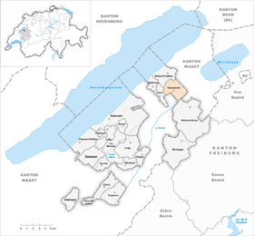
| Location of the municipality | |
  |
|
Saint-Aubin ( Friborg Patois ) is a municipality in the Broye district in the canton of Friborg in Switzerland . The former German name Sankt Albin is no longer used today.
geography
Saint-Aubin is located at 471 m above sea level. M. , 9 km north-northeast of Payerne (linear distance). The clustered village extends from a promising location on the slightly south-sloping slope north of the Broye plain , in the north-western Freiburg Central Plateau .
The area of the 7.9 km² municipal area includes a section of the ridge that separates Lake Neuchâtel from the Broye plain. The southern part of the municipality lies in the Broye plain (around 435 m above sea level ) and extends over the canalized river course of the Petite Glâne to the Broye. To the north, the municipality extends over the gently sloping slope of Saint-Aubin to the broad Molasse ridges , with the western boundary in the valley of the Ruisseau des Vaux , the eastern in the valley system of Les Friques. On the corridor Sur le Mont is 525 m above sea level. M. reached the highest point of Saint-Aubin. In 1997, 10% of the municipal area was in settlements, 6% in forests and woodlands, 83% in agriculture and a little more than 1% was unproductive land.
The village of Les Friques ( 475 m above sea level ), which has grown together with Villars-le-Grand, and some individual farms belong to Saint-Aubin . The neighboring municipalities of Saint-Aubin are Belmont-Broye , Vallon and Delley-Portalban in the canton of Friborg and Missy , Vully-les-Lacs and Avenches in the canton of Vaud .
population
With 1801 inhabitants (as of December 31, 2018), Saint-Aubin is one of the medium-sized municipalities in the canton of Friborg. 88.9% of the residents are French-speaking, 6.1% German-speaking and 1.5% speak Albanian (as of 2000). The population of Saint-Aubin was 664 in 1900. In the course of the 20th century, the population fluctuated between 650 and 720 inhabitants. Only since 1960 (650 inhabitants) has rapid population growth been recorded, combined with a doubling of the number of inhabitants within 40 years.
economy
Until the second half of the 20th century, Saint-Aubin was a predominantly agricultural village. Even today, arable farming , fruit growing and animal husbandry have an important place in the income structure of the population. There are some small wine-growing areas on the slopes that are optimally sloping towards the south . There is a large horticultural company in the Broye plain.
Further jobs are available in local small businesses and in the service sector. Since the 1970s, some new companies have set up in Saint-Aubin. Today mechanical workshops, carpenters, construction companies and a distillery are represented in the village. The construction of a large leisure and entertainment center (Family Land) is planned near Saint-Aubin. In the last few decades the village has also developed into a residential community thanks to its attractive location. Many workers are therefore commuters who work mainly in the Payerne and Freiburg regions.
traffic

The community has good transport links. It is located on the main road from Estavayer-le-Lac to Avenches or Cudrefin . The closest connection to the A1 motorway (Lausanne-Bern), which opened in 1997, is around 5 km from the town center. Saint-Aubin is connected to the public transport network by a bus from the Transports publics Fribourgeois , which runs from Domdidier as a circular route.
history
The municipality of Saint-Aubin was already settled in Roman times, which was proven by the discovery of bricks and remains of a sewer system. The first written mention of the place took place in 1228 under the name Sanctus Albinus en Willie ; the place was probably inhabited much earlier. The place name goes back to Bishop Albin von Tours, who died in 550.
Since the Middle Ages , Saint-Aubin formed its own small lordship that was under the influence of the Counts of Savoy . After Bern had conquered the Vaud in 1536, the village came under the rule of Friborg and was converted into an independent bailiwick that only included Saint-Aubin and Les Friques. After the collapse of the Ancien Régime (1798), Saint-Aubin belonged to the Avenches district during the Helvetic period , to the Montagny district from 1803 and to the Dompierre district from 1830, before being incorporated into the Broye district in 1848. With effect from January 1, 1991, the previously independent Les Friques was incorporated into Saint-Aubin.
Attractions

The Catholic parish church of Saint-Aubin, which was mentioned as early as the 11th century, stands on the large village square. The church was given its current shape when it was rebuilt at the beginning of the 16th century, and the tower was added in 1630. The three-aisled building has a polygonal choir and partly Gothic furnishings (tabernacle, baptismal font).
Opposite the church is the Saint-Aubin castle, built in 1631. The massive rectangular building is flanked by four square corner towers and a polygonal stair tower. Some stately farmhouses from the 17th to 19th centuries have been preserved in the town center.
Web links
- Official website of the municipality of Saint-Aubin (French)
- Aerial views of the village
- Marianne Rolle: Saint-Aubin (FR). In: Historical Lexicon of Switzerland .
Individual evidence
- ↑ Permanent and non-permanent resident population by year, canton, district, municipality, population type and gender (permanent resident population). In: bfs. admin.ch . Federal Statistical Office (FSO), August 31, 2019, accessed on December 22, 2019 .
Belmont-Broye | Châtillon | Cheiry | Cheyres-Châbles | Cugy | Delley Portalban | Estavayer | Fétigny | Gletterens | Les Montets | Lully | Ménières | Montagny | Nuvilly | Prévondavaux | Saint-Aubin | Sévaz | Surpierre | Vallon
Former municipalities: Aumont | Autavaux | Bollion | Bussy | Châbles | Chandon | Chapelle (Broye) | Cheyres | Delley | Domdidier | Dompierre | Estavayer-le-Lac | Font | Forel | Franex | Frasses | Granges-de-Vesin | La Vounaise | Léchelles | Les Friques | Mannens-Grandsivaz | Montagny-la-Ville | Montagny-les-Monts | Montborget | Montbrelloz | Montet (Broye) | Morens | Murist | Portalban | Praratoud | Rueyres-les-Prés | Russy | Seiry | Vernay | Vesine | Villeneuve | Vuissens
Canton of Friborg | Districts of the canton of Friborg | Municipalities of the canton of Friborg