Denezy
| Denezy | ||
|---|---|---|
| State : |
|
|
| Canton : |
|
|
| District : | Gros-de-Vaud | |
| Municipality : | Montanaire | |
| Postal code : | 1410 | |
| former BFS no. : | 5670 | |
| Coordinates : | 549 923 / 174 645 | |
| Height : | 744 m above sea level M. | |
| Area : | 3.79 km² | |
| Residents: | 128 (December 31, 2012) | |
| Population density : | 34 inhabitants per km² | |
|
Denezy |
||
| map | ||
|
|
||
Until December 31, 2012, Denezy was a municipality in the Gros-de-Vaud district of the canton of Vaud in Switzerland .
On January 1, 2013, it merged with the municipalities of Chanéaz , Chapelle-sur-Moudon , Correvon , Martherenges , Neyruz-sur-Moudon , Peyres-Possens , Saint-Cierges and Thierrens to form the new municipality of Montanaire .
geography
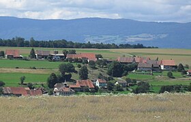
Denezy is 744 m above sea level. M. , 25 km northeast of the canton capital of Lausanne (linear distance). The farming village extends on the western slope of the upper Lembe , in the Molasse hill country between the Mentue and the Broye , in the Vaud Central Plateau .
The area of the 3.8 km² former municipal area comprises a section in the upper (south-western) part of the Lembe valley. This brook flows through the area from southwest to northeast in a relatively wide valley basin , which is accompanied in the east by the height of Villars-le-Comte and in the west by the La Roseire plateau . In the south, the former municipal soil extends into the Chalembert forest in the headwaters of the Lembe. The highest point of Denezy is 808 m above sea level. M. on the plateau La Roseire, which continues to the northeast in the forest Bois de Montfrioud ( 795 m above sea level ). In 1997, 5% of the former municipal area was accounted for by settlements, 23% for forests and woodlands and 72% for agriculture.
Denezy consists of three districts that have practically grown together. The lower part of the village with the church is located near the valley floor of the Lembe, the center with the schoolhouse is on the main road and the upper part of the village is on the edge of the high plateau. In addition, several individual farms belong to the former community. Neighboring communities of Denezy were Thierrens , Neyruz-sur-Moudon , Villars-le-Comte and Combremont-le-Petit in the canton of Vaud and Prévondavaux and Vuissens in two different exclaves in the canton of Friborg .
population
With 128 inhabitants (as of the end of 2012), Denezy was one of the smallest municipalities in the canton of Vaud. 91.8% of the residents are French-speaking, 5.7% German-speaking and 0.8% Italian-speaking (as of 2000). The population of Denezy was 253 in 1850, and 247 in 1900. Thereafter, a decrease of around 50% to 129 inhabitants was recorded by 1970 due to strong emigration; since then the population has remained stable.
economy
Until the second half of the 20th century, Denezy was predominantly an agricultural village. Even today, arable farming , fruit growing and cattle breeding play an important role in the income structure of the population. Further jobs are available in local small businesses and in the service sector. There used to be a mill and a sawmill on the Lembe. In the last few decades the village has also developed into a residential community. Some workers are therefore commuters who work in the surrounding larger towns.
traffic
The former municipality is located off the major thoroughfares on a connecting road from Thierrens to Granges-près-Marnand . Denezy is connected to the public transport network through the Postbus course that runs from Moudon to Thierrens.
history
The first documentary mention of the place took place in 929 under the name villare Donaciaco . Later numerous other spellings appeared: Danisei (1142), Donesie (1169), Danusiacum (1179), Dunesie (1188), Deneisie (1228), Danaisie in the 13th century, Denisiez (1453) and Dinisiez (1555). The place name is derived from the Latin gender name Donat (i) us .
Denezy formed its own rule under the influence of the Dukes of Savoy . They handed the village over to the Cerjat family in 1409, who ruled the village until 1798. With the conquest of Vaud by Bern in 1536, Denezy came under the administration of the Moudon Bailiwick , where it was the seat of a court of law. After the collapse of the Ancien Régime , the village belonged to the canton of Léman from 1798 to 1803 during the Helvetic Republic , which then became part of the canton of Vaud when the mediation constitution came into force . In 1798 it was assigned to the Moudon district.
Attractions
A chapel has been mentioned since the first mention of the village, which was later expanded to become a parish church. The current building dates from the 15th century, was later restored several times and contains wall and glass paintings by L. Rivier (1925). The school building with a bell tower was built in 1900. Only small remains of ramparts and foundation walls are left of the former castle near Creux du château.


