Lussery-Villars
| Lussery-Villars | |
|---|---|
| State : |
|
| Canton : |
|
| District : | Gros-de-Vaud |
| BFS no. : | 5487 |
| Postal code : | 1307 |
| Coordinates : | 530 101 / 165023 |
| Height : | 494 m above sea level M. |
| Height range : | 432–571 m above sea level M. |
| Area : | 3.74 km² |
| Residents: | 462 (December 31, 2018) |
| Population density : | 124 inhabitants per km² |
| Website: | www.lussery-villars.ch |
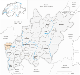
| Location of the municipality | |
Lussery-Villars is a municipality in the Gros-de-Vaud district in the canton of Vaud in Switzerland . The double community was created on January 1, 1999 through the merger of the previously independent communities Lussery and Villars-Lussery .
geography
Lussery-Villars is 494 m above sea level. M. , 2.5 km north-east of Cossonay and 15 km north-west of the canton capital Lausanne (linear distance). The village extends on the western slope of the Venoge , in the Gros de Vaud , in the Vaud Central Plateau .
The area of the 3.7 km² municipal area includes a section of the Gros de Vaud, the granary of the canton of Vaud. The municipality floor extends from the wide valley of the middle Venoge to the west up the slope of Lussery-Villars to the adjacent high plateau, on which at 571 m above sea level. M. the highest point of the municipality is reached. In 1997, 6% of the municipal area was accounted for by settlements, 9% for forests and woodlands, 84% for agriculture and a little more than 1% was unproductive land.
Lussery-Villars consists of the two villages Lussery ( 494 m above sea level ) and Villars ( 492 m above sea level ) halfway up on the slope west of the Venoge and a few individual farms. The neighboring communities of Lussery-Villars are in the southwest Cossonay , in the west Dizy , in the northwest La Sarraz , in the north Eclépen , in the east Daillens and in the south Penthalaz .
population
With 462 inhabitants (as of December 31, 2018) Lussery-Villars is one of the small communities in the canton of Vaud. 93.9% of the residents are French-speaking, 2.8% German-speaking and 1.2% Italian-speaking (as of 2000). The population of Lussery-Villars was 286 in 1900. After the population had decreased to 178 people by 1980, a significant increase in population was recorded again. 1997 Lussery had 168 inhabitants and Villars-Lussery 156 inhabitants.
economy
Lussery and Villars-Lussery were predominantly agricultural villages until the second half of the 20th century . Even today, the have farming and fruit growing an important role in the employment structure of the population. Further jobs are available in local small businesses and in the service sector. There is a blacksmith's workshop in the village. A mill has existed on the Venoge below Lussery since the 17th century. In the last few decades Lussery-Villars has developed into a residential community. Many workers are therefore commuters who work in the surrounding villages and in the greater Lausanne area.
traffic
The community is very well developed in terms of traffic, although it is located away from major thoroughfares. Road connections exist to Cossonay , Eclépens and Penthalaz . The motorway connections La Sarraz and Cossonay on the A1 (Lausanne-Yverdon) opened in 1981 are each around 6 km from the village. The villages are connected to the public transport network by a bus line to Cossonay-Gare .
history
The first written mention of the village Lussery took place in 1147 under the name Luseri . At the beginning of the 13th century the name Luxirie appeared , then Lussirie (1230), Luxirier and Luxurie (1387), Luxurier (1461) and Luxiry (1699). The place name goes back to the personal name Luxurius .
In the Middle Ages , the Lausanne Cathedral Chapter and the Lac de Joux Abbey ( L'Abbaye ) owned land on the territory of the villages. Since the late 13th century, Lussery and Villars-Lussery formed a rule that was temporarily under the sovereignty of the Lords of Cossonay , and later under that of the Lords of La Sarraz. In 1664 the rule was divided. While Lussery aligned himself to Cossonay in the following years, Villars-Lussery remained in the sphere of influence of the rule of Eclépen and formed its own rule after 1674.
With the conquest of Vaud by Bern in 1536, Lussery came under the administration of the Bailiwick of Morges . After the collapse of the Ancien Régime , the villages belonged to the canton of Léman from 1798 to 1803 during the Helvetic Republic, which then became part of the canton of Vaud when the mediation constitution came into force . In 1798 they were assigned to the Cossonay district.
On January 1, 1999, the two municipalities merged.
Attractions
The old mill on the Venoge with large paddle wheels dates from the 17th century. On the field between the villages of Lussery and Villars-Lussery, the new reformed church was built in the 1990s. In the villages there are still some farmhouses from the 18th and 19th centuries.
Web links
- Official website of the municipality of Lussery-Villars (French)
- François Béboux: Lussery. In: Historical Lexicon of Switzerland .
- Editor: Lussery-Villars. In: Historical Lexicon of Switzerland .
- Aerial photography
Individual evidence
- ↑ Permanent and non-permanent resident population by year, canton, district, municipality, population type and gender (permanent resident population). In: bfs. admin.ch . Federal Statistical Office (FSO), August 31, 2019, accessed on December 22, 2019 .


