Chapelle-sur-Moudon
| Chapelle-sur-Moudon | ||
|---|---|---|
| State : |
|
|
| Canton : |
|
|
| District : | Gros-de-Vaud | |
| Municipality : | Montanaire | |
| Postal code : | 1063 | |
| former BFS no. : | 5664 | |
| Coordinates : | 546 133 / 168872 | |
| Height : | 759 m above sea level M. | |
| Area : | 4.63 km² | |
| Residents: | 405 (December 31, 2012) | |
| Population density : | 87 inhabitants per km² | |
| map | ||
|
|
||
Chapelle-sur-Moudon was until December 31, 2012 a municipality in the Gros-de-Vaud district of the canton of Vaud in Switzerland . Until 1953 the community was officially called Chapelle (VD) , in the Middle Ages, especially under the Bernese rule, Chapelle-Vaudanne .
On January 1, 2013, it merged with the municipalities of Chanéaz , Correvon , Denezy , Martherenges , Neyruz-sur-Moudon , Peyres-Possens , Saint-Cierges and Thierrens to form the new municipality of Montanaire .
geography
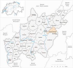
Chapelle-sur-Moudon lies at 759 m above sea level. M. , 17 km north of the canton capital Lausanne (linear distance). The village extends over a wide plateau north of the Jorat , between the valley cuts of the Mentue in the west and the Mérine in the east, in the Molasse hills of the northern Vaud Central Plateau .
The area of the 4.6 km² former municipal area comprises a section of the high plateau between the Mentue and the central Broyetal . The plateau is slightly wavy and lies at an average altitude of 760 m above sea level. M. It is drained to the northwest by the Oulaire brook to the Mentue; southeast of the village, the Tenette , a side stream of the Mérine, has carved an erosion valley into the plateau. To the north, the former municipality extends into the forest of Les Biolettes, where it reaches 838 m above sea level. M. the highest point of Chapelle-sur-Moudon. To the east, the area extends to the edge of the Bois de Planche Signal forest . In 1997, 7% of the former municipal area was accounted for by settlements, 13% for forests and woodlands and 80% for agriculture.
Chapelle-sur-Moudon includes the hamlet of La Combe ( 731 m above sea level ) above Peyres-Possens and several individual farms. Neighboring communities of Chapelle-sur-Moudon were Saint-Cierges , Moudon , Martherenges , Sottens , Peyres-Possens and Boulens .
population
With 405 inhabitants (as of the end of 2012), Chapelle-sur-Moudon was one of the small communities in the canton of Vaud. 94.0% of the residents are French-speaking, 2.8% Portuguese-speaking and 2.2% German-speaking (as of 2000). The population of Chapelle-sur-Moudon was 368 in 1850 and 323 in 1900. Thereafter, a further decrease of around a third to 224 inhabitants was recorded by 1970; since then the population has increased significantly again.
economy
Until the second half of the 20th century, Chapelle-sur-Moudon was a predominantly agricultural village. Even today, arable farming , fruit growing and cattle breeding play an important role in the income structure of the population. Further jobs are available in local small businesses and in the service sector, including mainly in the construction industry and in a publishing house. The drilling for crude oil carried out on the high plateau in 1958 was unsuccessful. In the last few decades the village has also developed into a residential community. Some workers are commuters who work mainly in Moudon, but also partly in Lausanne .
traffic
The former municipality is located away from the larger thoroughfares, but has good connections with the neighboring municipalities and with Moudon . Chapelle-sur-Moudon is connected to the public transport network by the bus routes that run from Moudon to Thierrens and from Thierrens to Froideville .
history
The first written mention of the place took place in 1177 under the name Capellam . The names Cappella Vualdana and Capella Waldana are attested from 1228 . The place name goes back to the Latin word cap (p) ella (chapel).
Chapelle-sur-Moudon was first owned by the Canons of the Great Saint Bernard. A local noble family is mentioned as early as the 12th century. Since the 14th century, the village was under the influence of the Dukes of Savoy . With the conquest of Vaud by Bern in 1536, Chapelle-sur-Moudon came under the administration of the Moudon bailiffs . After the collapse of the Ancien Régime , the village belonged to the canton of Léman from 1798 to 1803 during the Helvetic Republic , which then became part of the canton of Vaud when the mediation constitution came into force . In 1798 it was assigned to the Moudon district. Numerous houses fell victim to a fire in 1888.
Attractions
The church of Saint-Martin has been attested since 1228 and has been rebuilt several times since then, especially in 1724 when the nave was rebuilt and a steeple was added. The Gothic choir (around 1500) and a glass window from the 15th century have been preserved from the previous medieval building. On the outskirts is the castle, which was built in 1750 by the Praroman family and was last extensively restored after 1984.


