Vufflens-la-Ville
| Vufflens-la-Ville | |
|---|---|
| State : |
|
| Canton : |
|
| District : | Gros-de-Vaud |
| BFS no. : | 5503 |
| Postal code : | 1302 |
| Coordinates : | 531 051 / 158805 |
| Height : | 478 m above sea level M. |
| Height range : | 394–493 m above sea level M. |
| Area : | 5.38 km² |
| Residents: | 1299 (December 31, 2018) |
| Population density : | 241 inhabitants per km² |
| Website: | www.vufflens-la-ville.ch |
|
Vufflens-la-Ville |
|
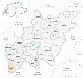
| Location of the municipality | |
Vufflens-la-Ville is a municipality in the Gros-de-Vaud district in the canton of Vaud in Switzerland . The former German name Wolflingen is no longer used today.
geography
Vufflens-la-Ville is 478 m above sea level. M. , 10 km northwest of the canton capital Lausanne (linear distance). The scattered village stretches along the edge of the high plateau of southern Gros de Vaud , above the valley of the Venoge , in the Vaud Plateau .
The area of the 5.3 km² municipal area covers a section of the gently undulating high plateau of the Gros de Vaud, the granary of the canton of Vaud. The eastern part of the municipality is occupied by this plateau, which is on the slope below Sullens at 498 m above sea level. M. reached the highest point of Vufflens-la-Ville. In the south the area extends over the height of the Vimont ( 488 m above sea level ) to the valley section of the Vaube stream . In the west, Vufflens-la-Ville encompasses the wide valley low on the lower reaches of the Venoge, the border mostly not running along the river, but on the western edge of the valley. In 1997, 13% of the municipal area was in settlements, 22% in forests and woodland, 64% in agriculture and a little more than 1% was unproductive land.
Vufflens-la-Ville includes the hamlets of Marteley ( 478 m above sea level ) northeast of the village, La Pale ( 406 m above sea level ) on the Venoge, extensive new housing developments on the eastern slope of the Venoge below the village and an industrial area in Venogetal. The neighboring communities of Vufflens-la-Ville are Penthaz in the north, Sullens in the north-east, Mex in the south-east, Villars-Sainte-Croix in the south-east, Bussigny in the south, Aclens in the south-west and Gollion in the north-west .
population
With 1299 inhabitants (as of December 31, 2018), Vufflens-la-Ville is one of the medium-sized municipalities in the canton of Vaud. 90.1% of the residents are French-speaking, 5.2% German-speaking and 1.7% Italian-speaking (as of 2000). The population of Vufflens-la-Ville was 324 in 1900. Since 1960 (342 inhabitants) a rapid increase in population with a tripling of the number of inhabitants within 40 years has been observed.
| Population development | ||||||||
|---|---|---|---|---|---|---|---|---|
| year | 1980 | 1992 | 1997 | 2000 | 2003 | 2006 | 2009 | 2011 |
| Residents | 747 | 1015 | 1025 | 996 | 1032 | 1070 | 1127 | 1164 |
economy
Vufflens-la-Ville was a predominantly agricultural village until the second half of the 20th century . There was still a smaller wine-growing region until the 1950s . Today arable farming and fruit growing only play a subordinate role in the income structure of the population.
A commercial and industrial zone was created in the Venoge valley since the 1960s. Companies in the electronics and construction industries have settled here, as well as a company that produces heat pumps. In the last few decades the village has developed into a residential community thanks to its attractive location. Many workers are therefore commuters who work mainly in the greater Lausanne area .
traffic
Although the community is off the main thoroughfares, it is still well developed in terms of transport. The motorway connections Cossonay and Lausanne-Crissier on the A1 (Lausanne-Yverdon) are each around 5 km from the town center. On May 7, 1855, the section was Yverdon - Belmont-sur-Lausanne the railway line Yverdon-Lausanne taken with the station Vufflens-la-Ville in Venogetal in operation.
history
Hardly any remains have been discovered from Roman times , when the road from Lausanne to Orbe ran through the municipality. The place was first mentioned in a document in 1002 under the name Vuolflinges . Later the names Villare Wolferii (1094), Volflens (1109), Vulflens (1154), Wofflens li vila (1228), Wolflens la vila (1233) and Voufflens la ville (1454) appeared. The place name goes back to the Burgundian personal name Wulfilo and means for the people of Wulfilo .
The Romainmôtier Abbey had owned rich estates in Vufflens-la-Ville since the 11th century . In the 14th century the village came under the rule of Cossonay. With the conquest of Vaud by Bern in 1536, Vufflens-la-Ville came under the administration of the Bailiwick of Lausanne . After the collapse of the Ancien Régime , the village belonged to the canton of Léman from 1798 to 1803 during the Helvetic Republic, which then became part of the canton of Vaud when the mediation constitution came into force . In 1798 it was assigned to the Cossonay district.
Attractions
The core of the reformed Saint-Etienne church goes back to a Romanesque building from the 11th century. In the 15th century the church was redesigned and in 1777 its orientation was changed by 180 °. In the place of the previous choir (in the east) there is now the portal and the nave, the new choir is in the west; a church tower was also added. In the old town center there are some farmhouses from the 18th and 19th centuries.
Web links
- Official website of the municipality of Vufflens-la-Ville (French)
- François Béboux: Vufflens-la-Ville. In: Historical Lexicon of Switzerland .
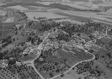
- Aerial photography
Individual evidence
- ↑ Permanent and non-permanent resident population by year, canton, district, municipality, population type and gender (permanent resident population). In: bfs. admin.ch . Federal Statistical Office (FSO), August 31, 2019, accessed on December 22, 2019 .


