
Bioley-Orjulaz
| Bioley-Orjulaz | |
|---|---|
 |
|
| State : |
|
| Canton : |
|
| District : | Gros-de-Vaud |
| BFS no. : | 5513 |
| Postal code : | 1042 |
| Coordinates : | 535 597 / 163665 |
| Height : | 603 m above sea level M. |
| Height range : | 576–620 m above sea level M. |
| Area : | 3.12 km² |
| Residents: | 512 (December 31, 2018) |
| Population density : | 164 inhabitants per km² |
 Bioley-Orjulaz |
|
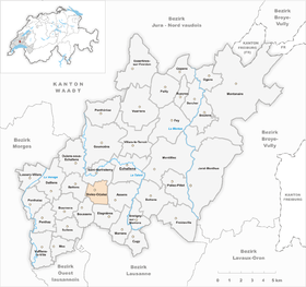
| Location of the municipality | |
  |
|
Bioley-Orjulaz is a municipality in the Gros-de-Vaud district in the canton of Vaud in Switzerland . The addition of the name Orjulaz serves to distinguish it from the municipality of Bioley-Magnoux .
geography
Bioley-Orjulaz lies at 603 m above sea level. M. , 3.5 km southwest of Echallens and 11 km north of the canton capital of Lausanne (as the crow flies). The farming village extends at the eastern foot of a hill on the high plateau des Gros de Vaud , in the Vaudois Central Plateau .
The area of the 3.1 km² municipal area includes a section of the gently undulating high plateau of the Gros de Vaud, the granary of the canton of Vaud. In the western part of the municipality is the hill of Bioley-Orjulaz, on which 621 m above sea level. M. the highest point of the municipality is reached. To the east, the municipality extends into a wide valley , through which the Mortigue stream , a tributary of the Talent , flows in the north . In the far north, the area extends to the slight elevation of Mont Ticino (up to 604 m above sea level ). The southern part of the municipality is occupied by the Bois d'Orjulaz forest . In 1997, 10% of the municipal area was in settlements, 18% in forests and woodlands, 71% in agriculture and around 1% was unproductive land.
Bioley-Orjulaz includes a new residential area on the southern slope of the village hill and an industrial park west of the village hill on the edge of the gravel pit. The neighboring villages of Bioley-Orjulaz are in the north of Saint-Barthélemy , in the east Assens , in the south Etagnières , southwest Boussens and west Bettens .
population
With 512 inhabitants (as of December 31, 2018), Bioley-Orjulaz is one of the small communities in the canton of Vaud. 93.1% of the residents are French-speaking, 2.4% German-speaking and 1.4% Spanish-speaking (as of 2000). The population of Bioley-Orjulaz was 245 inhabitants in 1850 and 220 inhabitants in 1900. A significant increase in population has been observed since 1980 (181 inhabitants).
economy
Bioley-Orjulaz was a predominantly agricultural village until the 20th century . Today arable farming and fruit growing only play a subordinate role in the income structure of the population. To the west of the village there is a large gravel pit that has been exploited since the 19th century. Since the 1970s, new companies have settled in town, including companies in the transport and construction industries, wood processing and a company that specializes in the herb trade. In the last few decades the village has also developed into a residential community. Many workers are therefore commuters who work mainly in the greater Lausanne area .
traffic
The community is well developed in terms of traffic, although it is away from major thoroughfares. The motorway connections Cossonay and La Sarraz on the A1 (Lausanne-Yverdon) opened in 1981 are each around 5 km from the village. The Postbus course, which runs from Echallens to Chavornay , connects Bioley-Orjulaz to the public transport network.
history
The first written mention of the place took place in 1192 under the name Oriola , derived from the Latin word aureolus (golden). Later the names Biolley orjeux (1516) and Bioley-Orjioulaz (1527) appeared. Bioley comes from the French word boulaie (birch grove).
Since the Middle Ages , the village has belonged to the lords of Echallens, who gave the Orjulaz forest to the Lac de Joux ( L'Abbaye ) abbey for use. After the Burgundian Wars , the village came to the Orbe-Echallens Bailiwick in 1476, which was under the common rule of Bern and Friborg . After the collapse of the Ancien Régime , Bioley-Orjulaz belonged to the canton of Léman from 1798 to 1803 during the Helvetic Republic, which then became part of the canton of Vaud when the mediation constitution came into force . In 1798 it was assigned to the Echallens district.
Attractions
The village belongs to the parish of Assens. There has been a reformed church in Bioley-Orjulaz since 1903. In the town center there are some typical farmhouses from the 18th and 19th centuries. Several granaries are noteworthy, including a stone granary with a Renaissance window from 1720 and a wooden granary from the 17th century.
Web links
- Community information
- Marianne Stubenvoll: Bioley-Orjulaz. In: Historical Lexicon of Switzerland .
- Aerial photography
Individual evidence
- ↑ Permanent and non-permanent resident population by year, canton, district, municipality, population type and gender (permanent resident population). In: bfs. admin.ch . Federal Statistical Office (FSO), August 31, 2019, accessed on December 22, 2019 .
Assens | Bercher | Bettens | Bioley-Orjulaz | Bottens | Boulens | Bournens | Boussens | Bretigny-sur-Morrens | Cugy | Daillens | Echallens | Essertines-sur-Yverdon | Etagnières | Fey | Froideville | Goumoëns | Jorat-Menthue | Lussery-Villars | Mex | Montanaire | Morrens | Montilliez | Ogens | Oppens | Oulens-sous-Echallens | Pailly | Penthalaz | Penthaz | Penthéréaz | Poliez-Pittet | Rueyres | Saint Barthélemy | Sullens | Villars-le-Terroir | Vuarrens | Vufflens-la-Ville
Former municipalities: Chapelle-sur-Moudon | Correvon | Denezy | Dommartin | Eclagnens | Goumoens-la-Ville | Goumoens-le-Jux | Lussery | Malapalud | Martherenges | Montaubion Chardonney | Naz | Neyruz-sur-Moudon | Peney-le-Jorat | Peyres-Possens | Poliez-le-Grand | Saint-Cierges | Sottens | Sugnens | Thierrens | Villars-Lussery | Villars-Mendraz | Villars-Tiercelin
Canton of Vaud | Districts of the canton of Vaud | Municipalities of the canton of Vaud