
La Sarraz
| La Sarraz | |
|---|---|
 |
|
| State : |
|
| Canton : |
|
| District : | Morges |
| BFS no. : | 5498 |
| Postal code : | 1315 |
| Coordinates : | 529243 / 167998 |
| Height : | 490 m above sea level M. |
| Height range : | 453–634 m above sea level M. |
| Area : | 7.70 km² |
| Residents: | 2595 (December 31, 2018) |
| Population density : | 337 inhabitants per km² |
| Website: | www.lasarraz.ch |
 La Sarraz |
|
| Location of the municipality | |
  |
|
La Sarraz is a municipality in the Morges district in the canton of Vaud in Switzerland .
geography
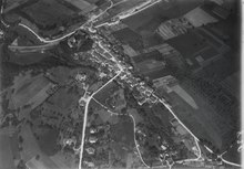
La Sarraz is 490 m above sea level. M. , 17 km north of the district capital Morges (linear distance). The historic town extends on a promontory west of the Mormont , on the northern edge of the Venoge , on the watershed between the catchment areas of the Rhone and Rhine , in the Vaud Central Plateau .
The area of the 7.8 km² municipal area covers a section of the Waadtländer Mittelland. The central part of the area is traversed from west to east by the Venoge, which at La Sarraz emerges from the narrow valley in the Jura foot plateau into a valley plain up to 1 km wide. To the south of this valley, the communal soil extends to the adjacent high plateau of Dizy (on the hill La Crête 601 m above sea level ), with the course of the river Veyron forming the western limit. To the north of the Venoge valley, the area of La Sarraz extends to the height of the Mormont (up to 605 m above sea level ), a rock that separates the Orbe plain in the north (in the Rhine catchment area) from the Venoge in the south (in the Rhone). The commune of La Sarraz extends in a narrow strip to the northwest over a wooded part of the limestone plateau on the Jura foot ( Châtillon , 623 m above sea level ), into which the valley of the Nozon and its small side valley, Vallée d'Engens , are deepened like a gorge . The highest point of La Sarraz is 630 m above sea level. M. reached in the forest area on the lower Jura slope . In 1997, 11% of the municipal area was in settlements, 39% in forests and woodlands, 49% in agriculture and a little less than 1% was unproductive land.
La Sarraz includes the Bois de Fey farm estate ( 555 m above sea level ) on the plateau north of Dizy above the Veyron valley and some individual farms. Neighboring municipalities to La Sarraz are Pompaples , Orny , Eclépens , Lussery-Villars , Dizy , Chevilly , Ferreyres , Romainmôtier-Envy , Croy and Arnex-sur-Orbe .
population
With 2595 inhabitants (as of December 31, 2018), La Sarraz is one of the medium-sized communities in the canton of Vaud. 84.6% of the residents are French-speaking, 4.6% German-speaking, 4.1% Albanian-speaking and 3.7% Portuguese-speaking (as of 2000). The population of La Sarraz was 930 in 1900. After a continuous slight increase in the number of inhabitants, an increased population increase has been observed, especially since 1980 (1210 inhabitants).
economy
Up until the beginning of the 20th century, La Sarraz was a town dominated by agriculture. Today arable farming and fruit growing only play a subordinate role in the income structure of the population. There is a small wine-growing region on the southern slopes of the Mormont . Forestry also plays a certain role.
The town of La Sarraz has been a regional center for trade, handicrafts and small industry since the 19th century. The economic boom began with the opening of the Cossonay-Vallorbe railway. Important operations at this time were a tannery (founded in 1781), a blanket factory and the Freydon mechanical workshops founded in 1858. All of these companies were shut down during the economic downturn in the 1970s.
Today La Sarraz is home to numerous small businesses, Pneumatex SA and Holcim Granulats et Béton SA, which operates a quarry, as well as wood processing, construction and construction machinery companies.
La Sarraz also has various cultural facilities (a local museum and a theater), sports facilities, a swimming pool and a campsite.
traffic
The community has good transport connections. It is on the main road 9 from Lausanne to Vallorbe , a road branches off here to Orbe . The La Sarraz motorway junction on the A1 (Lausanne-Yverdon) opened in 1981 is around 5 km from the town center.
On July 1, 1870, the Cossonay-Vallorbe railway line went into operation with a station in La Sarraz. The ledge on which the town lies is crossed with a short tunnel. A bus line via Pompaples to the Saint-Loup Hospital and a route to L'Isle provide for the fine distribution of public transport .
history


From the Roman period , was crossed as the municipal area of the road from Lausanne to Orbe, remains are hardly obtained. The local history of La Sarraz begins in 1049, when the Lords of Grandson extended their territory to the southwest and built a fortified checkpoint on the rocky promontory west of the Mormont on an important trade and pilgrimage route. With this the traffic from France over the pass Col de Jougne through the Vaud Central Plateau and over the Great Saint Bernard to Italy was controlled.
The first written mention of the place took place in 1158 under the name Sarata . Later the names Sarrata (1186), La Sarrée (1227), La Sara (1235) and cellam de Serra (1286) appeared. For a long time the place name was La Sarra , the z has only recently been added. The place name is derived from the past participle serata (used in Latin as well as in patois ) in the meaning of included and attached .
In the late 11th century, a settlement developed around the fortification tower. This was fortified in the 12th century and provided with a wall and gates. The lords of the castle, a side branch of the lords of Grandson , established the La Sarraz manor at that time, which was one of the most important in the Vaud region. The estate was owned by the Grandson-La Sarra family from 1049 to 1269, the Montferrand-La Sarra family from 1269 to 1541, the Gingins-La Sarra family from 1541 to 1798 and their descendants until 1948.
The town received extensive freedom in 1345 and experienced an economic boom through trade and craft. From the second half of the 14th century, La Sarraz received the right from the Dukes of Savoy to hold four annual fairs; In 1597 the weekly market was introduced.
With the conquest of Vaud by Bern in 1536, La Sarraz came under the administration of the Bailiwick of Romainmôtier . After the collapse of the Ancien Régimes , the town belonged to the canton of Léman from 1798 to 1803 during the Helvetic Republic , which then became part of the canton of Vaud when the mediation constitution came into force . In 1798 it was assigned to the Cossonay district.
Attractions

The core of La Sarraz Castle dates back to the 11th century, and was largely rebuilt in the 13th century. During the Burgundian Wars , it was partially destroyed by the Confederates in 1475 and was affected again when the Vaud region was conquered in 1536. The two towers at the castle portal from the medieval building still stand today, the right (lower) tower originally served as a keep. The remaining castle buildings were only built after the Reformation through renovations and new constructions . The former walling was torn down in the 19th century when the palace gardens were laid out. Today the castle houses the local history museum (rich interior decoration from the reign of the La Sarra family) and since 1979 a horse museum in the farm buildings.
From 1360 to 1370 the Saint-Antoine chapel (also called Chapelle Jaquemart) was built. On the one hand it served as a church for the townspeople and on the other hand as a burial place for the noble family. It contains the arkosol tomb of the founder François I de La Sarra (died 1363), which is one of the most beautiful aristocratic tombs in Switzerland. The neo-classical parish church was added to this chapel in the 19th century .
The historic town with two parallel streets has retained its picturesque townscape. The streets are lined with town houses and patrician houses from the 18th and 19th centuries.
The waterfall La Tine de Conflens in a small rock basin at the confluence of the Veyron and Venoge is a natural attraction.
The Canal d'Entreroches is a cultural monument of technology and transport history near La Sarraz.
Personalities
- Claire Krähenbühl , writer and artist
- Ludwig Heinrich Ferdinand Olivier (* 1759 in La Sarraz, † 1815 in Vienna), educator
Web links
- Official website of the municipality of La Sarraz (French)
- Patrick-R. Monbaron: Sarraz, La (parish). In: Historical Lexicon of Switzerland .
- Tourist website for La Sarraz and its region
- Aerial photography
- Château de La Sarraz
Individual evidence
- ↑ Permanent and non-permanent resident population by year, canton, district, municipality, population type and gender (permanent resident population). In: bfs. admin.ch . Federal Statistical Office (FSO), August 31, 2019, accessed on December 22, 2019 .
Aclens | Allaman | Apple's | Aubonne | Bale | Berolle | Bière | Bougy-Villars | Bremblens | Buchillon | Bussy Chardonney | La Chaux (Cossonay) | Chavannes-le-Veyron | Chevilly | Chigny | Clarmont | Cossonay | Cottens | Cuarnens | Denens | Denges | Dizy | Echandens | Echichens | Eclépens | Etoy | Féchy | Ferreyres | Gimel | Gollion | Grancy | L'Isle | Lavigny | Lonay | Lully | Lussy-sur-Morges | Mauraz | Moiry | Mollens | Montherod | Mont-la-Ville | Montricher | Morges | Orny | Pampigny | Pompaples | Préverenges | Reverolle | Romanel-sur-Morges | Saint-Livres | Saint-Oyens | Saint-Prex | La Sarraz | Saubraz | Senarclens | Sévery | Tolochenaz | Vaux-sur-Morges | Villars-sous-Yens | Vufflens-le-Château | Vullierens | Yens
Former municipalities: Bussy-sur-Morges | Chardonney-sur-Morges | Colombier | Monnaz | Pizy | Saint-Saphorin-sur-Morges
Municipalities that moved to the District de Ouest Lausanne on January 1st, 2008 : Bussigny-près-Lausanne | Chavannes-près-Renens | Ecublens | Saint-Sulpice | Villars-Sainte-Croix
Canton of Vaud | Districts of the canton of Vaud | Municipalities of the canton of Vaud