
Beers
| Beers | |
|---|---|
 |
|
| State : |
|
| Canton : |
|
| District : | Morges |
| BFS no. : | 5425 |
| Postal code : | 1145 |
| Coordinates : | 515254 / 154591 |
| Height : | 698 m above sea level M. |
| Height range : | 565–1608 m above sea level M. |
| Area : | 25.06 km² |
| Residents: | 1590 (December 31, 2018) |
| Population density : | 63 inhabitants per km² |
| Website: | www.biere-vd.ch |
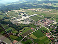
 View of Bière |
|
| Location of the municipality | |
  |
|
Bière is a municipality in the Morges district in the canton of Vaud in Switzerland .
geography
Bière is 698 m above sea level. M. , 13 km west of the district capital Morges (linear distance). The clustered village extends along the Aubonne , at the southern foot of the Jura and on the upstream Jura foot plateau.
The area of the 25.0 km² municipal area includes a section of the Jura foot plateau and the Vaud Jura. The south-eastern part of the municipality is occupied by this plateau, in which the Aubonne and the Toleure had dug deep valleys over the course of millions of years. In the far east the area extends into the Le Sépey forest (up to 725 m above sea level ). To the northwest, the municipality extends over the densely wooded steep slope ( Côte de Bière ) with the source areas of Aubonne and Toleure up to the anticline of the Mont-Tendre chain . The Crêt de Mondisé ( 1525 m above sea level ) lies in front of the Mont Tendre in the southeast , to the west of which there are several small depressions and then the ridge of Monts de Bière ( 1530 m above sea level ) and Cunay , on which 1609 m above sea level . M. the highest point of Bière is reached. The Glacière de Saint-Livres is an ice cave at around 1380 m above sea level. M. on this Jura chain. In the area of Grand Cunay and Pré de Saint-Livres there are extensive Jura high pastures with mighty spruce trees that either stand individually or in groups. In 1997, 6% of the municipal area was in settlements, 52% in forests and trees, 37% in agriculture and around 5% was unproductive land (Bière arsenal).
Numerous individual farms belong to Bière. Neighboring municipalities of Bière are Berolle , Ballens , Yens , Saint-Livres , Montherod , Saubraz , Gimel and Le Chenit .
population
With 1590 inhabitants (as of December 31, 2018), Bière is one of the medium-sized municipalities in the canton of Vaud. 87.4% of the residents are French-speaking, 3.6% German-speaking and 3.6% Portuguese-speaking (as of 2000). The population of Bière was 1181 in 1850 and 1269 in 1900. After the population had decreased slightly to 1166 by 1960, an upward trend has been recorded since then.
economy
Up until the beginning of the 20th century, Bière was a predominantly agricultural village. Agriculture still plays a certain role as a branch of the population. It focuses on agriculture and animal husbandry on the Jura foot plateau as well as on dairy farming and animal husbandry on the heights.
Mills, sawmills, blacksmiths and tanneries have been using the water power of the Aubonne since the 16th century. There was also a brick factory and a paper mill. Thanks to the good transport connections, several construction companies, a ski factory and the cement, concrete and gravel factory Holcim SA have settled in Bière. There are other jobs in the service sector.
Bière is known throughout Switzerland as the location of an artillery and infantry arsenal, the origin of which goes back to 1822, when the federal troops first used the Plateau Sur Champagne, which was bordered by Aubonne and Toleure, for larger training units. The arsenal was created in 1874 for artillery and infantry and came into the possession of the Swiss Confederation in 1913.
traffic
The community has good transport connections. It is on the main road that leads from Aubonne via Bière over the Col du Marchairuz into the Vallée de Joux . On July 1, 1895, the narrow-gauge railway Bière-Apples-Morges was put into operation. Bière is also served by the Gimel – L'Isle bus line.
history
The remains of a fortified Roman camp point to an early settlement of the municipality; In addition, graves from the early Middle Ages were discovered. The first written mention of the place took place in 1177 under the name Beria ; In 1228 the spelling Bieri appeared . The place name is derived from the old French word berrie ( level ). A local noble family has been mentioned since the 12th century. Also in the 12th century, the Canons of the Great Saint Bernard founded a priory in Bière.
With the conquest of Vaud by Bern in 1536, the priory property was converted into a lordship and Bière came under the administration of the Bailiwick of Morges . After the collapse of the Ancien Régime , the village belonged to the canton of Léman from 1798 to 1803 during the Helvetic Republic, which then became part of the canton of Vaud when the mediation constitution came into force . In 1798 it was assigned to the Aubonne district.
Attractions
The Saint-Benoît church dates from the 15th century, but was later restored and redesigned several times. In the choir wall you can see the portal from the 12th century, which once led to the priory, which has now disappeared. In the town center there are some typical farmhouses from the 17th to 19th centuries.

railway station
Military area 2007

Military area and village 1949


Web links
- Official website of the municipality of Bière
- Henri Burnier: Bière. In: Historical Lexicon of Switzerland .
- Aerial photography
Individual evidence
- ↑ Permanent and non-permanent resident population by year, canton, district, municipality, population type and gender (permanent resident population). In: bfs. admin.ch . Federal Statistical Office (FSO), August 31, 2019, accessed on December 22, 2019 .
Aclens | Allaman | Apple's | Aubonne | Bale | Berolle | Bière | Bougy-Villars | Bremblens | Buchillon | Bussy Chardonney | La Chaux (Cossonay) | Chavannes-le-Veyron | Chevilly | Chigny | Clarmont | Cossonay | Cottens | Cuarnens | Denens | Denges | Dizy | Echandens | Echichens | Eclépens | Etoy | Féchy | Ferreyres | Gimel | Gollion | Grancy | L'Isle | Lavigny | Lonay | Lully | Lussy-sur-Morges | Mauraz | Moiry | Mollens | Montherod | Mont-la-Ville | Montricher | Morges | Orny | Pampigny | Pompaples | Préverenges | Reverolle | Romanel-sur-Morges | Saint-Livres | Saint-Oyens | Saint-Prex | La Sarraz | Saubraz | Senarclens | Sévery | Tolochenaz | Vaux-sur-Morges | Villars-sous-Yens | Vufflens-le-Château | Vullierens | Yens
Former municipalities: Bussy-sur-Morges | Chardonney-sur-Morges | Colombier | Monnaz | Pizy | Saint-Saphorin-sur-Morges
Municipalities that moved to the District de Ouest Lausanne on January 1st, 2008 : Bussigny-près-Lausanne | Chavannes-près-Renens | Ecublens | Saint-Sulpice | Villars-Sainte-Croix
Canton of Vaud | Districts of the canton of Vaud | Municipalities of the canton of Vaud