Toleurs
| Toleurs | ||
|
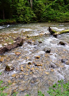
The Toleure just before the confluence with the Aubonne |
||
| Data | ||
| location | Switzerland | |
| River system | Rhône | |
| Drain over | Aubonne → Rhône → Mediterranean | |
| source | west of Bière 46 ° 32 ′ 3 ″ N , 6 ° 18 ′ 47 ″ E |
|
| Source height | 741 m above sea level M. | |
| muzzle | northwest of Aubonne VD in the Aubonne coordinates: 46 ° 31 ′ 8 " N , 6 ° 21 ′ 32" E ; CH1903: 517 136 / 152 521 46 ° 31 '8 " N , 6 ° 21' 32" O |
|
| Mouth height | 572 m above sea level M. | |
| Height difference | 169 m | |
| Bottom slope | 34 ‰ | |
| length | 5 km | |
| Drain |
MQ |
2.84 m³ / s |
The Toleure is a river at the foot of the Jura Mountains in the canton of Vaud in Switzerland .
geography
Source you Toleure
The Toleure rises at the foot of the Mont-Tendre chain near the point where the municipal areas of Bière , Gimel VD and Saubraz meet. The Source du Toleure (Eng. "Source des Toleure") is a karst spring and forms a natural overflow of the nearby Source de l'Aubonne .
If the Aubonne spring rises more than 2130 liters of water per second, the Toleure spring also pours . On the other hand, it dries up with a source discharge below 2090 l / s. The spring is dry for around 40% of the year (134 days in 1999 and 2000). The same applies to the sources of the Malagne stream near Montricher VD . They begin to flow when the flow of the toleure source exceeds 4865 l / s.
course
The Toleure runs after its origin, as a border river between the municipalities of Bière and Saubraz, in a south-easterly direction and after about 4 km of the river takes up the 8 km long Saubrette from the right. Shortly afterwards, the Toleure flows northwest of Aubonne VD as a right tributary into the somewhat shorter and often less arid Aubonne .
Tributaries
- Saubrette (right)
Web links
Individual evidence
- ↑ a b c Geoserver of the Swiss Federal Administration ( information )
