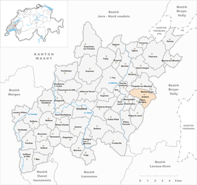
Sottens
| Sottens | ||
|---|---|---|
| State : |
|
|
| Canton : |
|
|
| District : | Gros-de-Vaud | |
| Municipality : | Jorat-Menthue | |
| Postal code : | 1062 | |
| former BFS no. : | 5687 | |
| Coordinates : | 546 672 / 167354 | |
| Height : | 755 m above sea level M. | |
| Area : | 4.53 km² | |
| Residents: | 256 (December 31, 2010) | |
| Population density : | 57 inhabitants per km² | |
| map | ||
|
|
||
Sottens was a municipality in the Gros-de-Vaud district in the canton of Vaud in Switzerland . Sottens merged on July 1, 2011 with the municipalities of Montaubion-Chardonney , Peney-le-Jorat , Villars-Mendraz and Villars-Tiercelin to form the new municipality of Jorat-Menthue .
geography
Sottens is located at 755 m above sea level. M., 17 kilometers northeast of the canton capital of Lausanne (linear distance ). The clustered village extends over a wide plateau north of the Jorat , between the valley cuts of the Mentue in the west and the Mérine in the east, in the Molasse hill country of the northern Vaud Central Plateau .
The area of the 4.5 km² former municipal area comprises a section of the high plateau between the Mentue and the central Broyetal . The main part of the area is occupied by the high plateau, which is slightly subdivided to the west of the village by knolls and hollows (including the former marshland Le Marais ). The highest point of Sottens is on the hill La Crêta at 793 m above sea level. M. achieved. In the far west, above Peyres-Possens, there is a large gravel and sand pit. The Mérine stream, which rises in the municipality, has carved an erosion valley into the molasse layers south of the village over the course of millions of years . The Mérine with its two tributaries Tenette (in the north) and Ruisseau de Neyrevaux (in the south) has divided the eastern municipality into the plateaus of the Trimont (756 m above sea level) and the Bois de Ban (782 m above sea level) . In 1997, 7% of the municipal area was accounted for by settlements, 30% for forests and woodlands and 63% for agriculture.
Several individual farms belonged to the community of Sottens. Neighboring communities of Sottens were Chapelle-sur-Moudon , Martherenges , Moudon , Hermenches , Villars-Mendraz , Montaubion-Chardonney and Peyres-Possens .
population
With 256 inhabitants (as of December 31, 2010), Sottens was one of the small communities in the canton of Vaud. 85.7% of the residents are French-speaking, 7.1% German-speaking and 5.7% Portuguese-speaking (as of 2000). The population of Sottens was 195 inhabitants in 1900. After that, a decrease to 153 inhabitants was recorded by 1970; since then the population has increased significantly again.
economy
Until the middle of the 20th century, Sottens was a predominantly agricultural village. Even today, arable farming , fruit growing and animal husbandry have a certain importance in the income structure of the population. Further jobs are available in local small businesses and in the service sector. With the construction of new single-family houses in recent decades, the village has also developed into a residential community. Some workers are therefore commuters who work in the surrounding larger towns.
Country broadcaster
Sottens has become known as the location of the Sottens national broadcaster for French-speaking Switzerland, which began operations in 1931. This transmitter was operated on the medium wave frequency 765 kHz with an output of 600 kilowatts and could be heard during the night in large parts of Europe. Since 1989, a cage antenna with central feed attached to a 188 meter high, free-standing, grounded steel lattice tower was used as the transmitting antenna. Before 1989, a 190 meter high self-radiating steel lattice tower was in use as a transmitting antenna. Receiving Reports were from the station, the last program Option Musique of Radio Suisse Romande , confirmed radiates. The transmitter ceased operations on January 1, 2011 at 00:00.
See also: Landessender Beromünster , Landessender Monte Ceneri , Savièse
traffic
Sottens is located off the main thoroughfares on a connecting road from Echallens to Moudon . Sottens is connected to the public transport network by the buses that run from Moudon via Villars-Mendraz to Thierrens and from Thierrens to Froideville .
history
The first written mention of the place took place in 1147 under the name Sotens . Later the names Sothens (1161), Setens also appeared in the 12th century and Soutens (1453). The place name is derived from the Burgundian personal name Sota , a popular short name for Sauthaharius , and means for the people of Sota .
Since the 14th century, Sottens was under the influence of the Dukes of Savoy . With the conquest of Vaud by Bern in 1536, the village came under the administration of the Moudon Bailiwick . After the collapse of the Ancien Régime , Sottens belonged to the canton of Léman from 1798 to 1803 during the Helvetic Republic , which then became part of the canton of Vaud when the mediation constitution came into force . In 1798 it was assigned to the Moudon district. Sottens does not have its own church, it belongs to the parish of Chapelle-sur-Moudon .


