
Sullens
| Sullens | |
|---|---|
 |
|
| State : |
|
| Canton : |
|
| District : | Gros-de-Vaud |
| BFS no. : | 5501 |
| Postal code : | 1036 |
| Coordinates : | 533 116 / 160604 |
| Height : | 591 m above sea level M. |
| Height range : | 488–610 m above sea level M. |
| Area : | 3.91 km² |
| Residents: | 1036 (December 31, 2018) |
| Population density : | 265 inhabitants per km² |
| Website: | www.sullens.ch |
 Sullens |
|
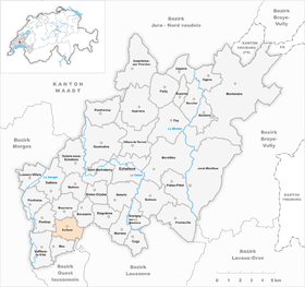
| Location of the municipality | |
  |
|
Sullens is a municipality in the Gros-de-Vaud district in the canton of Vaud in Switzerland .
geography
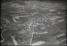
Sullens lies at 591 m above sea level. M. , 10 km north-north-west of the canton capital Lausanne (air line). The clustered village extends on the high plateau of the southern Gros de Vaud , east of the Venoge valley , in the Vaud Central Plateau .
The 3.8 km² municipal area covers a section of the gently undulating high plateau of the Gros de Vaud, the granary of the canton of Vaud. The municipality extends from the valley low of an eastern side stream of the Venoge to the east on the wide plateau of Sullens, on which at 605 m above sea level. M. the highest point of the municipality is reached. In the southeast, the area extends into the Bois du Dévin forest in the headwaters of the Chamberonne and in the south into the Bois Bahud . In 1997, 15% of the municipal area was accounted for by settlements, 13% for forests and woodlands and 72% for agriculture.
Two larger new housing estates belong to Sullens. The neighboring communities of Sullens are in the south Mex , in the southwest of Vufflens-la-Ville , in the northwest Penthaz , in the north Bournens , northeast Boussens , in the southeast of Cheseaux-sur-Lausanne and in the south-southeast Crissier .
population
With 1,036 inhabitants (as of December 31, 2018), Sullens is one of the smaller municipalities in the canton of Vaud. 87.2% of the residents are French-speaking, 7.5% German-speaking and 1.2% Italian-speaking (as of 2000). The population of Sullens was 317 in 1900. After the population had decreased to 253 by 1960, a clear increase in population was observed again, with the number of inhabitants tripling within 40 years.
economy
Until the second half of the 20th century, Sullens was a predominantly agricultural village. Today arable farming and fruit growing only play a subordinate role in the income structure of the population. Further jobs are available in small businesses and in the service sector (including an IT company). In the last few decades the village has developed into a residential community thanks to its attractive location. Many workers are therefore commuters who work mainly in the greater Lausanne area .
traffic
The community is very well developed in terms of transport. It is located on the main road from Cossonay to Cheseaux-sur-Lausanne . The Cossonay motorway junction on the A1 (Lausanne-Yverdon) opened in 1981 is only around 1 km from the town center. Sullens is connected to the public transport network through a Postbus course that runs from Cossonay to Cheseaux-sur-Lausanne.
history
The first written mention of the place took place in 1180 under the name Sollens . Later the names Soulens (1228), today's name Sullens (1287) and Sulens (1387) appeared. The place name goes back to the Burgundian personal name Saudila and means for the people of Saudila .
Sullens was part of the Cossonay rule since the Middle Ages . In 1180, the Saint-Maurice Abbey received rich property, which was transferred to the Haut-Crêt Abbey in the 13th century . With the conquest of Vaud by Bern in 1536, Sullens came under the administration of the Bailiwick of Morges . After the collapse of the Ancien Régime , the village belonged to the canton of Léman from 1798 to 1803 during the Helvetic Republic, which then became part of the canton of Vaud when the mediation constitution came into force . In 1798 it was assigned to the Cossonay district.
Attractions
The parish church of Sullens was rebuilt in 1712/13; the attic served as a granary in earlier times. In the compact old town center, some characteristic farmhouses from the 17th to 19th centuries have been preserved.
Web links
- Official website of the municipality of Sullens (French)
- Marianne Stubenvoll: Sullens. In: Historical Lexicon of Switzerland .
- Aerial photography
Individual evidence
- ↑ Permanent and non-permanent resident population by year, canton, district, municipality, population type and gender (permanent resident population). In: bfs. admin.ch . Federal Statistical Office (FSO), August 31, 2019, accessed on December 22, 2019 .
Assens | Bercher | Bettens | Bioley-Orjulaz | Bottens | Boulens | Bournens | Boussens | Bretigny-sur-Morrens | Cugy | Daillens | Echallens | Essertines-sur-Yverdon | Etagnières | Fey | Froideville | Goumoëns | Jorat-Menthue | Lussery-Villars | Mex | Montanaire | Morrens | Montilliez | Ogens | Oppens | Oulens-sous-Echallens | Pailly | Penthalaz | Penthaz | Penthéréaz | Poliez-Pittet | Rueyres | Saint Barthélemy | Sullens | Villars-le-Terroir | Vuarrens | Vufflens-la-Ville
Former municipalities: Chapelle-sur-Moudon | Correvon | Denezy | Dommartin | Eclagnens | Goumoens-la-Ville | Goumoens-le-Jux | Lussery | Malapalud | Martherenges | Montaubion Chardonney | Naz | Neyruz-sur-Moudon | Peney-le-Jorat | Peyres-Possens | Poliez-le-Grand | Saint-Cierges | Sottens | Sugnens | Thierrens | Villars-Lussery | Villars-Mendraz | Villars-Tiercelin
Canton of Vaud | Districts of the canton of Vaud | Municipalities of the canton of Vaud