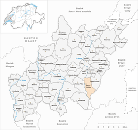
Villars-Tiercelin
| Villars-Tiercelin | ||
|---|---|---|
| State : |
|
|
| Canton : |
|
|
| District : | Gros-de-Vaud | |
| Municipality : | Jorat-Menthue | |
| Postal code : | 1058 | |
| former BFS no. : | 5538 | |
| Coordinates : | 543751 / 164 262 | |
| Height : | 813 m above sea level M. | |
| Area : | 5.02 km² | |
| Residents: | 408 (December 31, 2010) | |
| Population density : | 81 inhabitants per km² | |
| Website: | www.villars-tiercelin.ch | |
| map | ||
|
|
||
Villars-Tiercelin was a municipality in the Gros-de-Vaud district in the canton of Vaud in Switzerland . On July 1, 2011, Villars-Tiercelin merged with the municipalities of Montaubion-Chardonney , Peney-le-Jorat , Sottens and Villars-Mendraz to form the new municipality of Jorat-Menthue .
geography
Villars-Tiercelin is 813 m above sea level. M. , six kilometers east- south -east of Echallens and 13 km north-northeast of the canton capital Lausanne (linear distance ). The farming village extends to the north of the heights of the Jorat , east of the Mentue valley , in the Vaud Central Plateau .
The area of the 5.0 km² former municipality covers a section of the higher Vaud Central Plateau. The western border ran along the upper course of the Mentue, which was slightly sunk into the molasse layers . To the east, the municipality extends over the slope of Villars-Tiercelin to the ridge that separates the catchment area of the Mentue from that of the Broye . The border ran over the forest heights of Le Faz ( 885 m above sea level ) and Le Mottex (at 912 m above sea level, the highest point in Villars-Tiercelin). In the far south, the former municipal area extends into the wooded headwaters of the Mentue with the La Corbassière and Ruisseau de la Rosse streams . The clearing island of Chalet du Villars is located here . In 1997, 6% of the municipal area was accounted for by settlements, 48% for forests and woodlands and 46% for agriculture.
A few individual farms belonged to the municipality of Villars-Tiercelin. Neighboring communities to Villars-Tiercelin were Froideville , Poliez-Pittet , Dommartin , Montaubion-Chardonney , Peney-le-Jorat and Corcelles-le-Jorat .
population
With 408 inhabitants (as of December 31, 2010), Villars-Tiercelin was one of the small communities in the canton of Vaud. 93.6% of the residents are French-speaking, 3.5% German-speaking and 0.9% English-speaking (as of 2000). The population of Villars-Tiercelin was 248 in 1900. After the population had decreased to 152 people by 1970, a significant increase in population was recorded again with a doubling of the population within 30 years.
economy
Until the second half of the 20th century, Villars-Tiercelin was predominantly an agricultural village. Even today, agriculture , animal husbandry and forestry have a certain importance in the income structure of the population. Further jobs are available in local small businesses and in the service sector. In the last few decades the village has also developed into a residential community. Many workers are therefore commuters who work in Echallens and the greater Lausanne area .
traffic
Villars-Tiercelin is away from major thoroughfares, but has good connections with the neighboring villages. Villars-Tiercelin is connected to the public transport network by a postbus course that runs from Echallens to Thierrens . Another bus line connects with Froideville .
history
The first written mention of the place took place in 1225 under the names Vilar Tiecelin and Vilar Tiezelin . In 1668 the name Villar Thiercelin appeared . Since the Middle Ages, Villars-Tiercelin has been under the Lausanne cathedral chapter. With the conquest of Vaud by Bern in 1536, the village came under the administration of Kastlanei Dommartin, which was an exclave of the Bailiwick of Lausanne . After the collapse of the Ancien Régime , Villars-Tiercelin belonged to the canton of Léman from 1798 to 1803 during the Helvetic Republic, which then became part of the canton of Vaud when the mediation constitution came into force . In 1798 it was assigned to the Echallens district.
Attractions
A church in Villars-Tiercelin has been mentioned since 1225. The current building was built in 1795 based on the church of Dommartin . Some stately farmhouses from the 18th and 19th centuries have been preserved in the town center.
Web links
- Marianne Stubenvoll: Villars-Tiercelin. In: Historical Lexicon of Switzerland .
- Aerial photography


