
Boussens VD
| VD is the abbreviation for the canton of Vaud in Switzerland and is used to avoid confusion with other entries of the name Boussens . |
| Boussens | |
|---|---|
 |
|
| State : |
|
| Canton : |
|
| District : | Gros-de-Vaud |
| BFS no. : | 5473 |
| Postal code : | 1034 |
| UN / LOCODE : | CH BSS |
| Coordinates : | 534 405 / 161701 |
| Height : | 594 m above sea level M. |
| Height range : | 586–612 m above sea level M. |
| Area : | 3.16 km² |
| Residents: | 969 (December 31, 2018) |
| Population density : | 307 inhabitants per km² |
| Website: | www.boussens.ch |
 Boussens |
|
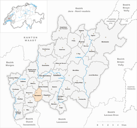
| Location of the municipality | |
  |
|
Boussens ([ busɑ̃ ], Franco-Provençal [ buˈsɛː ]) is a municipality in the Gros-de-Vaud district in the canton of Vaud in Switzerland .
geography
Boussens is located at 594 m above sea level. M. , 11 km north-north-west of the canton capital Lausanne (linear distance). The village extends on the plateau in the Gros de Vaud , in the Swiss Central Plateau , east of the Venoge valley .
The area of the 3.1 km² municipal area comprises a section of the gently undulating plateau of the Gros de Vaud, the granary of the canton of Vaud. Most of the community land is taken up by the plain east of the village. To the east, the area extends into the Bois Lovet forest with the Grand-Marais marshland , where peat used to be cut, and to the north is the Lac Coffy wetland . The southern border runs along the Bois du Dévin forest , the headwaters of the Chamberonne . The highest point of Boussens is 613 m above sea level. M. on the hill west of the village. In 1997, 6% of the municipal area was accounted for by settlements, 14% for forests and woodlands and 80% for agriculture.
Boussens includes the hamlets of Chevrine ( 604 m above sea level ) north of the village and Grange aux Aguet ( 587 m above sea level ) on the plain. The neighboring municipalities of Boussens are in the southwest of Sullens , in the west of Bournen , in the north of Bettens , in the northeast of Bioley-Orjulaz , in the east of Etagnières and in the south of Cheseaux-sur-Lausanne .
population
With 969 inhabitants (as of December 31, 2018), Boussens is one of the smaller municipalities in the canton of Vaud. 93.1% of the residents are French-speaking, 3.1% German-speaking and 1.2% English-speaking (as of 2000). The population of Boussens was 158 inhabitants in 1850 and 147 inhabitants in 1900. After 1960 (137 inhabitants) a rapid increase in population began with a fivefold increase in the number of inhabitants within 40 years.
economy
Until the second half of the 20th century, Boussens was a predominantly agricultural village. Even today arable farming has a certain importance in the employment structure of the population. Further jobs are available in local small businesses and especially in the service sector (mechanical engineering, IT, wine trade). In the last few decades the village has developed into a residential community. New residential quarters emerged on the southern edge of the village and between Boussens and Chevrine. Many workers are therefore commuters who work mainly in the greater Lausanne area.
traffic
The community has good transport connections. It is located on a main road from Lausanne via Cheseaux-sur-Lausanne to Orbe . The Cossonay motorway junction on the A1 (Lausanne-Yverdon) opened in 1981 is around 3 km from the town. The Postbus course, which runs from Cossonay to Cheseaux-sur-Lausanne, connects Boussens to the public transport network.
history
The place was first mentioned in 1177 under the name Bussens , and in 1223 the name Bossens appeared . The place name goes back to the Burgundian personal name Busso and means for the people of Busso . In the Middle Ages, Boussens was under the rule of Cossonay . The area around Grange aux Aguets belonged to the Cistercian Abbey of Montheron .
With the conquest of Vaud by Bern in 1536, Boussens came under the administration of the Bailiwick of Morges . After the collapse of the Ancien Régime , the village belonged to the canton of Léman from 1798 to 1803 during the Helvetic Republic, which then became part of the canton of Vaud when the mediation constitution came into force . In 1798 Boussens was first assigned to the Echallens district, in 1803 it came to the Cossonay district.
Attractions
The manor house of Boussens was built in 1670 by the de Saussure family, who ruled the village from 1581 to 1798.
Web links
- Official website of the municipality of Boussens (French)
- François Béboux: Boussens. In: Historical Lexicon of Switzerland .
- Aerial photography
Individual evidence
- ↑ Permanent and non-permanent resident population by year, canton, district, municipality, population type and gender (permanent resident population). In: bfs. admin.ch . Federal Statistical Office (FSO), August 31, 2019, accessed on December 22, 2019 .
- ↑ Nicolas Pépin, Boussens VD (Cossonay) in: Dictionnaire toponymique des communes suisses - Lexicon of Swiss community names - Dizionario toponomastico dei comuni svizzeri (DTS | LSG) , Center de dialectologie, Université de Neuchâtel, Verlag Huber, Frauenfeld / Stuttgart / Vienna 2005 , ISBN 3-7193-1308-5 and Éditions Payot, Lausanne 2005, ISBN 2-601-03336-3 , p. 179.
Assens | Bercher | Bettens | Bioley-Orjulaz | Bottens | Boulens | Bournens | Boussens | Bretigny-sur-Morrens | Cugy | Daillens | Echallens | Essertines-sur-Yverdon | Etagnières | Fey | Froideville | Goumoëns | Jorat-Menthue | Lussery-Villars | Mex | Montanaire | Morrens | Montilliez | Ogens | Oppens | Oulens-sous-Echallens | Pailly | Penthalaz | Penthaz | Penthéréaz | Poliez-Pittet | Rueyres | Saint Barthélemy | Sullens | Villars-le-Terroir | Vuarrens | Vufflens-la-Ville
Former municipalities: Chapelle-sur-Moudon | Correvon | Denezy | Dommartin | Eclagnens | Goumoens-la-Ville | Goumoens-le-Jux | Lussery | Malapalud | Martherenges | Montaubion Chardonney | Naz | Neyruz-sur-Moudon | Peney-le-Jorat | Peyres-Possens | Poliez-le-Grand | Saint-Cierges | Sottens | Sugnens | Thierrens | Villars-Lussery | Villars-Mendraz | Villars-Tiercelin
Canton of Vaud | Districts of the canton of Vaud | Municipalities of the canton of Vaud