
Bercher
| Bercher | |
|---|---|
 |
|
| State : |
|
| Canton : |
|
| District : | Gros-de-Vaud |
| BFS no. : | 5512 |
| Postal code : | 1038 |
| Coordinates : | 543 806 / 171462 |
| Height : | 637 m above sea level M. |
| Height range : | 529–669 m above sea level M. |
| Area : | 4.27 km² |
| Residents: | 1238 (December 31, 2018) |
| Population density : | 290 inhabitants per km² |
| Website: | www.bercher-vd.ch |
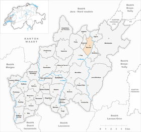
| Location of the municipality | |
  |
|
Bercher is a municipality in the Gros-de-Vaud district in the canton of Vaud in Switzerland .
geography

Bercher is at 637 m above sea level. M. , 20 km north of the canton capital Lausanne (linear distance). The clustered village extends on the high plateau of the northeast Gros de Vaud , west of the deeply cut valley of the Mentue , in the Vaudois Central Plateau .
The area of the 4.3 km² municipal area includes a section of the Gros de Vaud, the granary of the canton of Vaud. Most of the communal soil is taken up by the Bercher plateau, which is just over 1 km wide and is located in the south on the hill La Chavanne at 668 m above sea level. M. reaches the highest point. The plateau is bounded in the east by the wooded valley of the middle Mentue, cut into the molasse layers , about 100 m deep , while the western border runs along the brook Foirause . In the far south the area extends into the forest of Béta . In 1997, 14% of the municipal area was accounted for by settlements, 26% for forests and woodlands and 60% for agriculture.
Bercher includes the Le Martinet settlement ( 559 m above sea level ) on the Mentue below the village, as well as some individual farms. The neighboring communities of Bercher are Fey in the south-west, Rueyres in the west , Oppen in the north, Ogens in the north-east, Montanaire in the east and Boulens in the south-east .
population

With 1238 inhabitants (as of December 31, 2018) Bercher is one of the smaller municipalities in the canton of Vaud. 92.1% of the residents are French-speaking, 3.4% German-speaking and 1.4% Portuguese-speaking (as of 2000). The population of Bercher was 329 in 1850 and 524 in 1900. After the population had decreased to 407 by 1960, a rapid population increase with a doubling of the population within 40 years was observed.
economy
Up until the beginning of the 20th century, Bercher was a predominantly agricultural village. Today arable farming , fruit growing and cattle breeding are only of secondary importance in the income structure of the population.
There is evidence of a mill on the Mentue since the 14th century; there was a forge at Le Martinet. A significant economic boom followed in 1880 with the establishment of the condensed milk factory by Nestlé , which was in operation until 1921. This made Bercher a regional center for trade and commerce. Today the village has transport, horticultural, mechanical workshops, a central grain warehouse and numerous smaller businesses. Bercher is the seat of an agricultural cooperative.
In the last few decades the village has also developed into a residential community. Many workers are therefore commuters who work mainly in the greater Lausanne area and in Yverdon.
traffic
The community is very well developed in terms of traffic. It is located on a connecting road from Echallens towards Payerne . On November 24, 1898, the Echallens-Bercher section of the Chemin de fer Lausanne-Echallens-Bercher (LEB) narrow-gauge railway was put into operation. The reason for the extension of the railway line from Echallens to Bercher was the development boost brought about by the condensed milk factory. From the terminus in Bercher there are buses to Yverdon-les-Bains and Thierrens .
history

The earliest traces on the municipality of Bercher come from Roman times . The first written mention of the place took place in 1154 under the names de Berchiaco and Bergie . Later the spellings Bercie (1166), Bergi , Bergy and Berchie (1223) and Berchier (1453) appeared. The place name is derived from the proper name Bercius .
In the Middle Ages , Bercher was a dominion that also included the surrounding villages of Fey, Rueyres and Saint-Cierges and was subordinate to the Lords of Cossonay . In 1420 Bercher came to the Duke of Savoy ; this handed over the rule of the family de Glérens. Later there were further changes of ownership. With the conquest of Vaud by Bern in 1536, Bercher came under the administration of the Landvogtei Yverdon . Under the rule of Bern, Bercher was raised to Kastlanei in 1712, which exercised the lower jurisdiction . After the collapse of the Ancien Régime , the village belonged to the canton of Léman from 1798 to 1803 during the Helvetic Republic, which then became part of the canton of Vaud when the mediation constitution came into force . In 1798 Bercher was first assigned to the Yverdon district, moved to the Moudon district in 1803 and finally joined the Echallens district in 1960.
Attractions
The Bercher parish church has been mentioned since the 12th century and belonged to the Saint-Maire priory in Lausanne. The church outside the village by the castle was redesigned in 1724. The castle was once the seat of the Lords of Bercher. The current building dates from the end of the 17th century and is now a stately farm with a large farm building. Some characteristic farmhouses from the 18th and 19th centuries have been preserved in the old town center.
Web links
- Official website of the municipality of Bercher (French)
- Marianne Stubenvoll: Bercher. In: Historical Lexicon of Switzerland .
- Aerial photography
Individual evidence
- ↑ Permanent and non-permanent resident population by year, canton, district, municipality, population type and gender (permanent resident population). In: bfs. admin.ch . Federal Statistical Office (FSO), August 31, 2019, accessed on December 22, 2019 .
Assens | Bercher | Bettens | Bioley-Orjulaz | Bottens | Boulens | Bournens | Boussens | Bretigny-sur-Morrens | Cugy | Daillens | Echallens | Essertines-sur-Yverdon | Etagnières | Fey | Froideville | Goumoëns | Jorat-Menthue | Lussery-Villars | Mex | Montanaire | Morrens | Montilliez | Ogens | Oppens | Oulens-sous-Echallens | Pailly | Penthalaz | Penthaz | Penthéréaz | Poliez-Pittet | Rueyres | Saint Barthélemy | Sullens | Villars-le-Terroir | Vuarrens | Vufflens-la-Ville
Former municipalities: Chapelle-sur-Moudon | Correvon | Denezy | Dommartin | Eclagnens | Goumoens-la-Ville | Goumoens-le-Jux | Lussery | Malapalud | Martherenges | Montaubion Chardonney | Naz | Neyruz-sur-Moudon | Peney-le-Jorat | Peyres-Possens | Poliez-le-Grand | Saint-Cierges | Sottens | Sugnens | Thierrens | Villars-Lussery | Villars-Mendraz | Villars-Tiercelin
Canton of Vaud | Districts of the canton of Vaud | Municipalities of the canton of Vaud