
Boulens
| Boulens | |
|---|---|
.svg) |
|
| State : |
|
| Canton : |
|
| District : | Gros-de-Vaud |
| BFS no. : | 5661 |
| Postal code : | 1063 |
| Coordinates : | 545 062 / 170364 |
| Height : | 718 m above sea level M. |
| Height range : | 561–765 m above sea level M. |
| Area : | 3.42 km² |
| Residents: | 384 (December 31, 2018) |
| Population density : | 112 inhabitants per km² |
| Website: | www.boulens.ch |
 Boulens |
|
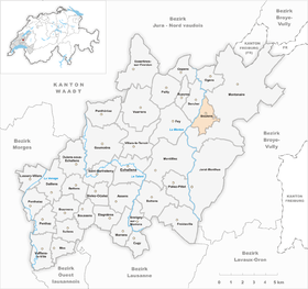
| Location of the municipality | |
  |
|
Boulens is a municipality in the Gros-de-Vaud district in the canton of Vaud in Switzerland .
geography
Boulens is 718 m above sea level. M. , 19 km north of the canton capital Lausanne (linear distance). The clustered village extends on a plateau east of the valley section of the Mentue , in the Molasse hill country of the northern Vaudois Central Plateau .
The area of the 3.5 km² municipal area covers a section of the hill country between the Orbe plain and the central Broyetal . The main part of the area is taken up by the gently undulating high plateau north of the Jorat . The plateau drops steeply to the west of the village. The western border runs along the Mentue, which has carved a valley more than 100 m deep into the molasse layers . The northern and eastern borders are formed by the erosion valley of the Oulaire stream , which is also cut deeply into the plateau. On the western slope of the height Les Bourlayes is 765 m above sea level. M. reached the highest point of Boulens. In 1997, 4% of the municipal area was accounted for by settlements, 34% by forests and woodlands and 62% by agriculture.
A few individual farms belong to Boulens. The neighboring communities of Boulens are in the northeast, east and south Montanaire , in the southwest Fey and in the west and northwest Bercher .
population
With 384 inhabitants (as of December 31, 2018), Boulens is one of the small communities in the canton of Vaud. 90.1% of the residents are French-speaking, 6.2% German-speaking and 1.9% Portuguese-speaking (as of 2000). The population of Boulens was 247 in 1850 and 218 in 1900. After that, due to strong emigration, a decrease to 134 inhabitants was recorded by 1970; since then the population has increased significantly again.
economy
Until the second half of the 20th century, Boulens was a predominantly agricultural village. Even today, arable farming , fruit growing and cattle breeding play an important role in the income structure of the population. Further jobs are available in local small businesses and in the service sector. A mill used to be operated on the Oulaire. In the last few decades the village has also developed into a residential community. Some workers are commuters who work in the surrounding larger towns.
traffic
The community is located off the main thoroughfares, around 1 km from the main road from Lausanne to Thierrens . Boulens is connected to the public transport network through a post bus course that runs from Echallens to Thierrens.
history
The place was first mentioned in a document in 1142 under the name of Bollens . The names Boslens (1166), Boslans (1218), Bolens (1453) appeared later , and the current name has been passed down since the 15th century. The place name goes back to the Burgundian personal name Bollo and means for the people of Bollo .
Since the Middle Ages, Boulens has been under the Cistercian monastery of Montheron . The Counts of Geneva also owned rich estates in the area. After the Reformation , the village came under the rule of Lausanne. With the conquest of Vaud by Bern in 1536, Boulens came under the administration of the Moudon Bailiwick . After the collapse of the Ancien Régime , the village belonged to the canton of Léman from 1798 to 1803 during the Helvetic Republic , which then became part of the canton of Vaud when the mediation constitution came into force . In 1798 it was assigned to the Moudon district.
Attractions
Boulens owned a chapel as early as the 12th century. The current church was rebuilt in 1744. Some characteristic farmhouses from the 18th and 19th centuries have been preserved in the village.
Web links
- Official website of the Municipality of Boulens (French)
- Marianne Stubenvoll: Boulens. In: Historical Lexicon of Switzerland .
- Aerial views of the village
Individual evidence
- ↑ Permanent and non-permanent resident population by year, canton, district, municipality, population type and gender (permanent resident population). In: bfs. admin.ch . Federal Statistical Office (FSO), August 31, 2019, accessed on December 22, 2019 .
Assens | Bercher | Bettens | Bioley-Orjulaz | Bottens | Boulens | Bournens | Boussens | Bretigny-sur-Morrens | Cugy | Daillens | Echallens | Essertines-sur-Yverdon | Etagnières | Fey | Froideville | Goumoëns | Jorat-Menthue | Lussery-Villars | Mex | Montanaire | Morrens | Montilliez | Ogens | Oppens | Oulens-sous-Echallens | Pailly | Penthalaz | Penthaz | Penthéréaz | Poliez-Pittet | Rueyres | Saint Barthélemy | Sullens | Villars-le-Terroir | Vuarrens | Vufflens-la-Ville
Former municipalities: Chapelle-sur-Moudon | Correvon | Denezy | Dommartin | Eclagnens | Goumoens-la-Ville | Goumoens-le-Jux | Lussery | Malapalud | Martherenges | Montaubion Chardonney | Naz | Neyruz-sur-Moudon | Peney-le-Jorat | Peyres-Possens | Poliez-le-Grand | Saint-Cierges | Sottens | Sugnens | Thierrens | Villars-Lussery | Villars-Mendraz | Villars-Tiercelin
Canton of Vaud | Districts of the canton of Vaud | Municipalities of the canton of Vaud