
Hermenches
| Hermenches | |
|---|---|
 |
|
| State : |
|
| Canton : |
|
| District : | Broye-Vully |
| BFS no. : | 5673 |
| Postal code : | 1513 |
| Coordinates : | 547 998 / 165737 |
| Height : | 679 m above sea level M. |
| Height range : | 564–834 m above sea level M. |
| Area : | 4.77 km² |
| Residents: | 364 (December 31, 2018) |
| Population density : | 76 inhabitants per km² |
| Website: | www.hermenches.ch |
 Hermenches |
|
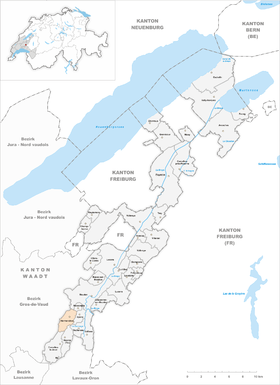
| Location of the municipality | |
  |
|
Hermenches is a municipality in the Broye-Vully district in the canton of Vaud in Switzerland .
geography
Hermenches is 679 m above sea level. M. , 24 km southwest of the district capital Payerne (linear distance). The farming village extends on a ridge east of the Valley of Bressonne , on the Nordostabdachung the high plateau of the Jorat , in the Vaud Plateau .
The area of the 4.8 km² municipal area comprises a section in the northeastern part of the Jorat plateau. The central part of the area is occupied by the height of Hermenches, which is bordered to the west by the valley of the Mérine and to the east by that of the Bressonne. These two valleys are cut deeply into the molasse layers . In the north-east, the communal soil extends to the Le Mont hill ( 728 m above sea level ). The southern part of the municipality is also divided by the valley of the Ruisseau de Corcelles , a left tributary of the Bressonne, and its side streams, including the Ruisseau de Cuchepan . The highest point of Hermenches is 834 m above sea level. M. in the forest area Bois de Ban in the southwest of the village on the ascent to the Jorat plateau. In 1997, 6% of the municipal area was accounted for by settlements, 29% for forests and woodlands and 65% for agriculture.
Hermenches include the farm settlements Moille-Robert ( 660 m above sea level ) and Moille-Cugy ( 741 m above sea level ) on the ridge of Hermenches, Méleries ( 740 m above sea level ) above the valley of the Ruisseau de Corcelles as well as several individual farms. Hermenches' neighboring communities are Moudon , Rossenges , Syens , Vucherens , Ropraz , Corcelles-le-Jorat , Jorat-Menthue .
population
With 364 inhabitants (as of December 31, 2018), Hermenches is one of the small communities in the canton of Vaud. 95.4% of the residents are French-speaking, 2.1% German-speaking and 0.7% Italian-speaking (as of 2000). The population of Hermenches was 317 in 1900. After that, a decrease to 194 inhabitants was recorded by 1970 due to strong emigration; since then, however, the population has increased significantly again.
economy
Hermenches was a predominantly agricultural village until the second half of the 20th century . Even today, arable farming , fruit growing and cattle breeding play an important role in the income structure of the population. Further jobs are available in local small businesses and in the service sector. With the construction of a few single-family houses in the last few decades, the village has also developed into a residential community. Some workers are therefore commuters who work mainly in Moudon and Lausanne .
traffic
The community is located off the main thoroughfares, but can be easily reached from Moudon . Hermenches is connected to the public transport network through a post bus course that runs from Moudon vie Villars-Mendraz to Thierrens .
history
The place was first mentioned in a document in 1254 under the name Ermeiges . Later the names villa de Ermenges (1340), Hermainge (1453) and Hermenges appeared in the 17th century. The place name goes back to the Burgundian personal name Harimôd and means for the people of Harimôd .
Hermenches was probably founded in the 13th century by monks from the Cistercian monastery of Haut-Crêt , who made the area on the eastern slope of the Jorat arable. With the conquest of Vaud by Bern in 1536, Hermenches came under the administration of the Moudon Bailiwick . From the 16th to the 18th century, the village formed its own small lordship. After the collapse of the Ancien Régime , Hermenches belonged to the canton of Léman from 1798 to 1803 during the Helvetic Republic , which then became part of the canton of Vaud when the mediation constitution came into force . In 1798 it was assigned to the Moudon district.
Attractions
The village school house with bell tower and integrated chapel was built in 1761. The origins of the castle go back to 1648; later the building was rebuilt several times and now serves as a retirement and nursing home. Some characteristic farmhouses from the 18th and 19th centuries have been preserved in the town center.
literature
- Monique Fontannaz, Brigitte Pradervand: Le district de la Broye-Vully 1. (= The art monuments of Switzerland. Volume 128). Ed. Society for Swiss Art History SKG. Bern 2015, pp. 71–78, ISBN 978-3-03797-180-2 .
Web links
- Official website of the municipality of Hermenches (French)
- Valérie Favez: Hermenches. In: Historical Lexicon of Switzerland .
- Aerial views of the village
Individual evidence
- ↑ Permanent and non-permanent resident population by year, canton, district, municipality, population type and gender (permanent resident population). In: bfs. admin.ch . Federal Statistical Office (FSO), August 31, 2019, accessed on December 22, 2019 .
Avenches | Bussy-sur-Moudon | Champtauroz | Chavannes-sur-Moudon | Chevroux | Corcelles-le-Jorat | Corcelles-près-Payerne | Cudrefin | Curtilles | Dompierre | Faoug | Grandcour | Henniez | Hermenches | Lovatens | Lucens | Missy | Moudon | Payerne | Prévonloup | Ropraz | Rossenges | Syens | Trey | Treytorrens (Payerne) | Valbroye | Villars-le-Comte | Villarzel | Vucherens | Vulliens | Vully-les-Lacs
Former parishes: Bellerive | Brenles | Carrouge | Cerniaz | Chabrey | Champmartin | Chesalles-sur-Moudon | Combremont-le-Grand | Combremont-le-Petit | Constantine | Cremin | Forel-sur-Lucens | Donatyre | Granges-près-Marnand | Marnand | Montmagny | Mur | Oleyres | Oulens-sur-Lucens | Rossens | Sarzens | Sassel | Sédeilles | Seigneux | Vallamand | Villars-Bramard | Villars-le-Grand
Canton of Vaud | Districts of the canton of Vaud | Municipalities of the canton of Vaud