Corcelles-près-Payerne
| Corcelles-près-Payerne | |
|---|---|
| State : |
|
| Canton : |
|
| District : | Broye-Vully |
| BFS no. : | 5816 |
| Postal code : | 1562 |
| UN / LOCODE : | CH COR |
| Coordinates : | 563 651 / 186712 |
| Height : | 454 m above sea level M. |
| Height range : | 432-529 m above sea level M. |
| Area : | 12.11 km² |
| Residents: | 2480 (December 31, 2018) |
| Population density : | 205 inhabitants per km² |
| Website: | www.corcelles.ch |
|
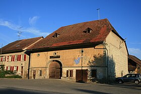
Farmhouse in Corcelles-près-Payerne |
|
| Location of the municipality | |
Corcelles-près-Payerne is a municipality in the Broye-Vully district in the canton of Vaud in Switzerland .
geography
Corcelles-près-Payerne is 454 m above sea level. M. , 2 km northeast of the district capital Payerne (air line). The village extends on the southern edge of the Broye plain, on both sides of the Arbogne river , where it emerges from the Friborg Molasse hill country, in the north-eastern Vaud Central Plateau .
The area of the 12.2 km² municipal area includes a section of the Broye plain. The northern border of Corcelles-près-Payerne runs partly along the A1 motorway . From here the communal soil extends southward over the canalized Broye and the intensely agricultural plain, in which the former broye river bed is marked by a row of trees, to the Arbogne. The southern part of the municipality extends into the slightly elevated areas of the Molasse hill country on both sides of the Arbogne. At the height of Boulex at the west foot of the Petit Belmont is at 526 m above sea level. M. the highest point of Corcelles-près-Payerne reached. East of the Arbogne is the small enclave Tours, which belongs to the municipality of Montagny in the canton of Friborg . The southern border is formed in parts by the Arbogne and its right side stream Ruisseau du Creux and its left tributary Motélon . In 1997, 10% of the municipal area was in settlements, 4% in forests and woodland, 84% in agriculture and a little over 2% was unproductive land.
Corcelles-près-Payerne includes the hamlet of Pont Neuf ( 444 m above sea level ) on the Broye and several individual farms. Corcelles-près-Payerne's neighboring municipalities are Payerne , Grandcour and Missy in the canton of Vaud and Vallon , Belmont-Broye and Montagny in the canton of Friborg.
population
With 2,480 inhabitants (as of December 31, 2018) Corcelles-près-Payerne is one of the medium-sized municipalities in the canton of Vaud and is also the second largest town in the Payerne district. 89.1% of the residents are French-speaking, 5.5% German-speaking and 1.5% Portuguese-speaking (as of 2000). The population of Corcelles-près-Payerne was 880 in 1850 and 1189 in 1900. After the population had increased only slightly until 1980 (1308 inhabitants), a significantly increased population increase has been registered since then. The settlement area of Corcelles-près-Payerne has now seamlessly merged with that of Payerne.
economy
The agriculture always had an important place in Corcelles-près-Payerne, was harnessed especially since the construction of the Broye Canal (1906) as the fertile alluvial plain of Broye for intensive agriculture. Horse breeding played a major role in the 18th century . Even today, arable farming , fruit growing and cattle breeding play an important role in the income structure of the population.
An important employer in the secondary sector is the Morandi brickworks, which has been mechanized since 1896 and owned the largest kiln in Switzerland around 1930. There are numerous other jobs in small and medium-sized companies, including in a factory for watch cases, in the construction industry, in wood processing and in precision engineering. In the last few decades the village has also developed into a residential community. Many workers are commuters who work mainly in Payerne.
traffic
The community has good transport connections. It is located on main road 1 from Bern via Payerne to Lausanne . Transit traffic is routed around Corcelles-près-Payerne on a bypass. The closest motorway connections to the A1 (Lausanne-Bern) are Payerne (to the west) and Avenches (to the east).
The village has two railway stations: on August 25, 1876, the Murten -Payerne railway line with the Corcelles-Nord station was opened, and the Payerne-Freiburg line with the Corcelles-Sud station was opened on the same day.
history

In Roman times , the road from Avenches to Payerne crossed the municipality of Corcelles-près-Payerne. There are individual remains of an aqueduct that was used to convey water from Lac de Seedorf to Aventicum. The first written mention of the place was in 1228 under the name Corzales , in 1235 the spelling Corsales appeared . The place name is derived from the Latin word corticella (small courtyard).
Corcelles-près-Payerne has belonged to the Payerne monastery since the Middle Ages . With the conquest of Vaud by Bern in 1536, the village came under the administration of the Payerne governorate . After the collapse of the Ancien Régime , Corcelles-près-Payerne belonged to the canton of Léman from 1798 to 1803 during the Helvetic Republic, which then became part of the canton of Vaud when the mediation constitution came into force . In 1798 it was assigned to the Payerne district. However, the place only became an independent municipality in 1806 after it was separated from Payerne.
Attractions
The core of the Reformed Church of Saint-Nicolas dates back to the 11th century. Originally Romanesque , the church has been redesigned and restored several times. The single-nave building has a round apse; the bell tower, which is also Romanesque, was not built until the beginning of the 17th century. The rectory in the Neuchâtel style dates from 1744. In the old town center, some characteristic farmhouses from the 17th to 19th centuries have been preserved. The numerous granaries made of wood and stone are a special feature.
Web links
- Official website of the municipality of Corcelles-près-Payerne (French)
- Gilbert Marion: Corcelles-près-Payerne. In: Historical Lexicon of Switzerland .
- Aerial views of the village
Individual evidence
- ↑ Permanent and non-permanent resident population by year, canton, district, municipality, population type and gender (permanent resident population). In: bfs. admin.ch . Federal Statistical Office (FSO), August 31, 2019, accessed on December 22, 2019 .


