
Constantine VD
| VD is the abbreviation for the canton of Vaud in Switzerland and is used to avoid confusion with other entries of the name Constantine . |
| Constantine | ||
|---|---|---|
 |
||
| State : |
|
|
| Canton : |
|
|
| District : | Broye-Vully | |
| Municipality : | Vully-les-Lacs | |
| Postal code : | 1587 | |
| former BFS no. : | 5455 | |
| Coordinates : | 567 499 / 196 510 | |
| Height : | 510 m above sea level M. | |
| Area : | 2.83 km² | |
| Residents: | 327 (December 31, 2010) | |
| Population density : | 116 inhabitants per km² | |
| Website: | www.vully-les-lacs.ch | |
| map | ||
|
||


Constantine was a municipality in the Broye-Vully district in the canton of Vaud in Switzerland .
The merger of Constantine with the municipalities of Bellerive (VD) , Chabrey , Montmagny , Mur (VD) , Vallamand and Villars-le-Grand to form the municipality of Vully-les-Lacs was completed on July 1, 2011.
geography
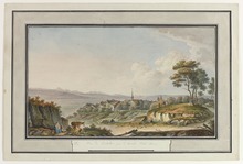
Constantine is at 510 m above sea level. M. , 12 kilometers northeast of the district capital Payerne (linear distance ). The clustered village extends over a promontory on the southern slope of the ridge between Lake Neuchâtel and Lake Murten , in a panoramic position around 80 m above the Broye plain , in the Swiss plateau .
The area of the 2.8 km² municipal area includes a section of the Broye plain and the adjacent ridge. The western part of the municipality is occupied by the Champs Goliard protrusion on the southern slope of the foothills of Mont Vully . To the east of the village of Constantine, the slope is interrupted by a deep erosion valley that forms the border against Bellerive. The highest point in the community is 522 m above sea level. M. below Montmagny. To the southeast, the municipality extends into the agriculturally intensively used area of the Broye plain and over the River Broye to the west bank of Lake Murten. In 1997, 13% of the municipal area was accounted for by settlements, 15% by forests and woodlands, 71% by agriculture and a little more than 1% was unproductive land.
The southern part of the village Salavaux ( 436 m above sea level ) in the Broye plain at the confluence of the Petite Glâne in the Broye and some individual farms belong to Constantine . Neighboring parishes of Constantine were Avenches , Montmagny and Bellerive .
population
With 327 inhabitants (as of December 31, 2010) Constantine was one of the small communities in the canton of Vaud. 82.9% of the residents are French-speaking, 10.7% German-speaking and 3.6% Portuguese-speaking (as of 2000). The population of Constantine was 193 in 1850 and 189 in 1900. The population remained stable until 1970, since then a significant increase in population has been registered.
economy
Until the second half of the 20th century, Constantine was predominantly an agricultural village. Even today, the have farming , the fruit growing and viticulture (on the southern slope below the village) play an important role in the employment structure of the population. There is a flour mill in Salavaux. Further jobs are available in local small businesses and especially in the service sector. In the last few decades the village has also developed into a residential community. Some workers are commuters who work in the surrounding larger towns.
traffic
The community is very well developed in terms of traffic, although it is located away from the major thoroughfares. The Avenches motorway junction on the A1 (Lausanne-Bern) is around 6 km from the town center. Constantine is connected to the public transport network via the Postbus course, which runs from Avenches to Cudrefin .
history
The place was first mentioned in a document in 1228 under the name Costantina . The place name goes back to the Latin personal name Constantius . In the Middle Ages Constantine was owned by the Bishop of Sion, who sold his property on Mont Vully to Peter of Savoy around 1250 . Since then the village belongs to the Kastlanei Cudrefin.
With the conquest of Vaud by Bern in 1536, the village came under the administration of the Bailiwick of Avenches . After the collapse of the Ancien Régime , Constantine was annexed to the canton of Friborg during the Helvetic Republic in 1798 . When the Mediation Constitution came into force in 1803, the village, together with what is now the Avenches district, was reassigned to the Canton of Vaud as an exclave. Until 1811 Constantine formed a large community with the neighboring villages of Bellerive and Montmagny.
Attractions
The Romanesque building of the parish church of Saint-Martin was redesigned in 1675; the rectory received its present form in 1671. The manor house, built in 1677, has housed a holiday and rest home since 1919. In the old town center of Constantine some stately farmhouses from the 17th to 19th centuries have been preserved. Salavaux Castle, originally built in the 13th century, is located on the municipal boundary of Bellerive, on the western outskirts of Salavaux. It still has a round tower from the time it was founded; most of the residential buildings, however, date from the 19th century.
Web links
- Community information
- Gilbert Marion: Constantine. In: Historical Lexicon of Switzerland .
- Aerial views of the village
Avenches | Bussy-sur-Moudon | Champtauroz | Chavannes-sur-Moudon | Chevroux | Corcelles-le-Jorat | Corcelles-près-Payerne | Cudrefin | Curtilles | Dompierre | Faoug | Grandcour | Henniez | Hermenches | Lovatens | Lucens | Missy | Moudon | Payerne | Prévonloup | Ropraz | Rossenges | Syens | Trey | Treytorrens (Payerne) | Valbroye | Villars-le-Comte | Villarzel | Vucherens | Vulliens | Vully-les-Lacs
Former parishes: Bellerive | Brenles | Carrouge | Cerniaz | Chabrey | Champmartin | Chesalles-sur-Moudon | Combremont-le-Grand | Combremont-le-Petit | Constantine | Cremin | Forel-sur-Lucens | Donatyre | Granges-près-Marnand | Marnand | Montmagny | Mur | Oleyres | Oulens-sur-Lucens | Rossens | Sarzens | Sassel | Sédeilles | Seigneux | Vallamand | Villars-Bramard | Villars-le-Grand
Canton of Vaud | Districts of the canton of Vaud | Municipalities of the canton of Vaud