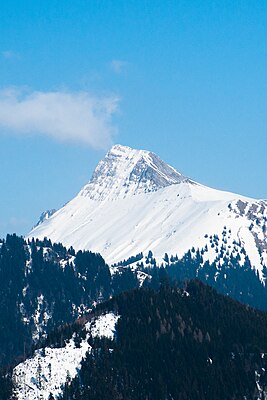
Dent de Lys
| Dent de Lys | ||
|---|---|---|
|
View of Les Pléiades (west side) |
||
| height | 2014.1 m above sea level M. | |
| location | Canton of Friborg , Switzerland | |
| Mountains | Freiburg Pre-Alps | |
| Dominance | 7.6 km → at Pointe de Cray | |
| Notch height | 502 m ↓ Col de Jaman | |
| Coordinates | 566 565 / 150 804 | |
|
|
||
| particularities | highest point in Châtel-Saint-Denis | |
The Dent de Lys is a 2014.1 m above sea level. M. high mountain peak in the Friborg Prealps in the Swiss canton of Friborg . It is usually climbed from the Col de Lys pass ( 1783 m above sea level ), via which the summit can be reached via a ridge.
geography
The mountain top forms the natural border between the communes of Châtel-Saint-Denis on the west and Haut-Intyamon in the valley of the Hongrin on the east. Folliu Borna ( 1849 m above sea level ), Vanil des Artses ( 1991 m above sea level ), Cape au Moine ( 1941 m above sea level ), Dent de Jaman ( 1875 m above sea level ) are located to the south of the mountain range . ) and the Rochers de Naye ( 2042 m above sea level ), to the north rises the Vanil Blanc ( 1828 m above sea level ) and the Vanil de l'Arche ( 1581 m above sea level ). The Veveyse and the Marive have their source at Dent de Lys .


