Col de Lys
| Col de Lys | |||
|---|---|---|---|
|
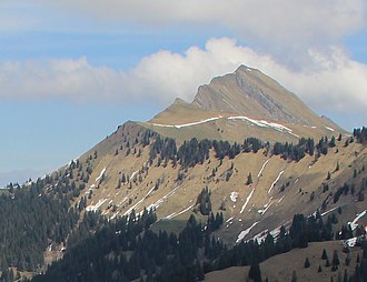
View from the Col de Soladier to the Dent de Lys , to the left of which the pre-summit Lys Derrey and the Col de Lys at the left end of the snow band to the left of the center of the picture |
|||
| Compass direction | west | east | |
| Pass height | 1779 m above sea level M. | ||
| Canton | Freiburg | ||
| Watershed | Veveyse | Hongrin | |
| Valley locations | Les Paccots , Châtel-Saint-Denis | Les Sciernes d'Albeuve , Montbovon | |
| expansion | Mountain hiking trail | ||
| map | |||
|
|
|||
| Coordinates | 565 703 / 150176 | ||
The Col de Lys ( 1779 m ) is a pass in the Friborg Prealps in the Swiss canton of Friborg .
It is to be distinguished from the 4151 m high Lysjoch or Lisjoch ( French Col du Lys ) between the Mattertal in the canton of Valais and the Italian Lystal .
location
The pass crosses the steep ridge between Dent de Lys ( 2013 m ) and Folliu Borna ( 1848 m ). It lies between the valleys of the Veveyse , which flows into Lake Geneva , and the valley of the Hongrin , a tributary of the Saane . The leading over the pass mule track connects the to Châtel-Saint-Denis part of Les Paccots in the West with about Montbovon belonging settlement Les Sciernes d'Albeuve .
From the pass to the northeast, a ridge stretches across the secondary summit Lys Derrey ( 1863 m , also Mys Derrey) to Dent de Lys, on which the normal route to this summit runs. The ridge climbs a few meters to the south and then drops to a good 1700 m . This is followed by the mountains Folliu Borna ( 1848 m ) and Vanil des Artses ( 1991 m ).
To the west leads a ridge on which the mountain trail from Les Paccots runs. To the north of this ridge, the Veveyse de Châtel rises just below the pass , and to the south of the ridge is a torrent that flows into the Veveyse de Fégire . Both later together form the Veveyse. A mountain hiking trail leads south-east into the Flon valley , which flows into the Hongrin at Montbovon . This means that the pass lies on the European watershed between the catchment areas of the Rhine (on the Saane) and the Rhone .
In the area of the pass, the ridge forms the western border of the Parc naturel régional Gruyère Pays-d'Enhaut , a park of national importance .
Surname
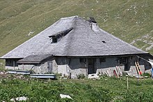
The name Lys comes from a small lake east of the pass (dialect li = lake). This underground lake is fed by a spring, the water flow of which fluctuates strongly, so that it is often almost dry in summer. There you will find the En Lys alpine hut listed in the list of cultural assets of national importance in the canton of Friborg .
Web links
- Col de Lys on hikr.org
Individual evidence
- ↑ a b c Col de Lys on the national map of Switzerland .
- ↑ Lys Derrey in the tour portal of the Swiss Alpine Club and on hikr.org , accessed on March 8, 2020. In the digital version of the national map of Switzerland as Lys Derrey at 1863 m , in the 2018 map as Mys Derrey at 1864 m .
- ^ A b Charles Knapp, Maurice Borel, Victor Attinger, Heinrich Brunner, Société neuchâteloise de geographie (editor): Geographical Lexicon of Switzerland . Volume 3: Krailigen - Plentsch . Verlag Gebrüder Attinger, Neuenburg 1905, p. 251, keyword Lys (Col de) ( scan of the lexicon page ).


