Foopass
| Foopass | |||
|---|---|---|---|
|
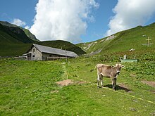
View from the pass to the canton of Glarus (to the west) |
|||
| Compass direction | west | east | |
| Pass height | 2223 m above sea level M. | ||
| region | Glarus , Switzerland | Canton of St. Gallen , Switzerland | |
| Valley locations | Elm | Silver firs | |
| expansion | Mountain path | ||
| Mountains | Glarus Alps | ||
| Map (Glarus) | |||
|
|
|||
| Coordinates | 737 003 / 200650 | ||
The Foopass at 2223 m above sea level. M. is a high mountain pass in the Glarus Alps . It lies on the border between the Swiss cantons of Glarus and St. Gallen and connects Elm (Glarus) and Weisstannen (St. Gallen). The Foopass is the southernmost pass between the two cantons, over which a path leads. This is the Via Alpina Green Path .
The pass is dominated by the Foostock and the Piz Sardona .
About 2 km east of the Foopass is the Alp Foo (overnight accommodation for mountain hikers).


